
Därligen facts for kids
Quick facts for kids
Därligen
|
||
|---|---|---|
_060.JPG)
Därligen village on the shores of Lake Thun
|
||
|
||

Därligen
Location in Switzerland

Därligen
Location in Canton of Bern
|
||
| Country | Switzerland | |
| Canton | Bern | |
| District | Interlaken-Oberhasli | |
| Area | ||
| • Total | 6.93 km2 (2.68 sq mi) | |
| Elevation | 567 m (1,860 ft) | |
| Population
(Dec 2020 )
|
||
| • Total | 415 | |
| • Density | 59.88/km2 (155.10/sq mi) | |
| Postal code |
3707
|
|
| Surrounded by | Interlaken, Matten bei Interlaken, Wilderswil, Saxeten and Leissigen | |

Därligen is a small town, also called a municipality, in Switzerland. It is located in the Interlaken-Oberhasli area within the canton of Bern. Därligen is known for its beautiful location on the shores of Lake Thun.
Contents
History of Därligen
Därligen was first mentioned in official records in the year 1244. Back then, its name was written as Tedningen.
Early Settlements and Rule
The very first signs of people living in this area come from the Bronze Age. Old tools and items from that time have been found near the lake. During the Middle Ages, Därligen was part of a local lordship called Herrschaft of Unspunnen. This meant it was ruled by a local noble family. In 1515, the larger city of Bern took control of Därligen.
The Important Railway Line
A special railway line called the Bödelibahn opened in 1872. It connected Därligen to Interlaken. Later, in 1874, it was extended to Bönigen. At first, this railway was not connected to the main Swiss train system. It was used to move people and goods between steamships on two different lakes. Everything had to be transferred from boats to trains at Därligen.
However, in 1893, the railway line was extended further west to Thun. From Thun, people could travel to Bern and other places. This meant that transfers at Därligen were no longer needed. This railway line eventually became part of the important Bern–Lötschberg–Simplon railway network.
Geography of Därligen
_133.JPG)
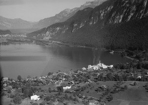
Därligen is located in the Bernese Oberland region of Switzerland. It sits on the southern shore of Lake Thun. The town itself is right by the lake, where the Aare River canal flows out. The municipality's land stretches up to the Därliggrat ridge. The town also has its own railway station.
Land Use in Därligen
Därligen covers an area of about 6.9 square kilometers (2.7 square miles). A good portion of this land is used for different purposes:
- About 19.5% of the land is used for farming.
- A large part, about 65.4%, is covered by forests.
- Around 5.8% of the land has buildings or roads.
- A small amount, 0.4%, is rivers or lakes.
- About 8.0% is unproductive land, meaning it cannot be used for farming or building.
Most of the forested land is dense forest, and some areas have small groups of trees or orchards. The farming land includes pastures for animals. All the water in Därligen is flowing water, like rivers. Some unproductive areas have plants that don't grow well, or they are too rocky.
In 2010, Därligen became part of a new administrative area called Verwaltungskreis Interlaken-Oberhasli.
Därligen's Coat of Arms
The blazon (official description) of Därligen's municipal coat of arms is quite interesting. It shows a golden sailboat with a silver sail on a blue background. The bottom of the shield has wavy silver and black lines, representing water.
Population and People
Därligen has a population of about 413 people (as of December 2010). Over the past ten years (2000-2010), the population has grown by about 13.3%. This growth was mostly due to people moving into the town.
Languages Spoken
Most people in Därligen speak German as their main language. In 2000, about 94.2% of the population spoke German. Other languages spoken include Albanian (1.9%) and French (1.7%). A few people also speak Italian or Romansh.
Age Groups and Origin
In 2010, the population of Därligen was made up of:
- Children and teenagers (0–19 years old): 20.6%
- Adults (20–64 years old): 62.7%
- Seniors (over 64 years old): 16.7%
Many people living in Därligen were born there or in the same canton (Bern). About 7% of the population was born outside of Switzerland.
Population Changes Over Time
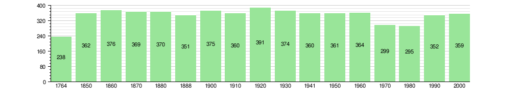
The chart below shows how Därligen's population has changed over many years:
Economy of Därligen
In 2011, Därligen had a low unemployment rate of 2.99%. This means most people who wanted to work had jobs.
Types of Jobs
In 2008, there were 61 people working in Därligen. Jobs are often grouped into three main types:
- Primary sector: This includes jobs that get raw materials from nature. In Därligen, 18 people worked in this sector, mostly in farming.
- Secondary sector: This involves making things. Six people worked in this sector, in areas like manufacturing and construction.
- Tertiary sector: This includes jobs that provide services. The largest group, 37 people, worked in this sector. These jobs included working in hotels or restaurants, being technical experts, or working in education.
Many people who live in Därligen travel to other towns for work. In 2000, about 159 people commuted out of Därligen for their jobs, while 37 people came into Därligen to work. Most people used a private car to get to work, while some used public transportation.
Religion in Därligen
Based on a 2000 survey, most people in Därligen belong to the Swiss Reformed Church, which is a Protestant church. About 77.4% of the population identified with this church. Around 10.6% were Roman Catholic. There were also people who belonged to other Christian churches or were Islamic. A small number of people did not belong to any church.
Transport in Därligen
Därligen has regular bus services that connect it to nearby towns like Spiez and Interlaken. In the past, Därligen also had its own railway station on the Lake Thun line.
See also
 In Spanish: Därligen para niños
