
Bönigen facts for kids
Quick facts for kids
Bönigen
|
||
|---|---|---|

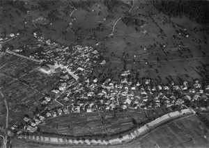
Bönigen from Lake Brienz
|
||
|
||

Bönigen
Location in Switzerland

Bönigen
Location in Canton of Bern
|
||
| Country | Switzerland | |
| Canton | Bern | |
| District | Interlaken-Oberhasli | |
| Area | ||
| • Total | 15.1 km2 (5.8 sq mi) | |
| Elevation | 568 m (1,864 ft) | |
| Population
(Dec 2020 )
|
||
| • Total | 2,569 | |
| • Density | 170.1/km2 (440.6/sq mi) | |
| Postal code |
3806
|
|
| Surrounded by | Iseltwald, Gündlischwand, Gsteigwiler, Matten bei Interlaken, Wilderswil, Interlaken | |

Bönigen is a lovely village and municipality in Switzerland. It's located in the canton of Bern, specifically in the Interlaken-Oberhasli area. Bönigen sits right on the edge of Lake Brienz, close to where the Lütschine river flows into the lake. It's also very near the popular tourist town of Interlaken.
Bönigen is part of a larger group of towns called the Interlaken Agglomeration, which had about 23,300 people in 2014. The village also belongs to the church parish of Gsteig bei Interlaken, which includes eight other nearby communities.
Contents
History of Bönigen
Bönigen was first written about in the year 1261. Back then, it was called villa Boningen. Its name means "of the people of the Bono clan," which comes from an old German personal name.
In 1261, a nobleman called the Freiherr of Eschenbach gave some land in Bönigen to the Interlaken Monastery (a religious community). He gave even more land in 1275. For a long time, Bönigen was involved in many disagreements in the Bernese Oberland region.
For example, in 1330, the people of the Oberhasli valley fought against their ruler in a conflict known as the Weissenburger War. The Oberhasli army was defeated near Bönigen. About 20 years later, in 1349, Bönigen joined another fight against the growing power of Interlaken Monastery, but this rebellion also failed.
In 1528, the city of Bern decided to change its religion to Protestantism. They told all the nearby areas to do the same. Bönigen was part of the group that resisted this change, but they were not successful. After Bern took control, they closed Interlaken Monastery and took all its land. Bönigen then became part of Bern's bailiwick (an area governed by a special officer) called Interlaken.
Later, in 1798, France invaded Switzerland. Bönigen became part of a new area called the Helvetic Republic Canton of Oberland. This new canton only lasted a few years. In 1803, with the Act of Mediation, it became part of the Canton of Bern again. Even after this, Bönigen tried twice, in 1814 and 1836, to bring back the Canton of Oberland.
Originally, the village was built on a hill to avoid floods from the lake and streams. But in the 1800s, people started projects to control the river and prevent floods. Around 1860, these projects made the lake shore stable and lowered the water level. This allowed the village to grow closer to the streams and the lake.
In 1874, a railway line called the Bödelibahn reached Bönigen. This line connected Bönigen to Därligen on Lake Thun, passing through Interlaken. For many years, this railway was separate from the main Swiss railway system. It helped people travel between the steamships on Lake Thun and Lake Brienz. Bönigen was the end of this line until 1969, when passenger trains stopped going there. However, the railway company, Bern–Lötschberg–Simplon railway (BLS), built its main workshops in Bönigen, and these are still open today.
Geography of Bönigen

Bönigen is located in the beautiful Bernese Oberland region. It's on the southwest side of Lake Brienz, right where the Lütschine river flows into the lake. The main part of the village is in the northwest, along the river and by the lake. Bönigen has grown so much that it almost connects with the nearby town of Interlaken.
Most of the municipality's land is made up of steep mountains. Some of the peaks you can find here include the Loucherhorn (about 2,230 meters or 7,316 feet tall) and the Roteflue (about 2,296 meters or 7,533 feet tall). The famous Schynige Platte is also in this area.
Bönigen covers an area of about 15.1 square kilometers (5.8 square miles). A large part of this land, about 57%, is covered by forests. About 16% is used for farming, and a smaller part, about 6%, has buildings and roads.
In 2010, the old district of Interlaken was closed. Bönigen then became part of the new Interlaken-Oberhasli administrative district.
Coat of Arms
The coat of arms for Bönigen shows a black eagle with a gold crown on a gold background at the top. Below that, it has a black ibex (a type of wild goat) standing on its hind legs, with a red tongue, on a silver background.
People of Bönigen (Demographics)
As of 2010, Bönigen had a population of 2,444 people. About 6.2% of these people were from other countries. Over the ten years from 2000 to 2010, the population grew by about 10%.
Most people in Bönigen (about 95%) speak German as their main language. A smaller number of people speak English or Italian.
In 2008, about 49% of the population was male and 51% was female. Many people who live in Bönigen were also born there or in the same canton (region).
In 2010, children and teenagers (up to 19 years old) made up about 21% of the population. Adults (20-64 years old) made up about 61%, and seniors (over 64 years old) made up about 17.5%.
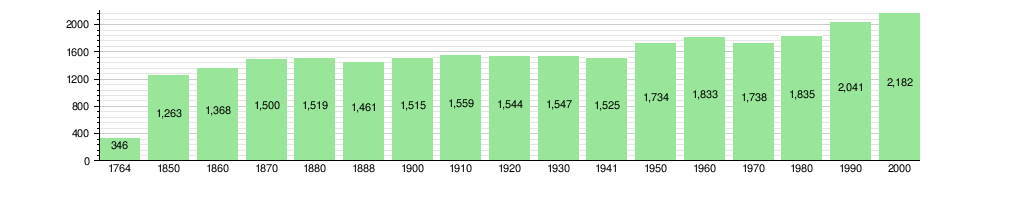
The chart below shows how the population of Bönigen has changed over many years:
Special Places in Bönigen
The entire village of Bönigen is considered a special place as part of the Inventory of Swiss Heritage Sites. This means it has important historical and cultural value.
Economy and Jobs
In 2011, the unemployment rate in Bönigen was quite low, at 1.45%. In 2008, there were 682 people working in the municipality.
People in Bönigen work in different areas:
- Primary sector: This includes jobs like farming and forestry.
- Secondary sector: This includes jobs in manufacturing (making things) and construction (building things).
- Tertiary sector: This includes jobs in services, like sales, transportation, hotels, restaurants, and healthcare.
Many people who live in Bönigen also travel to other towns for work. In 2000, about 13.8% of workers used public transportation, and 47.1% used a private car to get to their jobs.
Religion in Bönigen
According to a census in 2000, most people in Bönigen belonged to the Swiss Reformed Church (about 75%). About 11.6% were Roman Catholic. There were also smaller numbers of people who belonged to other Christian churches, or were Muslim, Jewish, Buddhist, or Hindu. Some people did not belong to any church.
Education in Bönigen
In Bönigen, about 46% of the population has finished upper secondary education (like high school). About 8% have gone on to higher education, such as university.
The school system in the Canton of Bern starts with one year of optional Kindergarten. After that, students go to six years of Primary school. Then, they have three years of lower Secondary school, where students are grouped by their abilities. After lower Secondary, students can continue their schooling or start an apprenticeship (learning a trade on the job).
During the 2010-2011 school year, there were 218 students in Bönigen schools. There were 43 students in kindergarten and 145 students in primary school. There were also 30 students in lower secondary classes.
Bönigen has its own municipal library, called the Schul- und Gemeindebibliothek Bönigen. In 2008, the library had almost 6,800 books and other media. It loaned out over 14,500 items that year.
See also
 In Spanish: Bönigen para niños
