Daisy, Georgia facts for kids
Quick facts for kids
Daisy, Georgia
|
|
|---|---|

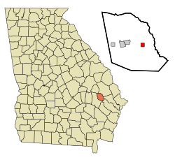
Location in Evans County and the state of Georgia
|
|
| Country | United States |
| State | Georgia |
| County | Evans |
| Area | |
| • Total | 1.02 sq mi (2.64 km2) |
| • Land | 0.96 sq mi (2.49 km2) |
| • Water | 0.06 sq mi (0.14 km2) |
| Elevation | 151 ft (46 m) |
| Population | |
| • Total | 159 |
| • Density | 165.11/sq mi (63.77/km2) |
| Time zone | UTC-5 (Eastern (EST)) |
| • Summer (DST) | UTC-4 (EDT) |
| ZIP code |
30423
|
| Area code(s) | 912 |
| FIPS code | 13-21268 |
| GNIS feature ID | 0355421 |
Daisy is a small city located in Evans County, Georgia, in the United States. In 2020, about 159 people called Daisy home. It's a quiet place with an interesting past, especially linked to railroads!
History of Daisy
The city of Daisy, Georgia, was founded in 1890. This was the same year that the Savannah and Western Railroad built a railroad line right through the area.
The town was first going to be named Conley. This name was chosen to honor Rev. W.F. Conley, a Methodist minister. However, the postal service said no to this name on May 17, 1890. There was already another town called Conley, Georgia, and they didn't want confusion.
So, the people of the community decided on a new name: Daisy. They named their town after Daisy Leola Edwards. She was the daughter of Thomas Jefferson Edwards and the granddaughter of Rev. W.F. Conley. The request for a post office with the name Daisy was sent on July 14, 1890. It was officially approved on August 26, 1890.
Geography of Daisy
Daisy is located at coordinates 32°9′0″N 81°50′9″W / 32.15000°N 81.83583°W. This helps us find it on a map!
According to the United States Census Bureau, the city covers a total area of about 1.0 square mile (2.6 square kilometers). Most of this area is land, about 1.0 square mile (2.5 square kilometers). A small part, about 0.04 square miles (0.1 square kilometers), is water.
Climate in Daisy
Daisy has a humid subtropical climate. This means it has hot and humid summers. In July, the average high temperature is about 94 degrees Fahrenheit (34 degrees Celsius). The average low is around 70 degrees Fahrenheit (21 degrees Celsius).
Winters in Daisy are usually mild. In January, the average high is about 61 degrees Fahrenheit (16 degrees Celsius). The average low is around 36 degrees Fahrenheit (2 degrees Celsius). It doesn't snow very often, but winter storms can happen sometimes.
| Climate data for Daisy | |||||||||||||
|---|---|---|---|---|---|---|---|---|---|---|---|---|---|
| Month | Jan | Feb | Mar | Apr | May | Jun | Jul | Aug | Sep | Oct | Nov | Dec | Year |
| Record high °F (°C) | 81 (27) |
86 (30) |
89 (32) |
96 (36) |
98 (37) |
106 (41) |
107 (42) |
105 (41) |
104 (40) |
96 (36) |
87 (31) |
84 (29) |
107 (42) |
| Mean daily maximum °F (°C) | 61 (16) |
66 (19) |
73 (23) |
78 (26) |
86 (30) |
91 (33) |
94 (34) |
92 (33) |
87 (31) |
80 (27) |
71 (22) |
63 (17) |
79 (26) |
| Mean daily minimum °F (°C) | 36 (2) |
39 (4) |
44 (7) |
50 (10) |
59 (15) |
67 (19) |
71 (22) |
70 (21) |
65 (18) |
54 (12) |
45 (7) |
38 (3) |
53 (12) |
| Record low °F (°C) | −2 (−19) |
13 (−11) |
16 (−9) |
28 (−2) |
41 (5) |
48 (9) |
58 (14) |
56 (13) |
45 (7) |
30 (−1) |
22 (−6) |
13 (−11) |
−2 (−19) |
| Average precipitation inches (mm) | 4.36 (111) |
3.57 (91) |
3.25 (83) |
2.95 (75) |
3.21 (82) |
5.12 (130) |
4.68 (119) |
5.41 (137) |
3.73 (95) |
3.87 (98) |
2.49 (63) |
3.17 (81) |
3.82 (97) |
| Source: The Weather Channel | |||||||||||||
Population of Daisy
| Historical population | |||
|---|---|---|---|
| Census | Pop. | %± | |
| 1930 | 214 | — | |
| 1940 | 294 | 37.4% | |
| 1950 | 195 | −33.7% | |
| 1960 | 229 | 17.4% | |
| 1970 | 150 | −34.5% | |
| 1980 | 174 | 16.0% | |
| 1990 | 138 | −20.7% | |
| 2000 | 126 | −8.7% | |
| 2010 | 129 | 2.4% | |
| 2020 | 159 | 23.3% | |
| U.S. Decennial Census | |||
The population of Daisy changes over time. In the year 2000, there were 126 people living in the city. These people made up 53 households, with 33 of them being families. By the year 2020, the population of Daisy had grown to 159 people.
See also
 In Spanish: Daisy (Georgia) para niños
 | John T. Biggers |
 | Thomas Blackshear |
 | Mark Bradford |
 | Beverly Buchanan |


