
Dalry, Edinburgh facts for kids
Quick facts for kids Dalry |
|
|---|---|
 Dalry Road |
|
| Population | Unknown |
| Council area |
|
| Country | Scotland |
| Sovereign state | United Kingdom |
| Post town | Edinburgh |
| Postcode district | EH11 |
| Ambulance | Scottish |
| EU Parliament | Scotland |
| UK Parliament |
|
| Scottish Parliament |
|
Dalry is a cool area in Edinburgh, the capital city of Scotland. It's super close to the city centre, nestled between Haymarket and Gorgie. Today, Dalry is mostly a place where people live.
The heart of Dalry is Dalry Road. This street is buzzing with shops, restaurants, and small businesses. Long ago, Dalry was farmland outside the old city walls. It was part of a big farm estate called Dalry House, built in 1661. There was also the Dalry Mill, which was Scotland's oldest paper mill, but it's not there anymore.
During the Victorian times, Dalry grew a lot. Factories and railway lines appeared where fields used to be. Many large apartment buildings, called tenements, were also built. Now, most of the old factories are gone. Their sites have been turned into homes.
Contents
What Does Dalry Mean?
The name Dalry probably comes from Scottish Gaelic words. It might mean "Place of the Fields" (Dail Rig or Dail Ruigh). Another idea is "King's Field." Some also think it could mean "Field of the heather."
Where is Dalry Located?
_Railway_Station_02.JPG)
Dalry is centered around Dalry Road, which is the start of the A70 road. People often talk about Dalry and its neighbor, Gorgie, together. The City of Edinburgh Council even uses the name Gorgie-Dalry. The border between Dalry and Gorgie goes through a large distillery and near Tynecastle Stadium.
To the southeast, Dalry borders Fountainbridge, where you'll find the Union Canal. You can get to Fountainbridge through the Telfer Subway. This long underground path was built in the 1800s for a railway station. Even though the railway is gone, it's still a popular way for people to walk.
Dalry also touches other Edinburgh areas: Ardmillan to the south, Roseburn to the north-west, and Haymarket to the north. Dalry has become a popular place to live. It has many shops, restaurants, and fun places. You can walk to Princes Street, a main shopping street in central Edinburgh, in about 10 to 15 minutes. Many big companies in Edinburgh are also within walking distance. The closest train station is Haymarket railway station, right next to Dalry's northern edge.
Dalry's History and Buildings
Early Days of Dalry
Dalry was first mentioned around 1328. Back then, it was owned by William Bisset, along with another area called Merchiston. The Dalry Mill was on these lands. It existed from at least 1478 and was making paper by 1590. This was the first paper mill recorded in Scotland! It made paper for the growing printing and banking businesses in Edinburgh.

Except for the mill, Dalry was mostly farmland outside the Old Town of Edinburgh. The old mansion, Dalry House, built around 1661, is still there today. It used to have huge grounds but is now surrounded by apartment buildings on Orwell Terrace. The Chiesley family likely built and owned it.
Dalry House was later owned by the Walker family. In 1870, it was sold to the Scottish Episcopal Church. For many years, it was a college for training teachers. It also served as a place for older people to have social activities and lunch. The famous actor Alastair Sim even taught there from 1922 to 1924. In the early 2000s, the house was turned into private apartments.
From the 1800s to Today

Dalry grew a lot in the 1800s. It has a mix of traditional apartment buildings (tenements) and special terraced houses called "colonies." In the colonies, one floor has an entrance on one side, and the other floor has an entrance on the opposite side. The streets in the Dalry Colonies are named after the buildings, not the roads between them.
The Dalry Colonies are found off Dalry Place. They include eight streets: Lewis Terrace, Walker Terrace, Douglas Terrace, Cobden Terrace, Argyll Terrace, Bright Terrace, Atholl Terrace, McLaren Terrace, and Breadalbane Terrace. Some streets are named after important politicians, while others are named after places in Scotland. The Edinburgh Cooperative Building Company Limited built these colonies between 1868 and 1870, mainly for workers from the Caledonian Railway. These Dalry Colonies are now protected historic buildings.
More factories and railway developments in Dalry created many new jobs. People worked for the railways, at the Fountain Brewery, the Caledonian Distillery, the North British Rubber Company's Castle Mill, and the Grove Street Biscuit Factory. This meant many more homes were needed. So, a lot of tenement buildings were built in the late 1800s, mostly by a Scottish businessman named Sir James Steel. His nephews also built many tenements facing Gorgie-Dalry roads between 1888 and 1902.
In the Victorian and Edwardian times, some important local buildings were constructed. Dalry has one of Edinburgh's old Victorian swimming pools, now called Dalry Swim Centre, which opened in 1897. There used to be a cinema called 'The Haymarket Cinema' on Dalry Road, which opened in 1912. It was Edinburgh's oldest purpose-built cinema. Only the front part of it remains today.

The northeast part of Dalry has seen big changes. A former railway depot at Haymarket, which had been empty since the 1960s, is now being developed. This site was even considered for the Scottish Parliament Building. In 2013, construction began on a new shopping, hotel, and office complex. It's a huge project that includes strengthening the active train tunnels underneath.

In the early 2000s, a large area to the northwest of Dalry was redeveloped. This was the site of the Caledonian Distillery, which made grain whisky from 1885 to 1988. Now, it's a huge area of private homes called Dalry Gait. The distillery's 300-foot tall chimney is still there and can be seen from far away, even from Princes Street!
There were also railway workshops, called the 'Dalry Road Depot,' to the east of Dalry. These included a goods yard and engine sheds. They were taken down in the 1960s and replaced with apartments, a park, and a supermarket. Part of this area is now the West Approach Road, which helps traffic get into the city centre. The railway line used to have two stops in Dalry: 'Dalry Road' and 'Dalry Junction.' The Dalry Road station opened in 1894 but closed in 1962. A small part of the old platform can still be seen on a park path near Orwell Terrace.
Places of Worship
Dalry has three church buildings. St Martin of Tours Episcopal Church, built in 1883 on Dalry Road, is still used for services. It's part of the Scottish Episcopal Church. The other two used to be churches but are now used for other things. St Bride's Community Centre offers classes and activities for kids and adults. It's in the former St Bride's Church, built in 1908. The Dalry Congregational Church on Caledonian Road, built in 1872, has been turned into apartments.
Schools and Parks
Dalry has one school, Dalry Primary School, built in 1876. It's for children from years 1 to 7 in the Scottish Education System. The school even won an award in 2015 for creative learning!
Dalry also has two parks. Murieston Park is a small community park with a playground for kids. Another park area is on part of the old railway goods yard. It has a small sports field and another playground.
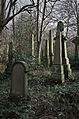
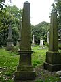
Dalry Cemetery
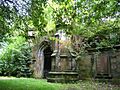
Dalry Cemetery was designed in 1846 by David Cousin. It was built to serve the southwest parts of the city. The cemetery is about 6 acres, making it one of Edinburgh's smaller cemeteries. A lodge house was added in 1873. An old Gothic entrance arch was taken down in the 1900s.
The cemetery was used most often in the 1800s. However, it is also the resting place for 24 people who died in the First World War and 2 from the Second World War. By the 1970s, the cemetery was in bad shape. A group called 'Action for Dalry Cemetery Group' helped clean it up. In 1987, Edinburgh Council took over the cemetery, and after more work, it reopened in 1991.
Next to the cemetery is a long, steep path called 'Coffin Lane.' This lane has high walls on both sides. It has been mentioned in several mystery books, including the Rebus novel Let It Bleed by Ian Rankin. The novel Crime by Irvine Welsh also mentions Dalry.
Images for kids
-
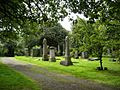
A view of Dalry Cemetery.
-
Another view of Dalry Cemetery.
-
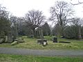
A path inside Dalry Cemetery.
-
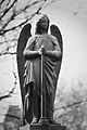
An angel statue in Dalry Cemetery.
-
A monument in Dalry Cemetery.
-
An old family tombstone.


.jpg)
.jpg)

