Dante, Virginia facts for kids
Quick facts for kids
Dante, Virginia
|
|
|---|---|

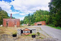
Welcome sign along Bunch Town Road
|
|
| Country | United States |
| State | Virginia |
| County | Russell |
| Area | |
| • Total | 7.02 sq mi (18.17 km2) |
| • Land | 7.01 sq mi (18.15 km2) |
| • Water | 0.008 sq mi (0.02 km2) |
| Elevation | 1,765 ft (538 m) |
| Population
(2010)
|
|
| • Total | 649 |
| • Density | 93/sq mi (35.8/km2) |
| Time zone | UTC−5 (Eastern (EST)) |
| • Summer (DST) | UTC−4 (EDT) |
| ZIP code |
24237
|
| FIPS code | 51-21312 |
| GNIS feature ID | 2630763 |
| Website | http://danteva.org/ |
Dante is a small community located in both Russell and Dickenson counties in Virginia, United States. It is known as a census-designated place, which means it's a special area counted by the census bureau. In 2010, about 649 people lived there. Dante is famous for its past as a coal mining town and its current efforts to bring new life to the area.
Contents
History of Dante, Virginia
Dante was first called "Turkeyfoot." This name came from the way several hollows (small valleys) met there, looking a bit like a turkey's foot. People started settling in this area in the late 1700s and early 1800s. These early settlers were frontiersmen moving west.
Coal Mining Boom in Dante
Dante grew very quickly in the early 1900s. This was because a lot of coal was found nearby. A businessman named George Lafayette Carter was very important to Dante's growth. He made Dante the northern end of the Clinchfield Railroad. He also made it the main office for the Clinchfield Coal Company. This company started mining coal in nearby areas like Bear Wallow and Straight Hollow.
Because of the coal mines, many immigrants came to Dante. They arrived from countries like Germany, Hungary, Greece, and Poland. In 1912, a big project called the Sandy Ridge Tunnel was finished. This tunnel was just north of Dante. It allowed the Clinchfield Railroad to reach all the way to Elkhorn City, Kentucky.
Changes After the Coal Era
The coal in the mines around Dante started to run out by the mid-1960s. Because of this, the mines in Dante closed. New mines, like Moss #3 in Duty, Virginia, opened instead. For many years, Dante was a quiet town that had seen better days.
However, things began to change in 2016. People who lived in Dante became interested in making their community better. They started talking about ways to bring new life to the town. Part of this plan includes opening a general store again. They also want to turn old railroad tracks and mine paths into trails for ATVs. The CSX Transportation company stopped its rail operations in Dante in 2015. The old Clinchfield Coal Company offices are now apartments.
Revitalization Efforts in Dante
In early 2016, the Dante Community Association was created. This group includes citizens from Dante and representatives from Russell County. The main goal of this organization is to help Dante and the areas around it grow and improve.
They plan to do this by investing in several areas. These include improving the town's basic services and buildings, known as infrastructure. They also want to help the local economy grow. The association is working to get a grant to help with their planning.
Geography of Dante
Dante is located in the northwestern part of Russell County. The area known as Dante also stretches west into Dickenson County. This part includes a small settlement called West Dante.
Waterways and Land Features
The communities of Dante are in the valley of Lick Creek. This creek flows south and eventually joins the Clinch River near St. Paul. The Clinch River is part of the larger Tennessee River watershed. This means that water from Lick Creek eventually flows into the Tennessee River.
To the north of Dante is Sandy Ridge. This ridge is part of the Tennessee Valley Divide. Water on one side of the ridge flows north. It goes through the McClure River to the Russell Fork and Levisa Fork. These rivers then join the Big Sandy River system. This system eventually reaches the Ohio River near Huntington, West Virginia.
Dante is about 7.5 miles (12.1 km) north of St. Paul. It is also about 21 miles (34 km) south of Clinchco. You can reach these places by taking Virginia State Route 63.
Climate in Dante
The climate in Dante is known for its hot and humid summers. The winters are usually mild to cool. According to the Köppen Climate Classification system, Dante has a humid subtropical climate. This type of climate is often shown as "Cfa" on climate maps.
See also
 In Spanish: Dante (Virginia) para niños


