Darfur, Minnesota facts for kids
Quick facts for kids
Darfur
|
|
|---|---|
|
City
|
|

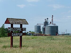
Town sign and grain elevator in Darfur, Minnesota
|
|

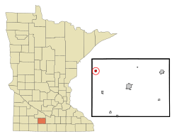
Location of Darfur, Minnesota
|
|
| Country | United States |
| State | Minnesota |
| County | Watonwan |
| Government | |
| • Type | Mayor – Council |
| Area | |
| • Total | 0.23 sq mi (0.59 km2) |
| • Land | 0.23 sq mi (0.59 km2) |
| • Water | 0.00 sq mi (0.00 km2) |
| Elevation | 1,148 ft (350 m) |
| Population
(2020)
|
|
| • Total | 84 |
| • Density | 366.81/sq mi (141.49/km2) |
| Time zone | UTC-6 (Central (CST)) |
| • Summer (DST) | UTC-5 (CDT) |
| ZIP code |
56022
|
| Area code(s) | 507 |
| FIPS code | 27-14770 |
| GNIS feature ID | 2393719 |
Darfur is a small city in Watonwan County, Minnesota, United States. It's located in the southern part of Minnesota. In 2020, about 84 people lived there.
Contents
Where is Darfur, Minnesota?
Darfur is a small place, covering about 0.59 square kilometers (or 0.23 square miles). That's all land, with no lakes or rivers inside the city limits.
A main road, Minnesota State Highway 30, goes through the community. This highway helps people travel to and from Darfur.
A Look at Darfur's History
Darfur was first planned out in April 1899 by a company called the Chicago and North Western Railway. This means they laid out the streets and lots for the future town.
It officially became a village on December 31, 1903. Later, on January 1, 1974, it changed from a village to a city. This happened when Minnesota decided to call all its villages "cities."
How Darfur Got Its Name
The name "Darfur" has an interesting story! According to a historian named Warren Upham, the city might have been named after a region in Sudan, a country in Africa.
Another idea is that two railroad workers from Scandinavia were talking. One asked, "Why you stop dar fur?" (meaning "Why are you stopping there for?"). This funny question might have inspired the name!
Who Lives in Darfur?
The number of people living in Darfur has changed over the years. Here's a quick look at the population from different years:
| Historical population | |||
|---|---|---|---|
| Census | Pop. | %± | |
| 1910 | 72 | — | |
| 1920 | 112 | 55.6% | |
| 1930 | 101 | −9.8% | |
| 1940 | 132 | 30.7% | |
| 1950 | 150 | 13.6% | |
| 1960 | 191 | 27.3% | |
| 1970 | 179 | −6.3% | |
| 1980 | 139 | −22.3% | |
| 1990 | 128 | −7.9% | |
| 2000 | 137 | 7.0% | |
| 2010 | 108 | −21.2% | |
| 2020 | 84 | −22.2% | |
| U.S. Decennial Census | |||
Darfur's Population in 2010
In 2010, the census counted 108 people living in Darfur. These people lived in 49 different homes. About 30 of these homes were families.
Most of the people (94.4%) were White. A small number (3.7%) were from other races, and 1.9% were from two or more races. About 9.3% of the people identified as Hispanic or Latino.
The average age of people in Darfur in 2010 was about 45.5 years old.
- About 23.1% of residents were under 18 years old.
- About 19.4% were 65 years old or older.
- The rest were between 18 and 64 years old.
The city had a nearly even number of males and females. About 50.9% were male, and 49.1% were female.
See also
 In Spanish: Darfur (Minnesota) para niños
 | Dorothy Vaughan |
 | Charles Henry Turner |
 | Hildrus Poindexter |
 | Henry Cecil McBay |

