
Darfur facts for kids
Quick facts for kids
Darfur
دار فور
|
|
|---|---|
 |
|
| Capital | Al-Fashir |
| Official languages | Arabic, Fur |
| Demonym(s) | Darfuri, Darfurian and Darfurese |
| Area | |
|
• Total
|
493,180 km2 (190,420 sq mi) |
| Population | |
|
• 2017 estimate
|
9,241,369 |
|
• Density
|
18.7/km2 (48.4/sq mi) |
| Currency | Sudanese pound |
| Time zone | UTC+2:00 (EAT) |
Darfur (which means "home of the Fur" in Arabic) is a large region in the far western part of Sudan. It shares borders with countries like the Central African Republic, Libya, and Chad. Darfur is split into three main states: West Darfur, South Darfur, and North Darfur. For many years, the region has faced a difficult situation due to conflicts between different groups. This has led to a major humanitarian crisis, meaning many people need help and support.
Contents
Geography and Climate of Darfur

Darfur covers a huge area, about 493,180 square kilometers (196,555 square miles). That's bigger than half the size of Kenya! The land is mostly a dry, flat area called an arid plateau. In the middle of Darfur, you'll find the Marrah Mountains (Jebel Marra). These are volcanic peaks that reach up to 3,000 meters (10,100 feet) high. The main towns in the region are Al Fashir, Nyala, and Geneina.
There are four main types of land in Darfur. The eastern half has flat plains and low hills made of sandy soil, known as goz. In many places, the goz has no water, so people can only live there if they have water tanks or deep wells. To the north, the goz turns into the desert sands of the Sahara.
The second type of land is wadis. These are riverbeds that only have water during the rainy season. Some are small streams, while others are large and flow for hundreds of miles west towards Lake Chad. Many wadis have rich soil that is good for farming.
The western part of Darfur is mostly made of basement rock. This rock is not good for farming, but it does have some forests where animals can graze.
The fourth and final type of land is the Marrah Mountains. The highest point is at Deriba crater, where the climate is cooler, there's more rain, and water springs flow all year.
The rainy season in Darfur is from June to September. During this time, the dry brown land turns green. Rain is very important because most people in Darfur are farmers. In a normal year, crops are ready to be picked by November. After harvest, the dry plant stalks can be used to feed farm animals. In the far northern desert, it can go many years without rain. But in the far south, it rains about 700 millimeters (27 inches) each year, and many trees stay green all year long.
Economy and People

Darfur has about 7.4 million people living there. Most of Darfur's economy relies on subsistence agriculture. This means people grow just enough food to feed themselves and their families. They grow cereals, fruit, and tobacco. In the drier northern parts, people also raise livestock like cattle.
Darfur often experiences dry periods (droughts) in the summer and heavy rains in the winter. These weather changes can make it hard for farmers to grow enough crops. Sometimes, this has led to food shortages, causing many people to suffer.
The Conflict in Darfur
A major armed conflict started in the Darfur region of Sudan in February 2003. Two rebel groups, the Sudan Liberation Movement (SLM) and the Justice and Equality Movement (JEM), began fighting against the government of Sudan. They felt that the government was not treating the non-Arab population of Darfur fairly.
The fighting caused a lot of suffering for many people in Darfur. Hundreds of thousands of civilians died, either from the conflict itself or from hunger and illness. Millions of people were forced to leave their homes and move to refugee camps or across the border into other countries. This created a serious humanitarian crisis, where many people needed urgent help.
To try and end the fighting, a peace agreement was signed on August 31, 2020. This agreement was made between the Sudanese authorities and several of the rebel groups. The goal was to stop the armed conflict and bring peace to the region.
Images for kids
-
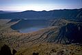
Deriba Crater is at the highest point of the Marrah Mountains
-
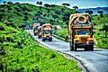
Overland trucks en route near Jebel Marra, 2019
-
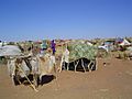
Camp of Darfuris internally displaced by the ongoing War in Darfur.
-
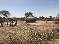
A village in South Darfur
-
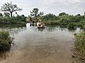
A villager in Darfur, Sudan, crosses the overflowing stream.
-
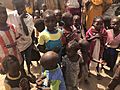
Sudanese children in an IDP camp in Darfur.


See also
 In Spanish: Darfur para niños
