Dawson, Pennsylvania facts for kids
Quick facts for kids
Dawson, Pennsylvania
|
|
|---|---|
|
Borough
|
|

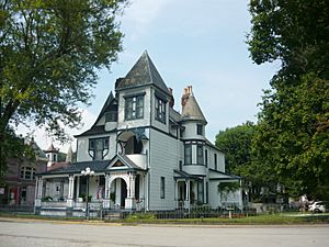
James Cochran House (1890)
|
|

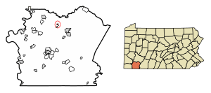
Location of Dawson in Fayette County, Pennsylvania.
|
|
| Country | United States |
| State | Pennsylvania |
| County | Fayette |
| Established | 1866 |
| Area | |
| • Total | 0.21 sq mi (0.55 km2) |
| • Land | 0.17 sq mi (0.45 km2) |
| • Water | 0.04 sq mi (0.11 km2) |
| Population
(2020)
|
|
| • Total | 352 |
| • Density | 2,034.68/sq mi (785.71/km2) |
| Time zone | UTC-4 (EST) |
| • Summer (DST) | UTC-5 (EDT) |
| Area code(s) | 724 |
Dawson is a small town, also known as a borough, in Fayette County, Pennsylvania, United States. In 2020, about 352 people lived there. This number was a little smaller than in 2010, when 367 people called Dawson home.
Contents
Where is Dawson Located?
Dawson is in the northern part of Fayette County. It sits right on the north bank of the Youghiogheny River. You can find its exact spot using these coordinates: 40°2′52″N 79°39′31″W / 40.04778°N 79.65861°W.
Pennsylvania Route 819 goes through the middle of Dawson. This road crosses the Youghiogheny River to a nearby area called Liberty. If you follow PA 819 northeast for about 6 miles, you'll reach Scottdale. Going south for about 1 mile will take you to Vanderbilt. The city of Connellsville is about 5.5 miles southeast, reachable by PA 819 and PA 201.
The United States Census Bureau says Dawson covers about 0.21 square miles in total. Most of this area, about 0.16 square miles, is land. The rest, about 0.05 square miles, is water. A small stream called Smiley Run also flows into the Youghiogheny River on the west side of town.
Dawson's Neighbors
Dawson shares its land borders with only one place: Lower Tyrone Township. This township is to Dawson's north, east, and west. Across the Youghiogheny River to the south, Dawson is next to Dunbar Township.
People Living in Dawson
The number of people living in Dawson has changed over the years. Here's how the population has looked:
| Historical population | |||
|---|---|---|---|
| Census | Pop. | %± | |
| 1880 | 453 | — | |
| 1890 | 668 | 47.5% | |
| 1900 | 825 | 23.5% | |
| 1910 | 848 | 2.8% | |
| 1920 | 956 | 12.7% | |
| 1930 | 800 | −16.3% | |
| 1940 | 732 | −8.5% | |
| 1950 | 723 | −1.2% | |
| 1960 | 707 | −2.2% | |
| 1970 | 676 | −4.4% | |
| 1980 | 661 | −2.2% | |
| 1990 | 535 | −19.1% | |
| 2000 | 451 | −15.7% | |
| 2010 | 367 | −18.6% | |
| 2020 | 352 | −4.1% | |
| 2021 (est.) | 347 | −5.4% | |
| Sources: | |||
In 2000, there were 451 people living in Dawson. These people made up 183 households, and 120 of these were families. Most people in Dawson were White (99.78%).
About 27.9% of households had children under 18 living with them. Many households (53.6%) were married couples. The average household had about 2.46 people.
The median age in Dawson in 2000 was 38 years old. This means half the people were younger than 38 and half were older. About 24.4% of the population was under 18.
The median income for a household in Dawson was $27,500. This means half the households earned more than this, and half earned less. About 16.4% of all people in Dawson lived below the poverty line. This included 23.7% of children under 18.
Important Places in Dawson
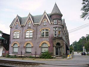
Dawson has some special places that are listed on the National Register of Historic Places. These include the Dawson Historic District and the Philip G. Cochran Memorial United Methodist Church. The church is built in a beautiful Gothic style.
Education in Dawson
Students in Dawson attend schools that are part of the Connellsville Area School District.
Town Services
The town of Dawson gets its sewage treatment services from the Yough Sanitary Authority.
A Look at Dawson's History
The land where Dawson now stands once belonged to a man named John Smilie. He was an important person in Pennsylvania's government and even served in the U.S. Congress. After he passed away in 1812, his land was held in a trust. It wasn't until his last child died in 1851 that the property was sold.
The flat land near the river, often called "bottom land," was bought by John Smilie's granddaughter, Sarah Huston Dawson, and her husband, George Dawson. They used this land for farming.
Later, the Pittsburgh and Connellsville Railroad built tracks through this area. A train stop called Dawson's Station was set up, and a post office opened at the same time.
The property eventually went to Mrs. Alfred Howell, whose maiden name was Elizabeth Dawson. In 1866, her husband, Alfred Howell, had the land surveyed and divided into building lots. Thanks to his planning and hard work, a successful village grew there in just a few years. This new village had churches and public schools, turning what was once just an old farm into a thriving community.
See also
 In Spanish: Dawson (Pensilvania) para niños
 | May Edward Chinn |
 | Rebecca Cole |
 | Alexa Canady |
 | Dorothy Lavinia Brown |


