
Scottdale, Pennsylvania facts for kids
Quick facts for kids
Scottdale, Pennsylvania
|
|
|---|---|
|
Borough
|
|

Pittsburgh Street in Downtown Scottdale
|
|

Location of Scottdale in Westmoreland County, Pennsylvania
|
|

Scottdale, Pennsylvania
Location in Pennsylvania
|
|
| Country | United States |
| State | Pennsylvania |
| County | Westmoreland |
| Settled | 1872 |
| Incorporated | 1874 |
| Government | |
| • Type | Borough Council |
| Area | |
| • Total | 1.16 sq mi (3.00 km2) |
| • Land | 1.16 sq mi (3.00 km2) |
| • Water | 0.00 sq mi (0.00 km2) |
| Elevation | 1,020 ft (310 m) |
| Population
(2010)
|
|
| • Total | 4,384 |
| • Estimate
(2019)
|
4,094 |
| • Density | 3,535.41/sq mi (1,365.30/km2) |
| Time zone | UTC-5 (Eastern (EST)) |
| • Summer (DST) | UTC-4 (EDT) |
| Zip Code |
15683
|
| FIPS code | 42-68432 |
| Website | Scottdale Chamber of Commerce |
Scottdale is a small town, called a borough, in Westmoreland County, Pennsylvania, United States. It is about 32 miles (51 km) southeast of Pittsburgh.
In the early 1900s, Scottdale was a big center for making coke, which is a fuel made from coal. This was thanks to Henry Clay Frick's companies. The town also had factories that made steel, iron pipes, and other metal items. Today, most of these old factories are closed. Scottdale has changed from a busy industrial town to a quieter place, like many other towns in the "Rust Belt" region. Duraloy Technologies, a company that makes special metal parts, is one of the last businesses from Scottdale's industrial past.
In 1900, about 4,261 people lived in Scottdale. By 1940, the population grew to 6,493. In 2010, the population was 4,384. Scottdale is part of the Southmoreland School District.
Contents
Scottdale's History: From Mills to Modern Times
How Scottdale Began: Early Settlers and Railroads
It's hard to know exactly when the first non-Native American settlers arrived in the area that is now Scottdale. However, many Scotch-Irish immigrants moved here in the late 1770s. In the mid-1800s, part of the town was known as Fountain Mills. It had a distillery, a flour mill, and a post office.
The Pennsylvania Railroad and Baltimore and Ohio Railroad built train lines through the community in the early 1870s. This changed the local economy from farming to making things and mining. Two local farmers, Peter and Jacob Loucks, saw how important the railroads would be. They planned out a small town with 24 lots, which went on sale in 1872.
The borough was first called Fountain Mills because of the mills in the area. Scottdale officially became a borough on February 5, 1874. It was named after Thomas A. Scott, who was the president of the Pennsylvania Railroad and served in the government during the Civil War.
Because Scottdale sits on top of large coal deposits, the town grew quickly. The surrounding coal mines and ovens that turned coal into coke (fuel) made it prosperous. The H. C. Frick Coke Company, owned by Henry Clay Frick, had its main office here. In the early 1900s, Scottdale's factories also made iron pipes, tin, knives, steam engines, and caskets.
Scottdale has two places listed on the National Register of Historic Places. These are the Scottdale Armory (built in 1929) and the Scottdale Historic District. The historic district includes the oldest parts of the borough.
The oldest building still standing in Scottdale is the Jacob Loucks House at 115 Walnut Avenue, built in 1853. Many other old homes from the 1880s are on Loucks Avenue. Also, three downtown shops built around 1880 are at 101 Pittsburgh Street, 143 Pittsburgh Street, and 4-10 South Broadway Street.
The West Overton Museum in Scottdale is a unique place. It's the only pre-Civil War village in Pennsylvania that is still complete. It was added to the National Register of Historic Districts in 1985. It shows what a 19th-century rural industrial village was like, with a farm, the Overholt Mill/Distillery, old tools, a Blacksmith Shop, a wash house, and a smokehouse. It is also a stop on the American Whiskey Trail.
Scottdale's Growth: From Coke to Culture (1900-1968)
In the early 1900s, Scottdale was home to 30,000 coke ovens. Many mining companies used these ovens because Scottdale's location on the Pennsylvania Railroad allowed them to ship coal and coke across the United States. The Great Depression in 1929 caused many of these mines to close.
After the Great Depression, new industries started to appear. One important company, Duraloy Technologies, opened in the 1920s. Duraloy was the first company in the United States to create special metals that could resist heat, used for making metal products. The company is still open in its original building today.
In 1900, The Geyer Performing Arts Center opened on Pittsburgh Street. It was first an opera house and hosted vaudeville shows. In 1912, it was sold and became The Scottdale Theater, showing movies. It changed hands again in 1926 and was renamed The Strand. The Strand was one of the first theaters to show movies with sound. It closed in 1969. When it reopened in April 1987, it started hosting live stage performances, which it still does. The Geyer also hosts stand-up comedy and concerts.
Scottdale's Changes: Mall Plans and New Beginnings (1969-Present)
In 1969, Scottdale tried to build a shopping mall in downtown Scottdale. It was planned for Pittsburgh and North Broadway Streets, with a gas station next door. New sidewalks, wiring, and sewer lines were put in by June 1970 to get the site ready.
By December 1970, the area was still not built. Many businesses on Pittsburgh Street had been torn down for the mall. The roads to access the area were not paved. Only one company had agreed to open a business in the plaza, which was for the gas station. Funding for the project started to run out. Scottdale's town council refused to give more money until more businesses showed interest. A budget for a parking lot was approved in December 1971.
The mall project continued to develop into September 1972, with one more business showing interest. Finally, in October 1974, the borough signed a contract with a company from Uniontown to start building. But by 1975, the mall project stopped completely after six years.
On May 1, 1976, the area where the mall was supposed to be became a park. A gazebo and three flagpoles were put in the park. A walkway was also added to reach the park from Pittsburgh Street. In the years since the failed mall project, Scottdale has opened a Rite-Aid Pharmacy, a YMCA Pool, a public library, and a Veteran Memorial in this area.
Scottdale also uses this space every year for its Fall Festival. Since 1973, the Scottdale Fall Festival has featured many outdoor vendors, music performances, and a yearly parade. Local businesses and high school groups, like the Southmoreland football team and marching band, take part in the parade. The Fall Festival is also where Southmoreland High School's homecoming king and queen are crowned.
After the mall project failed, Scottdale has seen some economic challenges. As of 2022, about 2,000 residents are employed, mostly in healthcare or retail. About 14.3% of Scottdale residents live below the poverty line. The average household income is just over $53,000. The unemployment rate is 7.4%, which is higher than the national average.
In 2022, the old Greystone Manor building was bought. This building, built in 1905, was once a department store. It had been empty for decades and was falling apart. With the purchase, $2 million has been spent to fix up and restore the building.
Learning in Scottdale: Schools and Education
In 1805, the first schoolhouse in the area was built near Gaut’s Dairy Farm in rural Scottdale. The first school board for the district was created on September 19, 1834. The school district grew, and more buildings were added. Later, it split into two districts: Scottdale School District and East Huntingdon School District.
The Scottdale school district opened several schools throughout the borough, including North, Central, and South grade schools. The first high school building was built in the late 1800s where Chestnut Street Park is now. This building was torn down in 1901 and a new school building was built across the street in the same year. With the new school, Scottdale's students became known as the "Scotties." They started using the Scottish Terrier as their mascot and chose white and blue as their colors. A football field was built behind the school, leading to the school starting sports teams.
By the 1952 school year, Scottdale High School was getting too small for the number of students. It also merged with the nearby Upper Tyrone School District. This led to a new building being planned. The new site for the renamed Scottdale Joint High School was bought on June 22, 1953. The building was first used for a Scotties basketball game in January 1958. The school officially opened for classes on September 3, 1958.
In the fall of 1964, Scottdale and the nearby East Huntingdon School District joined together to form the Southmoreland School District. Students from Scottdale Joint High School now attend classes at Southmoreland High School in Alverton. The old Scottdale Joint High School building was renovated in 2010 and is now Southmoreland Elementary and Middle School.
Scottdale's Location: Geography and Nearby Areas
Scottdale is located at 40°6′55″N 79°35′59″W / 40.11528°N 79.59972°W.
The United States Census Bureau says the borough covers a total area of about 1.2 square miles (3.0 km2), all of which is land.
Some cities and towns near Scottdale include Pittsburgh (32 miles northwest), Connellsville (6.0 miles south), Dawson (6.0 miles southwest), Everson (0.9 miles south), Hunker (7.3 miles north), Mount Pleasant (4.7 miles northeast), New Stanton (8.2 miles north), South Connellsville (7.2 miles south), and Vanderbilt (6.9 miles southwest). It is also 38 miles northeast of Morgantown, West Virginia.
Jacob's Creek forms the border between Westmoreland and Fayette County, separating Scottdale and Everson.
Scottdale's Neighborhoods
Scottdale has three borders. It borders East Huntingdon to the north, northwest, and west. It also borders the Fayette County areas of Upper Tyrone Township from the east-northeast to the south, and Everson to the south.
There are several neighborhoods within the borough itself. North Scottdale is on the north side of Pittsburgh Street. It is home to the abandoned Wyndon Links golf course. South Scottdale starts at South Broadway Street and goes down to Creek Road. The neighborhood just past the Everson bridge, from Garfield Avenue to Scottdale Cemetery, is known locally as “Brown Town.”
Who Lives in Scottdale: Demographics
| Historical population | |||
|---|---|---|---|
| Census | Pop. | %± | |
| 1880 | 1,275 | — | |
| 1890 | 2,693 | 111.2% | |
| 1900 | 4,261 | 58.2% | |
| 1910 | 5,456 | 28.0% | |
| 1920 | 5,768 | 5.7% | |
| 1930 | 6,714 | 16.4% | |
| 1940 | 6,493 | −3.3% | |
| 1950 | 6,249 | −3.8% | |
| 1960 | 6,244 | −0.1% | |
| 1970 | 5,818 | −6.8% | |
| 1980 | 5,833 | 0.3% | |
| 1990 | 5,184 | −11.1% | |
| 2000 | 4,772 | −7.9% | |
| 2010 | 4,384 | −8.1% | |
| 2020 | 4,430 | 1.0% | |
| Sources: | |||
Based on the census from 2000, there were 4,772 people living in Scottdale. These people lived in 2,034 households, and 1,309 of these were families. The population density was about 4,095 people per square mile (1,581 people per square kilometer). There were 2,214 housing units, with an average of about 1,900 units per square mile (733 per square kilometer). Most residents were White (98.13%), with smaller percentages of African American, Native American, Asian, Pacific Islander, and people of two or more races. About 0.36% of the population was Hispanic or Latino.
Out of the 2,034 households, 26.2% had children under 18 living with them. About 51.3% were married couples living together. About 10.3% had a female head of household with no husband present. And 35.6% were not families. About 32.7% of all households were made up of individuals, and 17.9% had someone living alone who was 65 years old or older. The average household size was 2.31 people, and the average family size was 2.94 people.
The population was spread out by age. About 21.2% were under 18 years old. About 7.1% were between 18 and 24. About 26.5% were between 25 and 44. About 24.4% were between 45 and 64. And 20.8% were 65 years old or older. The average age was 42 years. For every 100 females, there were about 87.1 males. For every 100 females aged 18 and over, there were about 84.2 males.
The average income for a household in the borough was $32,000. For a family, the average income was $41,114. Men had an average income of $31,843, while women had an average income of $22,143. The average income per person in the borough was $17,994. About 5.2% of families and 8.3% of the total population lived below the poverty line. This included 8.9% of those under 18 and 7.8% of those 65 or older.
When it comes to education, 87.2% of residents had a high school diploma or higher. About 18.3% had a Bachelor's Degree or higher. And 6.2% had a Graduate or Professional Degree.
The main ancestries of the residents were: 35.7% German, 12% Polish, 11.8% Irish, 10.5% Italian, 10.3% English, and 4.6% Scottish.
Famous People from Scottdale
- Johnny Arthur – A stage and film actor.
- D. J. Coffman – A comic book illustrator and cartoonist.
- Leonard Goldenson – The former president of the American Broadcasting Company.
- Russ Grimm – A former professional football player for the Washington Redskins. He won three Super Bowls and is in the Pro Football Hall of Fame.
- Jim Heise – A former professional baseball player for the Washington Senators.
- Abraham Lincoln Keister – A former U.S. Congressman.
- Herbert Morrison – A radio announcer famous for reporting on the Hindenburg disaster in 1937.
- Jack Onslow – A former professional baseball player for the Detroit Tigers and New York Giants.
- Lillian Peacock – A silent film actress.
- Walter E. "Jack" Rollins – A former musician.
- Chris Shipley – A technology industry expert and commentator.
Images for kids
-
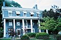
Jacob Loucks House, built in 1853, Scottdale's oldest building
-
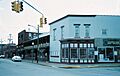
Historic buildings at the corner of Pittsburgh and South Broadway streets, around 1890
-
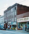
Central Hotel, around 1910
-
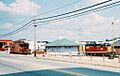
The Scottdale train station
-
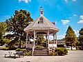
The gazebo in downtown Scottdale, built in 1976.
-
Banner celebrating Scottdale’s 150th anniversary above Pittsburgh Street.
-
Scottdale High School building, 1901
-
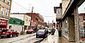
Pittsburgh Street in Scottdale, facing west.


See also
 In Spanish: Scottdale (Pensilvania) para niños
