Dayton, Alabama facts for kids
Quick facts for kids
Dayton, Alabama
|
|
|---|---|

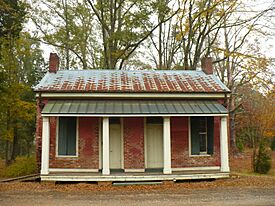
The Boddie law office, now the Dayton Town Hall, completed in 1858
|
|

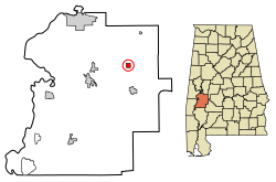
Location in Marengo County, Alabama
|
|
| Country | United States |
| State | Alabama |
| County | Marengo |
| Incorporated | January 13, 1844 |
| Area | |
| • Total | 1.00 sq mi (2.59 km2) |
| • Land | 1.00 sq mi (2.59 km2) |
| • Water | 0.00 sq mi (0.00 km2) |
| Elevation | 243 ft (74 m) |
| Population
(2020)
|
|
| • Total | 28 |
| • Estimate
(2022)
|
27 |
| • Density | 27.0/sq mi (10.44/km2) |
| Time zone | UTC−6 (Central (CST)) |
| • Summer (DST) | UTC−5 (CDT) |
| ZIP Code |
36738
|
| Area code(s) | 334 |
| FIPS code | 01-19912 |
| GNIS feature ID | 0117151 |
Dayton is a small town located in Marengo County, Alabama, in the United States. In 2020, the town had a population of 28 people.
Contents
History of Dayton
Dayton started to be settled in the early 1800s. A survey of the town was completed in 1832, and a public well was set up. The town's post office opened in 1837. Dayton officially became a town on January 13, 1844.
In 1852, a powerful tornado struck the town. By 1860, Dayton was a busy place. It had schools for boys and girls, a hotel, and businesses like a cotton gin (a machine that separates cotton fibers from seeds). There was also an oil mill, a blacksmith shop, a tavern, a cabinet shop, a drug store, and several general stores. Many large homes were built, but most are now gone. The William Poole House is one of the surviving homes and is listed on the National Register of Historic Places.
Over the last century, less farming has happened in the area. This has caused the town's population to become much smaller than it once was.
Geography of Dayton
Dayton is located in the northeastern part of Marengo County. Its exact location is 32°20′59″N 87°38′28″W / 32.34972°N 87.64111°W. It is about 11 miles (18 km) northeast of Linden, which is the main town of the county. Dayton is also about 20 miles (32 km) southeast of Demopolis, the biggest city in Marengo County.
The United States Census Bureau says that Dayton covers a total area of 1.0 square mile (2.59 square kilometers). All of this area is land. The town is built on a ridge. Water from this ridge flows southeast into Dry Creek and northwest into Little Dry Creek. Both of these creeks flow into Chickasaw Bogue, which then flows west to the Tombigbee River.
Population Changes in Dayton
| Historical population | |||
|---|---|---|---|
| Census | Pop. | %± | |
| 1870 | 426 | — | |
| 1880 | 473 | 11.0% | |
| 1890 | 412 | −12.9% | |
| 1900 | 427 | 3.6% | |
| 1910 | 382 | −10.5% | |
| 1920 | 245 | −35.9% | |
| 1930 | 202 | −17.6% | |
| 1940 | 153 | −24.3% | |
| 1950 | 85 | −44.4% | |
| 1960 | 99 | 16.5% | |
| 1970 | 115 | 16.2% | |
| 1980 | 113 | −1.7% | |
| 1990 | 77 | −31.9% | |
| 2000 | 60 | −22.1% | |
| 2010 | 52 | −13.3% | |
| 2020 | 28 | −46.2% | |
| 2022 (est.) | 27 | −48.1% | |
| U.S. Decennial Census 2020 Census |
|||
According to the 2020 census, there were 28 people living in Dayton. There were 7 households and 4 families in the town. The town also had 12 housing units.
Climate in Dayton
The weather in Dayton has hot and humid summers. The winters are usually mild to cool. This type of weather is known as a humid subtropical climate. On climate maps, it is often shown as "Cfa."
Famous People from Dayton
- Sarah Byrd Askew: A public librarian who helped start many county libraries in the United States.
- Bill Poole: A politician.
See also
 In Spanish: Dayton (Alabama) para niños
 | Roy Wilkins |
 | John Lewis |
 | Linda Carol Brown |


