De La Galette Lake facts for kids
Quick facts for kids De La Galette Lake |
|
|---|---|

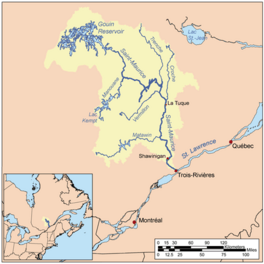
Watershed of Saint-Maurice River
|
|
| Location | La Tuque |
| Coordinates | 48°17′25″N 74°27′27″W / 48.29028°N 74.45750°W |
| Type | Natural |
| Primary inflows |
|
| Primary outflows | Gouin Reservoir. |
| Basin countries | Canada |
| Max. length | 7.8 kilometres (4.8 mi) |
| Max. width | 2.4 kilometres (1.5 mi) |
| Surface elevation | 402 metres (1,319 ft) |
Lac de la Galette (which means "De La Galette Lake" in English) is a freshwater lake in the town of La Tuque, Quebec, Canada. It's a large bay on the south side of the Gouin Reservoir, located west of the upper Saint-Maurice River.
This lake is mostly in the Delage area. A part of its eastern shore reaches into the Leblanc area. The Leblanc River (Gouin Reservoir) flows into this eastern bay. After the Gouin Dam was built in 1948, Lac de la Galette became an extension of Bouzanquet Bay. This bay is itself an extension of the much larger Gouin Reservoir.
The main activity around the lake is forestry, which means cutting down trees for wood. Recreational tourism is also popular. People enjoy visiting the area for fun activities like fishing or boating.
Quebec route 400 is a road that helps people get to the lake. It connects the Gouin Dam to the village of Parent, Quebec. This road also goes along the De La Galette River (Gouin Reservoir) and the Leblanc River (Gouin Reservoir) valleys. The road also serves a long piece of land that sticks out into the Gouin Reservoir. There are also smaller forest roads used for logging and tourism.
The surface of De La Galette Lake usually freezes over from mid-November until the end of April. However, it's generally safe to walk or drive on the ice from early December to late March.
Exploring De La Galette Lake
This lake has a unique banana shape, stretching about 7.8 kilometres (4.8 mi) long. At its widest point, it measures about 2.4 kilometres (1.5 mi). The lake sits at an elevation of 402 metres (1,319 ft) above sea level. This is the same water level as the Gouin Reservoir it connects to.
Lac de la Galette has a somewhat complicated shape. It includes a peninsula, which is a piece of land almost surrounded by water. This peninsula stretches eastward for about 1.7 kilometres (1.1 mi). There's a mountain peak nearby, about 1.9 kilometres (1.2 mi) east of where the peninsula connects to the lake's western shore. This mountain reaches 517 metres (1,696 ft) high.
Several rivers and streams flow into Lac de la Galette. From the southeast, it receives water from the Leblanc River (Gouin Reservoir). From the south, it gets water from the De La Galette River (Gouin Reservoir). Also, water from Lake Delage flows into the southwest part of the lake.
Where the Lake Connects to Other Waters
The mouth of Lac de la Galette is where its water flows out. This point is about 27.8 kilometres (17.3 mi) southwest of the Gouin Dam. It's also about 52.1 kilometres (32.4 mi) southeast of the village of Obedjiwan, Quebec. The village of Wemotaci, Quebec is about 68.7 kilometres (42.7 mi) northwest of the lake.
From the mouth of Lac de la Galette, the water flows into the Gouin Reservoir. It travels northwest into Bouzanquet Bay. Then, the current crosses the large Gouin Reservoir, going around a big peninsula. It continues through Brochu Lake and Kikendatch Bay until it reaches the Gouin Dam. From the dam, the water then flows down the Saint-Maurice River all the way to Trois-Rivières.
Naming the Lake
The name "Lac de la Galette" was officially recognized on December 18, 1986. This was done by the Commission de toponymie du Québec, which is the organization responsible for naming places in Quebec.
 | Toni Morrison |
 | Barack Obama |
 | Martin Luther King Jr. |
 | Ralph Bunche |


