Kikendatch Bay facts for kids
Quick facts for kids Kikendatch Bay |
|
|---|---|

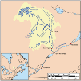
Watershed of Saint-Maurice River
|
|
| Location | La Tuque |
| Coordinates | 48°22′17″N 74°10′10″W / 48.37139°N 74.16944°W |
| Type | Natural |
| Primary inflows | Brochu Lake, Gouin Reservoir |
| Primary outflows | Saint-Maurice River (via Gouin Dam) |
| Basin countries | Canada |
| Max. length | 13.4 kilometres (8.3 mi) |
| Max. width | 4.2 kilometres (2.6 mi) |
| Surface elevation | 402 metres (1,319 ft) |
The Kikendatch Bay is a large body of fresh water in Quebec, Canada. It connects to the huge Gouin Reservoir. This bay is located in the area of La Tuque, which is part of the Mauricie region.
Most of the bay is in a specific land area called Levasseur township. In 1948, the Gouin Dam was finished. After the dam was built, Kikendatch Bay became an extension of Brochu Lake, which is to the northwest. It's now the far eastern part of the Gouin Reservoir.
The main activity in this area is tourism and recreation, like fishing and boating. Logging, which means cutting down trees, is the second most important activity. There is also a special airport for seaplanes located right at the top of the Gouin Dam.
Quebec route 400 is a road that runs along the southern part of Kikendatch Bay. This road connects the Gouin Dam to the village of Parent, Quebec. It also goes through the valleys of the Jean-Pierre River and Leblanc River. This road helps people get to a long piece of land, called a peninsula, that stretches into the Gouin Reservoir for about 30.1 kilometers. Other smaller forest roads are used for logging and outdoor fun.
The surface of Kikendatch Bay is usually frozen from mid-November until the end of April. However, it's generally safe to travel on the ice from early December to late March.
About Kikendatch Bay
Kikendatch Bay is blocked on its eastern side by the Gouin Reservoir. The bay is about 13.4 kilometers long, stretching from east to west. It looks a bit like an arm with a hand pointing east, holding onto a mountain that is 577 meters tall. The Gouin Dam is located between this mountain and another one that is 611 meters tall, about 2.8 kilometers to the southwest.
After the Gouin Reservoir was built in 1948, this bay ended up with 36 islands. The biggest island is 2.4 kilometers long.
The northeastern part of Kikendatch Bay has a smaller bay called "baie au Petit Vison." This smaller bay has a complicated shape and three large islands that block its entrance. Mountains surround this bay.
The Gouin Dam, which forms Kikendatch Bay, is located:
- 4.4 kilometers west of where the Wabano River flows into the Saint-Maurice River.
- 71.0 kilometers southeast of the village of Obedjiwan, Quebec, which is on a peninsula on the north shore of the Gouin Reservoir.
- 55.3 kilometers northwest of the village of Wemotaci, Quebec, which is on the north shore of the Saint-Maurice River.
- 142 kilometers northwest of the center of La Tuque.
- 252 kilometers northwest of where the Saint-Maurice River flows into the Saint Lawrence River at Trois-Rivières.
The areas that drain water into Kikendatch Bay are:
- To the north: Au Vison River, Au Vison River West, Au Vison Bay, Berlinguet Lake, and Little Creek.
- To the east: Wabano River, Petit Rocher River (La Tuque), and Saint-Maurice River.
- To the south: Jean-Pierre River (Gouin Reservoir) and Noran Creek.
- To the west: Jean-Pierre Bay, Brochu Lake, Gouin Reservoir, and Bouzanquet Bay.
From the Gouin Dam, the water flows down the Saint-Maurice River all the way to Trois-Rivières.
Name of the Bay
The name "Kikendatch" for this bay comes from a trading post that used to be about 20 kilometers northwest of the Gouin Dam. The name "Kirkendatch" was also used in an old document from 1889.
In 1832, a map by Arrowsmith called "British North America" showed this post. A priest named Severin-Nicolas Dumoulin, who was the first missionary to visit the Atikamekw people since 1651, called it the "mission center of Haut-Saint-Maurice" in 1837.
In his diary from 1806, Jean-Baptiste Perrault wrote about "Kikèndâche." One of his drawings even showed a lake named "Kikèndàtche." According to Father Georges Lemoine, this name comes from the Algonquin language. It means "where the boiler is" and describes a place on the shore where the rock is shaped like a boiler. Another name for the bay is Baie Martel.
The official name "Kikendatch Bay" was formally approved on December 5, 1968, by the Commission de toponymie du Québec, which is the organization responsible for place names in Quebec.
 | Isaac Myers |
 | D. Hamilton Jackson |
 | A. Philip Randolph |


