Jean-Pierre Bay facts for kids
Quick facts for kids Jean-Pierre Bay |
|
|---|---|

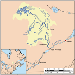
Watershed of Saint-Maurice River
|
|
| Location | La Tuque |
| Coordinates | 48°20′06″N 74°14′55″W / 48.33500°N 74.24861°W |
| Type | Natural |
| Primary inflows | Jean-Pierre River (Gouin Reservoir), Gouin Reservoir |
| Primary outflows | Gouin Reservoir |
| Basin countries | Canada |
| Max. length | 13.9 kilometres (8.6 mi) |
| Max. width | 2.5 kilometres (1.6 mi) |
| Surface elevation | 402 metres (1,319 ft) |
The Jean-Pierre Bay is a freshwater bay located in the south-eastern part of the large Gouin Reservoir. It's found in the town of La Tuque, within the Mauricie region of Quebec, Canada.
This bay was created in 1948 when the Gouin Dam was built. The dam raised the water levels, forming the bay from the Jean-Pierre River (Gouin Reservoir). Since then, Jean-Pierre Bay has been connected to Brochu Lake and is part of the huge Gouin Reservoir.
People mostly visit this area for fun activities like fishing, boating, and enjoying nature. Logging, which is cutting down trees for wood, is another important activity here. There's even a special airport for seaplanes (planes that land on water) near the Gouin Dam.
A road called Route 400 helps people get to the southern part of Jean-Pierre Bay. This road connects the Gouin Dam to the village of Parent, Quebec. There are also smaller forest roads used by loggers and tourists.
The surface of Jean-Pierre Bay usually freezes over from mid-November until the end of April. However, it's generally safe to walk or travel on the ice from early December to the end of March.
Contents
Geography of Jean-Pierre Bay
Jean-Pierre Bay is shaped like a long carrot, stretching for 13.9 kilometres (8.6 mi) from north to south. The Jean-Pierre River (Gouin Reservoir) flows into the east side of the bay. On its western side, the bay is surrounded by a series of mountains.
Where is Jean-Pierre Bay located?
Jean-Pierre Bay is part of the Gouin Reservoir, which was formed by the Gouin Dam. The spot where Jean-Pierre Bay meets Kikendatch Bay is:
- About 68.5 kilometres (42.6 mi) south-east of Obedjiwan, a village on the north shore of the Gouin Reservoir.
- About 52.5 kilometres (32.6 mi) north-west of Wemotaci, a village on the north shore of the Saint-Maurice River.
- About 143.8 kilometres (89.4 mi) north-west of downtown La Tuque.
- About 246.6 kilometres (153.2 mi) north-west of where the Saint-Maurice River flows into the St. Lawrence River in Trois-Rivières.
Rivers and Lakes Near Jean-Pierre Bay
Many rivers and lakes are connected to Jean-Pierre Bay. Here are some of the nearby water bodies:
- To the north: Gouin Reservoir, Kikendatch Bay, Brochu Lake, and Mink River.
- To the east: Kikendatch Bay, Saint-Maurice River, and Cypress River (La Tuque).
- To the south: Jean-Pierre River (Gouin Reservoir), Peter Lake, Ellwood Lake, and Huot River.
- To the west: Bouzanquet Bay, Five Mile Lake, Gouin Reservoir, De La Galette River (Gouin Reservoir), and Leblanc River (Gouin Reservoir).
Water from Brochu Lake flows into the northern part of Jean-Pierre Bay. The current from the Jean-Pierre River (Gouin Reservoir) flows through the northern part of Jean-Pierre Bay for about 7.5 kilometres (4.7 mi) until it reaches Kikendatch Bay. From there, the water flows eastward for about 12.0 kilometres (7.5 mi) to the Gouin Dam. After the dam, the water continues its journey down the Saint-Maurice River all the way to Trois-Rivières.
Naming of Jean-Pierre Bay
The name "Baie Jean-Pierre" is a French name. It was officially recognized on August 2, 1991, by the Commission de toponymie du Québec, which is the organization responsible for naming places in Quebec.
 | Lonnie Johnson |
 | Granville Woods |
 | Lewis Howard Latimer |
 | James West |


