Brochu Lake facts for kids
Quick facts for kids Brochu Lake |
|
|---|---|

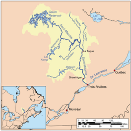
Watershed of Saint-Maurice River
|
|
| Location | La Tuque |
| Coordinates | 48°29′56″N 74°27′40″W / 48.49889°N 74.46111°W |
| Type | Natural |
| Primary inflows |
|
| Primary outflows | Kikendatch Bay (current going to Gouin Dam) |
| Basin countries | Canada |
| Max. length | 39.7 kilometres (24.7 mi) |
| Max. width | 14.4 kilometres (8.9 mi) |
| Surface elevation | 402 metres (1,319 ft) |
Brochu Lake is a large freshwater lake. It is located in the southeastern part of the Gouin Reservoir. This area is within the town of La Tuque, in the Mauricie region of Quebec, Canada.
The lake spreads across several areas called townships. Its current shape was formed in 1948. This happened when the Gouin Dam was built. The dam raised the water level of the Gouin Reservoir.
Most people visit Brochu Lake for fun outdoor activities. These include things like fishing and boating. Logging, which is cutting down trees, is also an important activity here.
Route 400 helps people get around the lake. This road connects the Gouin Dam to the village of Parent, Quebec. It runs along the southern part of Brochu Lake. It also serves a long piece of land that goes north into the Gouin Reservoir. This land is about 30.1 kilometres (18.7 mi) long. Other smaller roads are used for logging and tourism.
Brochu Lake usually freezes over in mid-November. The ice stays until the end of April. However, it's generally safe to be on the ice from early December to late March.
About Brochu Lake's Location
Brochu Lake gets its water from several rivers and lakes. In the north, it's fed by Magnan Lake and Nevers Lake. Lake Déziel also flows into it from the east. The Wapous River feeds Lake Déziel. The De La Galette River also flows into Brochu Lake. This happens through Bouzanquet Bay. From the southeast, the Atimokateiw River and Vison River add water.
There are groups of islands in the lake. Some islands separate Brochu Lake from Magnan Lake in the north. Other islands separate it from Nevers Lake in the west. Rocket Bay is found among these western islands.
The lake looks a bit like a palm tree. Its main part is about 39.7 kilometres (24.7 mi) long. It also has an arm that stretches southeast for 21 kilometres (13 mi). This arm reaches the Jean-Pierre Bay.
The water level of Brochu Lake depends on the Gouin Dam. The dam was built in 1948. The point where the southeast arm of Brochu Lake meets Jean-Pierre Bay is:
- About 59.5 kilometres (37.0 mi) southeast of Obedjiwan village. Obedjiwan is on a piece of land on the north shore of Gouin Reservoir.
- About 15.8 kilometres (9.8 mi) southwest of the Gouin Dam.
- About 62.8 kilometres (39.0 mi) northwest of Wemotaci village. Wemotaci is on the north shore of the Saint-Maurice River.
- About 152 kilometres (94 mi) northwest of downtown La Tuque.
- About 259 kilometres (161 mi) northwest of where the Saint-Maurice River ends. This is where it meets the St. Lawrence River at Trois-Rivières.
Rivers and Bays Around Brochu Lake
Many rivers and bays are connected to Brochu Lake.
- To the north: Magnan Lake (Gouin Reservoir), McSweeney Lake, Pokotciminikew River, Wapous River.
- To the east: Kikendatch Bay, Wapous River, Au Vison River, Au Vison River West.
- To the south: Jean-Pierre River, Leblanc River, Atimokateiw River, Jean-Pierre Bay.
- To the west: Bouzanquet Bay, Nevers Lake (Gouin Reservoir), Marmette Bay South, Kettle Bay, De La Galette River, Leblanc River.
The main bays of Brochu Lake are: Jean-Pierre Bay, Lion d'Or Bay, Wacipemakak Bay, Brochets Bay, Julien Bay, and Kikendatch Bay.
The main islands are: Women's Island, Cross Island, Kaminictikotanak Island, and Trembles Island.
Water flows from the northwest of the Gouin Reservoir through Brochu Lake. It moves southeast towards Jean-Pierre Bay. The current then crosses the northern part of this bay. It then enters Kikendatch Bay. From there, the water flows eastward for about 12.0 kilometres (7.5 mi) to the Gouin Dam. After the dam, the water flows down the Saint-Maurice River to Trois-Rivières.
Why is it Called Brochu Lake?
The name "Brochu Lake" was officially given in 1935. It honors Michel-Delphis Brochu. He was born in 1853 and passed away in 1933. Brochu was a doctor and a professor at Laval University.
He was known for his work with mental health. In the early 1900s, he was the general director of a hospital called Beauport asylum. This hospital is now known as the Institut universitaire en santé mentale de Québec.
Michel-Delphis Brochu also helped organize the First Congress of French-Speaking Doctors in America. This event took place in Quebec City in 1902. He was also the first president of the Association of French-Speaking Doctors of North America.
The name "Lac Brochu" was officially confirmed on December 18, 1986. This was done by the Commission de toponymie du Québec.
 | Precious Adams |
 | Lauren Anderson |
 | Janet Collins |


