Jean-Pierre River facts for kids
Quick facts for kids Jean-Pierre |
|
|---|---|

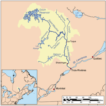
Map of Saint-Maurice watershed.
|
|

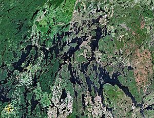
Map of Gouin Reservoir seen from space
|
|
| Country | Canada |
| Province | Quebec |
| Region | Mauricie |
| Physical characteristics | |
| Main source | Machinila Lake La Tuque, Mauricie, Quebec 500 m (1,600 ft) 48°09′41″N 74°10′20″W / 48.16139°N 74.17222°W |
| River mouth | Gouin Reservoir La Tuque, Mauricie, Quebec 402 m (1,319 ft) 48°17′47″N 74°13′50″W / 48.29639°N 74.23056°W |
| Length | 23.4 km (14.5 mi) |
| Basin features | |
| Tributaries |
|
The Jean-Pierre River is a river in Quebec, Canada. It flows into the Jean-Pierre Bay, which is part of the large Gouin Reservoir. This river is located in the area of La Tuque, within the Mauricie region.
The Jean-Pierre River flows through different areas called townships: Dansereau, Bureau, and Leblanc. It's found south of the Gouin Reservoir and west of the upper Saint-Maurice River. The main activity in this river valley is forestry, which means cutting down trees for wood. Tourism is also important, with people visiting for fun activities.
A road called Route 405 helps people get around this area. It connects the Gouin Dam to the village of Wemotaci, Quebec. This road runs along the west side of the Saint-Maurice River and serves the Jean-Pierre River Valley. There are also smaller forest roads used for logging and outdoor fun.
The river's surface usually freezes over from mid-November until the end of April. However, it's generally safe to walk or travel on the ice from early December to late March.
Where the River Flows
The Jean-Pierre River is part of a bigger network of waterways. Here are some of the rivers and lakes near it:
- North side: Gouin Reservoir, Kikendatch Bay, Au Vison River, Brochu Lake, Wapous River.
- East side: Kikendatch Bay, Saint-Maurice River, Cypress River.
- South side: Norah Creek, Najoua Creek, Saint-Maurice River, Huot River, Manouane River (La Tuque).
- West side: Leblanc River, Five Mile Lake, Kettle Bay, Chapman Lake (Gouin Reservoir), Gouin Reservoir.
River's Beginning
The Jean-Pierre River starts at a small lake called Machinila Lake. This lake is about 0.5 kilometers long and sits at an elevation of 500 meters.
The start of the river is located:
- About 4.2 kilometers southeast from where the Jean-Pierre River meets the Gouin Reservoir.
- About 22 kilometers south of the dam at the Gouin Reservoir.
- About 40.9 kilometers northeast of the village of Wemotaci, Quebec, which is along the Saint-Maurice River.
- About 132 kilometers northwest of downtown La Tuque.
River's Journey
From Machinila Lake, the Jean-Pierre River flows for about 23.4 kilometers. Here's how its journey unfolds:
- For 5.1 kilometers, it flows northeast, then north, crossing all of Lac Jean-Pierre.
- Next, it flows 3.3 kilometers north through Lake Sylvain and then part of Minister's Lake.
- It then travels 4.0 kilometers northwest to Lake Peter.
- After that, it goes 3.2 kilometers northeast, winding between mountains, until it reaches the outlet of South Lake.
- The river then flows 7.4 kilometers southwest, passing between two mountains and crossing a forest road. It also widens into a lake before reaching the eastern edge of the Leblanc township.
- Finally, it flows 0.4 kilometers northwest within the Leblanc township until it reaches its end.
River's End
The Jean-Pierre River joins the Gouin Reservoir in a place called Jean-Pierre Bay. This meeting point is:
- About 11.7 kilometers southwest of the Gouin Dam.
- About 66.4 kilometers southeast of the village of Obedjiwan, Quebec.
- About 56.0 kilometers northwest of the village of Wemotaci, Quebec.
- About 144.7 kilometers northwest of downtown La Tuque.
- About 251 kilometers northwest of where the Saint-Maurice River meets the St. Lawrence River in Trois-Rivières.
After joining Jean-Pierre Bay, the water flows north for 7.4 kilometers through the bay. Then, it flows east for 12.0 kilometers across Kikendatch Bay to the Gouin Dam. From there, the water continues along the Saint-Maurice River all the way to Trois-Rivières, where it finally flows into the St. Lawrence River.
River's Name
The name "Jean-Pierre" is a common French first name. The official name "Rivière Jean-Pierre" was made official on December 5, 1968, by the Commission de toponymie du Québec, which is the organization in Quebec responsible for naming places.
 | Misty Copeland |
 | Raven Wilkinson |
 | Debra Austin |
 | Aesha Ash |

