
Gouin Reservoir facts for kids
Quick facts for kids Gouin Reservoir |
|
|---|---|

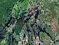
Gouin Reservoir seen from space.
|
|
| Lua error in Module:Location_map at line 416: Malformed coordinates value. | |
| Location | La Tuque, Mauricie, Quebec |
| Coordinates | Lua error in Module:Coordinates at line 614: attempt to index field 'wikibase' (a nil value). |
| Type | Artificial |
| Primary outflows | Saint-Maurice River |
| Basin countries | Canada |
| Max. length | 100 km (62 mi) |
| Max. width | 48 km (30 mi) |
| Surface area | 1,570 km2 (610 sq mi) |
| Average depth | 5 m (16 ft) |
| Shore length1 | 5,650 km (3,510 mi) |
| Surface elevation | 404 m (1,325 ft) |
| Islands | De l'Oasis Island |
| 1 Shore length is not a well-defined measure. | |
The Gouin Reservoir (in French: Réservoir Gouin) is a huge man-made lake in the middle of Quebec, Canada. It's not just one big lake, but a collection of many connected lakes. These lakes are separated by lots of peninsulas and islands. This makes its shoreline very long, over 5,600 km (3,500 mi)! The reservoir is the starting point of the Saint-Maurice River.
Contents
Fun Activities at Gouin Reservoir
This reservoir is a super popular spot for fishing. It has over 275 km (171 mi) of waterways. Many businesses offer fishing trips and places to stay right on the water. You can also go hunting, explore on snowmobiles or ATVs, or take boat trips. Some places even offer cabins or houseboats for you to stay in.
History of the Reservoir
The Gouin Reservoir is named after Lomer Gouin. He was the leader of Quebec (called the Premier of Quebec) when the reservoir was created in 1918. A company called Shawinigan Water & Power Company built a dam to create this reservoir. They did this to make electricity from the flowing water.
The reservoir helps control the water flow of the Saint-Maurice River. This is important for other power stations further downstream. At first, the main goal was to help float logs down the river to paper factories. The first dam was built in 1916-1917. Later, in 1948, the reservoir was made even bigger. They even changed the direction of some rivers, like the Mégiscane River and Suzie River. These rivers used to flow towards James Bay. But now, their water is sent to the Gouin Reservoir and then into the Saint Lawrence River through the Saint-Maurice River.
Obedjiwan Village
The small Atikamekw community of Obedjiwan is located on the north side of the reservoir. When the reservoir was first filled, the original village was flooded. So, the people moved and built their new village where Obedjiwan is today.
Oskélanéo Village
The village of Oskélanéo is connected to the Gouin Reservoir by Oskélanéo Lake and the Oskélanéo River. This river flows into Bureau Lake, which is part of the reservoir. Oskélanéo became a village around 1910 when a railroad was built there. It became a key spot for getting supplies and a starting point for hunting, fishing, and forestry projects in the northern part of Quebec.
How to Get to Gouin Reservoir
There aren't any paved roads directly to the Gouin Reservoir. But you can reach it by driving on forest roads, using snowmobile trails, or even by flying in.
- North side: You can use route 212 from Obedjiwan.
- East side: Forest road 451 connects the Gouin Dam to Wemotaci and La Tuque.
- South side: Forest road 400 goes to the south-east part, and road 404 connects Clova, Quebec and Parent.
- West side: Forest road R1009 runs along the west side of the reservoir.
Access by Waterway from the Railway
If you love outdoor adventures, you can reach the Gouin Reservoir by canoe from the Canadian National Railway line. This railway runs south of the reservoir.
- West part: You can canoe down rivers like the Kekek River, Suzie River, Mégiscane River, and Flapjack River.
- Center part: The Oskélanéo River is a popular route to reach the south part of Bureau Lake.
The villages of Parent and Clova, Quebec are about 40 km (25 mi) south of the reservoir. You can get there by forest road or by train. There's also a seaplane base right at the top of the Gouin dam.
Wildlife at Gouin Reservoir

The Gouin Reservoir area is home to many different animals.
Fish Species
The main fish you'll find here are walleye, northern pike, and sauger. Sometimes, people also catch lake trout and brook trout. Pike are very common because they love to eat smaller fish, and there are plenty of those here!
Waterfowl
You can spot many types of water birds in the region. These include the American black duck, mallard, green-winged teal, ring-necked duck, and different kinds of mergansers. You might also see common goldeneyes, buffleheads, common loons, Canada gooses, and even bald eagles.
Mammals
The forests around the reservoir are home to many mammals. You might see moose, white-tailed deer, bears, hares, red foxes, muskrats, skunks, and raccoons.
Remember, if you go fishing or hunting, there are rules about how many animals you can catch or hunt. These rules help protect the wildlife.
Gouin Reservoir Community Wildlife Area
There's a special group called the "Gouin Reservoir Community Wildlife Area." They work hard to protect the many different animals living here. They also help make sure fishing stays good for everyone. This group works with the government to manage the fish and wildlife resources.
Images for kids
-
Gouin Reservoir seen from space.
-
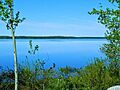
Gouin Reservoir at Obedjiwan
See also
 In Spanish: Embalse Gouin para niños
