Oskélanéo Lake facts for kids
Quick facts for kids Oskélanéo Lake |
|
|---|---|

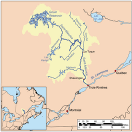
Watershed of Saint-Maurice River
|
|
| Location | La Tuque |
| Coordinates | 48°07′49″N 75°10′53″W / 48.13028°N 75.18139°W |
| Type | Lake of dam |
| Primary inflows |
|
| Primary outflows | Oskélanéo River (tributary of Bureau Lake (Gouin Reservoir) |
| Basin countries | Canada |
| Max. length | 15.8 kilometres (9.8 mi) |
| Max. width | 2.9 kilometres (1.8 mi) |
| Surface elevation | 404 metres (1,325 ft) |
Oskélanéo Lake is a freshwater lake in the province of Quebec, Canada. It is connected to the southwestern part of the Gouin Reservoir through Bureau Lake (Gouin Reservoir). The lake is located in the town of La Tuque, in the Mauricie region.
The lake is entirely within an area called Faucher. After the Gouin Dam was finished in 1948, it became easier for boats to travel between Oskélanéo Lake and the Gouin Reservoir. This is because there is only a small difference in water level between them.
Most people visit Oskélanéo Lake for fun activities like fishing and boating. Logging, which is cutting down trees for wood, is also an important activity in the area.
A railway line, part of the Canadian National Railway, crosses the middle of Oskélanéo Lake. It goes right through the village of Oskélanéo, which is on the west side of the lake.
Road 404 serves the area around the Oskélanéo River. It connects to Road 400, which links the Gouin Dam to the village of Parent, Quebec. These roads help people get to the lake for forestry and tourism.
The surface of Oskélanéo Lake is usually frozen from mid-November until the end of April. However, it's generally safe to walk or drive on the ice from early December to late March.
Contents
Exploring Oskélanéo Lake's Location
Oskélanéo Lake is surrounded by other important waterways. Knowing these helps us understand where the lake fits into the larger water system.
Rivers and Bays Around the Lake
- To the north, you'll find the Oskélanéo River and Bureau Lake (Gouin Reservoir).
- To the east are the Nemio River, Bouzanquet Bay, and the De La Galette River (Gouin Reservoir).
- To the south, there are the Gosselin River, Douville River, and Bazin River.
- To the west, you'll see Saraana Bay, the Mégiscane River, and Tessier Lake (Gouin Reservoir).
How the Lake is Fed
Oskélanéo Lake gets its water mainly from Parker Creek and Froissart Creek. It also receives water from Hill Lake, which flows into Haylow Bay, and from Marcotte and Bisborne Lakes to the south.
Haylow Bay extends about 2.1 kilometres (1.3 mi) westward near the lake's exit point. The lake is also divided into two parts by a narrow stretch of water, about 5.2 kilometres (3.2 mi) long. This narrow part is north of the railway bridge near Oskélanéo village.
Distances from the Lake's Exit
The exit point of Oskélanéo Lake is located:
- About 8.3 kilometres (5.2 mi) north of the village of Oskélanéo, Quebec.
- About 41.4 kilometres (25.7 mi) south of the exit of Bureau Lake (Gouin Reservoir).
- About 56.7 kilometres (35.2 mi) south of the village of Obedjiwan, Quebec, which is on the north shore of the Gouin Reservoir.
- About 80.5 kilometres (50.0 mi) southwest of the Gouin Dam.
- About 195.7 kilometres (121.6 mi) west of downtown La Tuque.
The Journey of the Water
From the exit of Oskélanéo Lake, the water travels a long way to the Gouin Dam, covering about 149.2 kilometres (92.7 mi). Here's how the water flows:
- It flows 12.6 kilometres (7.8 mi) north to the mouth of the Oskélanéo River.
- Then, it travels 43.8 kilometres (27.2 mi) north, crossing Bureau Lake (Gouin Reservoir).
- Finally, it goes 92.8 kilometres (57.7 mi) northeast across Marmette Lake, then southeast to the Gouin Dam.
From the Gouin Dam, the water continues its journey along the Saint-Maurice River all the way to Trois-Rivières.
The Name "Oskélanéo"
The name "Lac Oskélanéo" was officially recognized on December 5, 1968. This happened when the Commission de toponymie du Québec (Quebec's Place Names Commission) was created.
 | Claudette Colvin |
 | Myrlie Evers-Williams |
 | Alberta Odell Jones |


