Bureau Lake facts for kids
Quick facts for kids Bureau Lake |
|
|---|---|

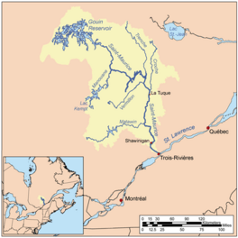
Watershed of Saint-Maurice River
|
|
| Location | La Tuque |
| Coordinates | 48°24′16″N 74°03′03″W / 48.40444°N 74.05083°W |
| Type | Lake of dam |
| Primary inflows |
|
| Primary outflows | Marmette Lake (Gouin Reservoir) |
| Basin countries | Canada |
| Max. length | 43.8 kilometres (27.2 mi) |
| Max. width | 16.8 kilometres (10.4 mi) |
| Surface elevation | 402 metres (1,319 ft) |
Lac Bureau is a large freshwater lake in Quebec, Canada. It's part of the huge Gouin Reservoir, located near the town of La Tuque in the Mauricie region.
The lake's shape changed a lot in 1948. That's when the Gouin Dam was built. This dam raised the water level, making Lac Bureau much bigger and connecting it to other lakes. The water level in the lake can change a lot, depending on how the dam is managed.
People mostly visit the area for fun activities like fishing and boating. Logging (cutting down trees) is another important activity here.
A road called Route 404 helps people get to the Oskélanéo River Valley and the south part of Lac Bureau. Other forest roads also lead to the lake.
The surface of Lac Bureau is usually frozen from mid-November to the end of April. However, it's generally safe to walk or drive on the ice from early December to the end of March.
What Makes Lac Bureau Special?
Lac Bureau is mainly fed by two rivers: the Nemio River from the east and the Oskélanéo River from the south. The lake is quite long, about 43.8 kilometres (27.2 mi) (27 miles).
It has a long peninsula that stretches 8.2 kilometres (5.1 mi) (5 miles) north from its southern shore. Next to this peninsula is a large island, almost as long. A small passage, about 0.6 kilometres (0.37 mi) (0.4 miles) wide, separates the island from the peninsula.
The lake has a few distinct parts:
- A southern bay that reaches into the Achintre and Sulte areas. This part of the lake receives water from the Oskélanéo River.
- An eastern bay that extends towards the Nemio River.
- A northern bay that also collects water from the Nemio River.
The water from Lac Bureau flows out on its northeast side. It goes through many islands into Marmette Lake. This exit point is just south of the village of Obedjiwan, Quebec.
How Water Flows from Lac Bureau
From where Lac Bureau connects to Marmette Lake, the water travels about 98 kilometres (61 mi) (61 miles) to the Gouin Dam.
The water flows in several stages:
- First, it goes east, winding around many islands and passing through Marmette Lake and then McSweeney Lake.
- Next, it moves southeast, crossing the Marmette Bay South and Nevers Lake. It also goes around islands like "Island of the Cross" and "Island of Women."
- Then, it heads east, going around a large piece of land on the south side of the Gouin Reservoir. After that, it turns into the southeast arm of Brochu Lake.
- Finally, it continues east to Kikendatch Bay until it reaches the Gouin Dam.
From the Gouin Dam, the water flows into the Saint-Maurice River all the way to Trois-Rivières.
Why is it Called Lac Bureau?
The name "Lac Bureau" honors Joseph Bureau (1837-1914). He was an explorer and mapmaker born near Quebec City. He traveled all over Quebec, from Labrador to Outaouais and from the Saint Lawrence River to Hudson Bay, helping to map the land.
In 1870, he helped find the best route for a railway to Lac Saint-Jean and Mauricie. The next year, he explored the Saint-Maurice River all the way to its source.
Joseph Bureau stayed active throughout his life. The lake is also known by the Attikamek name "Opiskaw Sakahikan," which means "High Lake."
The name "Lac Bureau" was officially recognized on December 18, 1986, by the Quebec Place Names Commission.
 | Ernest Everett Just |
 | Mary Jackson |
 | Emmett Chappelle |
 | Marie Maynard Daly |


