Chapman Lake (Gouin Reservoir) facts for kids
Quick facts for kids Chapman Lake |
|
|---|---|

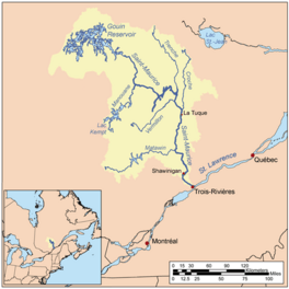
Watershed of Saint-Maurice River
|
|
| Location | La Tuque |
| Coordinates | 48°24′01″N 74°40′39″W / 48.40028°N 74.67750°W |
| Type | Lake of dam |
| Primary inflows |
|
| Primary outflows | Nevers Lake (Gouin Reservoir) |
| Basin countries | Canada |
| Max. length | 13.4 kilometres (8.3 mi) |
| Max. width | 3.1 kilometres (1.9 mi) |
| Surface elevation | 402 metres (1,319 ft) |
Chapman Lake is a large freshwater lake. You can find it in the middle of the Gouin Reservoir. This area is part of the town of La Tuque in Quebec, Canada. It's a big part of the Mauricie region.
The lake spreads across three areas called cantons: Chapman, Huguenin, and Nevers. The lake's current shape was created after the Gouin Dam was finished in 1948. This dam raised the water level of the Gouin Reservoir. The water level in Chapman Lake changes a lot because it depends on the dam.
Most of the money made in this area comes from tourism and recreation. This means activities like fishing, boating, and enjoying nature. Forestry, which is about cutting down trees, is the second most important activity.
A road connects to Quebec route 400 in the south. This road helps people get to the southern part of Chapman Lake. Route 400 also goes near the Jean-Pierre River and Leblanc River. It serves a long piece of land that sticks out into the Gouin Reservoir. Other smaller forest roads are used for logging and for people visiting the area.
Chapman Lake usually freezes over from mid-November to the end of April. But it's generally safe to walk or drive on the ice from early December to the end of March.
Exploring Chapman Lake's Geography
Chapman Lake gets its water from several places. These include the water flowing out of Kaminitikwakamak Lake. It also gets water from Lac Déboisé and Kaacikitaporonaniwok Lake. Another source is a narrow passage connecting it to Marmette Bay South.
This lake is about 13.4 kilometres (8.3 mi) long. Its southern part stretches for about 3.4 kilometres (2.1 mi). This southern section is separated by a piece of land that is 1.6 kilometres (0.99 mi) long. On the west side of the lake, there is a bay that goes 2.1 kilometres (1.3 mi) into the land.
Many islands are lined up from north to south in the northern part of Chapman Lake. These islands are between Marmette Bay South to the west and Nevers Lake to the east. The longest of these islands is 21.4 kilometres (13.3 mi) long.
One island, about 2.7 kilometres (1.7 mi) long, crosses the northern edge of the lake. A 4.5 kilometres (2.8 mi) narrow passage goes west of this island. This passage connects to Marmette Bay South. Another passage, 3.5 kilometres (2.2 mi) long, separates the east side of this island from a piece of land connected to the south shore of the Gouin Reservoir.
The water level of Chapman Lake depends on the Gouin Dam. This dam was built in 1948. The place where Chapman Lake meets Nevers Lake is important. It is located:
- About 31.1 kilometres (19.3 mi) southeast of Obedjiwan, Quebec. Obedjiwan is a village on a piece of land in the northern Gouin Reservoir.
- About 42.5 kilometres (26.4 mi) west of the Gouin Dam.
- About 89.1 kilometres (55.4 mi) northwest of Wemotaci, Quebec. This village is on the north shore of the Saint-Maurice River.
- About 178 kilometres (111 mi) northwest of downtown La Tuque.
- About 283 kilometres (176 mi) northwest of where the Saint-Maurice River flows into the Saint Lawrence River at Trois-Rivières.
Rivers and Lakes Around Chapman Lake
The areas that drain water into Chapman Lake are:
- To the north: Nevers Lake, Marmette Bay South, Marmette Lake, and McSweeney Lake.
- To the east: Nevers Lake, Five Mile Lake, Jean-Pierre Bay (Gouin Reservoir), Atimokateiw River, Kikendatch Bay, and the Saint-Maurice River.
- To the south: Lac Garancières, Lac Francoeur, Lac Delâge, Decelles Lake, Bazin River, and De La Galette River (Gouin Reservoir).
- To the west: Lake Lepage, Nemio River, and Bureau Lake.
From where Chapman Lake meets Nevers Lake, the water flows for about 51 kilometres (32 mi) to the Gouin Dam. It flows in these steps:
- First, it goes east, around "Island of the Cross," "Island of Women," and Kaminictikotanak Island.
- Then, it goes east again, around a large piece of land connected to the southern shore of the Gouin Reservoir. After that, it turns into the southeast arm of Brochu Lake.
- Finally, it flows east through Kikendatch Bay until it reaches the Gouin Dam.
From the Gouin Dam, the water continues to flow along the Saint-Maurice River all the way to Trois-Rivières.
What's in a Name?
The name "Chapman" is a family name that comes from England.
The name "lac Chapman" was officially recognized on December 18, 1986. This was done by the Commission de toponymie du Québec, which is the organization in Quebec that names places.
 | Chris Smalls |
 | Fred Hampton |
 | Ralph Abernathy |


