Bouzanquet Bay facts for kids
Quick facts for kids Bouzanquet Lake |
|
|---|---|

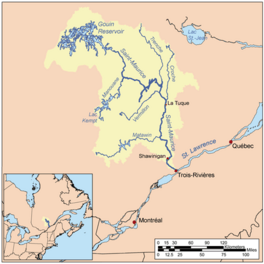
Watershed of Saint-Maurice River
|
|
| Location | La Tuque |
| Coordinates | 48°20′46″N 74°28′28″W / 48.34611°N 74.47444°W |
| Type | Natural |
| Primary inflows |
|
| Primary outflows | Brochu Lake (Gouin Reservoir) |
| Basin countries | Canada |
| Max. length | 15.8 kilometres (9.8 mi) |
| Max. width | 3.8 kilometres (2.4 mi) |
| Surface elevation | 402 metres (1,319 ft) |
Bouzanquet Bay is a large freshwater bay. It is part of the Gouin Reservoir in Quebec, Canada. This bay is located in the town of La Tuque, in the Mauricie region.
The bay stretches across different areas called cantons: Nevers, Delage, and Leblanc. Its current shape was formed in 1948. This happened when the Gouin Dam was built, raising the water levels of the Gouin Reservoir.
People mostly visit this area for fun activities like tourism. Forestry, which is cutting down trees, is also an important activity here.
A road called Route 400 helps people get around. It connects the Gouin Dam to the village of Parent, Quebec. This road goes along the southern part of Bouzanquet Bay. It also serves the areas around the Jean-Pierre River and Leblanc River. Other smaller forest roads are used for logging and outdoor fun.
The surface of Bouzanquet Bay usually freezes from mid-November. It stays frozen until the end of April. However, it's generally safe to walk or drive on the ice from early December to late March.
Contents
About Bouzanquet Bay
Bouzanquet Bay gets its water from several rivers and lakes. These include the Leblanc River, the De La Galette River, Lake Delâge, and Lac des Cinq Milles.
Size and Shape
The bay is about 15.8 kilometres (9.8 mi) long. It looks a bit like a banana that is open towards the west. The water from the De La Galette River flows for 7.8 kilometres (4.8 mi) northeast. Then, it continues for 8.0 kilometres (5.0 mi) northwest to where the bay opens up.
A narrow passage called "Bouzanquet Pass" is on the north side. It is 0.7 kilometres (0.43 mi) long. This pass connects Bouzanquet Bay to the southwest part of Brochu Lake.
Water Levels and Location
The water level in Bouzanquet Bay depends on the Gouin Dam. This dam was built in 1948. The spot where Bouzanquet Bay meets Brochu Lake is:
- 44.6 kilometres (27.7 mi) southeast of Obedjiwan, Quebec. Obedjiwan is a village on a peninsula in the Gouin Reservoir.
- 31.0 kilometres (19.3 mi) southwest of the Gouin Dam.
- 76.1 kilometres (47.3 mi) northwest of Wemotaci, Quebec. This village is on the north shore of the Saint-Maurice River.
- 165 kilometres (103 mi) northwest of downtown La Tuque.
- 270 kilometres (170 mi) northwest of where the Saint-Maurice River flows into the Saint Lawrence River at Trois-Rivières.
Surrounding Areas
The areas around Bouzanquet Bay that contribute water to it are:
- North: Brochu Lake, Nevers Lake, McSweeney Lake.
- East: Jean-Pierre River, Jean-Pierre Bay, Atimokateiw River, Kikendatch Bay, Saint-Maurice River.
- South: Leblanc River, Decelles Lake, Bazin River, De La Galette River.
- West: Five Mile Lake, Chapman Lake, Bureau Lake, Marmette Bay South.
The main islands in Bouzanquet Bay are Main Island and Boar Island.
From the "Bouzanquet Pass," the water flows through the Gouin Reservoir for 34.8 kilometres (21.6 mi). This path includes:
- Crossing the southwest part of Brochu Lake to the north.
- Going around a large piece of land to the north.
- Then, it turns east through Brochu Lake and finally southeast.
- It continues east to Kikendatch Bay and then to the Gouin Dam.
From the Gouin Dam, the water flows down the Saint-Maurice River all the way to Trois-Rivières.
Why the Name?
The name "Bouzanquet Bay" honors Gaston Bouzanquet. He was a respected officer and a member of the Society of Geography of Quebec. Bouzanquet wrote a text in 1928 about the history of New France. He focused on Monsieur de Montcalm, an important historical figure. Bouzanquet also attended the opening of the Montcalm monument in Quebec City in 1911.
The name "Baie Bouzanquet" became official on December 5, 1968. This was done by the Commission de toponymie du Quebec, which is the official body for naming places in Quebec.
 | Jewel Prestage |
 | Ella Baker |
 | Fannie Lou Hamer |


