De La Galette River facts for kids
Quick facts for kids De La Galette |
|
|---|---|

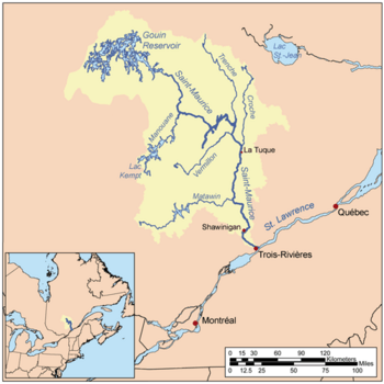
Map of Saint-Maurice watershed.
|
|

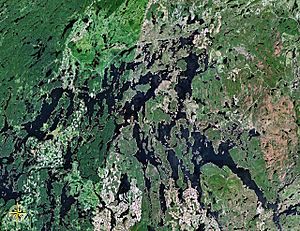
Map of Gouin Reservoir seen from space
|
|
| Country | Canada |
| Province | Quebec |
| Region | Mauricie |
| Physical characteristics | |
| Main source | Unidentified Lake La Tuque (canton de Fréchette), Mauricie, Quebec 449 m (1,473 ft) 48°09′51″N 74°31′05″W / 48.16417°N 74.51806°W |
| River mouth | Gouin Reservoir La Tuque, Mauricie, Quebec 402 m (1,319 ft) 48°18′58″N 74°28′00″W / 48.31611°N 74.46667°W |
| Length | 34.2 km (21.3 mi) |
| Basin features | |
| Tributaries |
|
The De La Galette River (which means "River of the Galette" in French) is a river in Quebec, Canada. It flows into the southern part of the Gouin Reservoir, specifically into Bouzanquet Bay. This river is located within the area of La Tuque, in the Mauricie region.
The De La Galette River flows through the Fréchette and Delâge townships. It is found south of the Gouin Reservoir and west of the upper Saint-Maurice River. The main activity in this river valley is forestry, which means cutting down trees for wood. After forestry, tourism and recreation are the next most important activities.
A road called Quebec route 400 helps people get around the De La Galette River valley. This road connects the Gouin Dam to the village of Parent, Quebec. It also serves a long piece of land that sticks out into the Gouin Reservoir. Other smaller forest roads are used for logging and for people enjoying outdoor activities. The river's surface is usually frozen from mid-November to the end of April. However, it's generally safe to walk or travel on the ice from early December to late March.
Contents
Where is the De La Galette River?
The De La Galette River starts from an unnamed lake. This lake is about 2.2 kilometers (1.4 miles) long and sits at an elevation of 449 meters (1,473 feet).
The river's starting point is:
- 7.2 km (4.5 mi) southeast of where the De La Galette River meets Delâge Lake.
- 17.2 km (10.7 mi) south of where the De La Galette River flows into Bouzanquet Bay of the Gouin Reservoir.
- 37.6 km (23.4 mi) southwest of the dam at the Gouin Reservoir's end.
- 62.7 km (39.0 mi) west of the village of Wemotaci, Quebec, which is along the Saint-Maurice River.
- 153.3 km (95.3 mi) northwest of downtown La Tuque.
How the River Flows
The De La Galette River flows for about 34.2 kilometers (21.3 miles). Here's how its journey goes:
- It flows southwest for 5.3 km (3.3 mi). During this part, it crosses another unnamed lake for 2.4 km (1.5 mi). This lake is 3.3 km (2.1 mi) long and 436 meters (1,430 feet) high.
- Then, it turns north for 6.6 km (4.1 mi), flowing past the west side of a mountain.
- Next, it flows north, then east, then north again for 6.5 km (4.0 mi) in Delâge Township. It reaches the southwest part of Lac Delâge.
- It crosses Lac Delâge for 8.0 km (5.0 mi). This lake is 8.1 km (5.0 mi) long and 402 meters (1,319 feet) high.
- Finally, it flows north for 7.8 km (4.8 mi) through De La Galette Lake (Gouin Reservoir). This lake is also 402 meters (1,319 feet) high.
Where the River Ends
The De La Galette River ends when it flows into the Gouin Reservoir. This meeting point is located:
- 27.8 km (17.3 mi) southwest of the Gouin Dam.
- 52.1 km (32.4 mi) southeast of the village of Obedjiwan, Quebec. This village is on a piece of land sticking out into the Gouin Reservoir.
- 68.7 km (42.7 mi) northwest of the village of Wemotaci, Quebec, which is on the north shore of the Saint-Maurice River.
- 160 km (99 mi) northwest of downtown La Tuque.
- 262.6 km (163.2 mi) northwest of where the Saint-Maurice River meets the Saint Lawrence River in Trois-Rivières.
From the mouth of De La Galette Lake, the water flows northwest for 9.5 km (5.9 mi) to the mouth of Bouzanquet Bay. Then, it crosses the Gouin Reservoir for 34.8 km (21.6 mi). It goes around a large piece of land to the north, crossing Brochu Lake and Kikendatch Bay until it reaches the Gouin Dam. From this dam, the water continues to flow along the Saint-Maurice River all the way to Trois-Rivières.
What's in the River's Area?
The areas around the De La Galette River include many other bodies of water:
- North side: Gouin Reservoir, Bouzanquet Bay, Five Mile Lake, Brochu Lake, Kettle Bay.
- East side: Atimokateiw River, Leblanc River (Gouin Reservoir), Jean-Pierre River, Saint-Maurice River, Cypress River (La Tuque), Najoua River.
- South side: Decelles Lake, Bazin River, Norah Creek, Bellerive River, West Pichoui River.
- West side: Francoeur Lake, Five Mile Lake, Gouin Reservoir (South Bay), Nemio River.
How Did the River Get Its Name?
The name "De La Galette River" likely came into use in the late 1800s. This was when logging became very popular in the Haute-Mauricie region.
In 1906, a team of surveyors explored the area up the Galette River. At that time, this river, which flowed into the Saint-Maurice River, was more than 55 kilometers (34 miles) long. However, when the Loutre Dam was built in 1918, the water levels in the Gouin Reservoir rose, making the river shorter. Then, the Gouin Dam was built in 1948, which made the river even shorter, to about 15 km (9.3 mi). The name "Galette" might come from a landform that looks like a flat slab or pancake.
In the past, in French Canada, a "galette" was a type of flat cookie or pancake. These "galettes" were often made from oats, wheat, corn, or buckwheat, mixed with things like molasses or maple syrup.
French Canadian names have used "Galette" for a long time. A document from 1673 mentions "La Galette rapids" and a trading post called "La Galette." Today, in Quebec, there are about a dozen places named "Galette," mostly lakes.
The name "De la Galette River" was officially recognized on December 5, 1968, by the Commission de toponymie du Québec (Quebec's Place Names Commission).
 | Aurelia Browder |
 | Nannie Helen Burroughs |
 | Michelle Alexander |

