Dead Camel Mountains facts for kids
Quick facts for kids Dead Camel Mountains |
|
|---|---|

Dead Camel Mountains
|
|
| Highest point | |
| Elevation | 1,464 m (4,803 ft) |
| Geography | |
| Country | United States |
| State | Nevada |
| District | Churchill County |
| Range coordinates | 39°18′37.709″N 118°57′5.558″W / 39.31047472°N 118.95154389°W |
| Topo map | USGS Salt Cave |
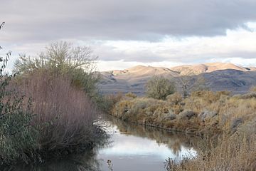
The Dead Camel Mountains are a mountain range located in western Nevada in the United States. They are not very tall, with their highest point reaching about 1,464 meters (4,803 feet). These mountains separate the Lahontan Reservoir from the city of Fallon, Nevada.
Contents
Exploring the Dead Camel Mountains
The Dead Camel Mountains might not be the tallest, but they hold some interesting secrets. They are a unique part of the landscape in Churchill County.
Where Are These Mountains?
You can find the Dead Camel Mountains in the western part of Nevada. They are a smaller mountain range. Their highest point is 1,464 meters (4,803 feet) above sea level. This makes them a noticeable feature in the local area.
Ancient Art and Rock Formations
On the eastern side of the Dead Camel Mountains, there are several small caves. One of these caves is very special. It contains many pictographs. These are ancient drawings or symbols made by people who lived there a very long time ago. They tell us about the early inhabitants of the area.
This region also has interesting tufa formations. Tufa is a type of limestone rock. It forms when minerals from water build up over time. These formations often look unique and can be found near springs or ancient lakebeds.
The Story of Lake Lahontan
The pictographs and tufa formations are connected to something called Lake Lahontan. This was a huge ancient lake that covered much of Nevada during the last Ice Age. It was much larger than any lake in the area today. The people who made the pictographs lived near the shores of this vast lake. The tufa formations also formed because of the minerals in the ancient lake's water. Studying these features helps scientists understand what the area was like thousands of years ago.
 | James Van Der Zee |
 | Alma Thomas |
 | Ellis Wilson |
 | Margaret Taylor-Burroughs |


