Deep Creek (Melbourne) facts for kids
Quick facts for kids Deep |
|
|---|---|

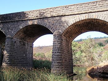
Bridge over the Deep Creek at Bulla, built in 1869.
|
|

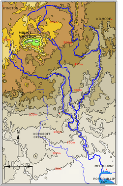
Contour map of the Maribyrnong River basin; Deep Creek is the eastern tributary that rises on the northern slopes of Mount Macedon.
|
|
| Country | Australia |
| State | Victoria |
| Region | Victorian Midlands (IBRA), Greater Melbourne |
| Local government area | Macedon Ranges Shire, Hume, Brimbank |
| Physical characteristics | |
| Main source | Macedon and Cowbaw ranges, Great Dividing Range near Cobaw 517 m (1,696 ft) 37°16′30″S 144°35′58″E / 37.27500°S 144.59944°E |
| River mouth | confluence with the Jackson Creek to form the Maribyrnong River west of Melbourne Airport 42 m (138 ft) 37°40′10″S 144°48′16″E / 37.66944°S 144.80444°E |
| Length | 128 km (80 mi) |
| Basin features | |
| River system | Port Phillip catchment |
| Tributaries |
|
The Deep Creek is a river in Victoria, Australia. It flows through the outer north-western parts of Melbourne. This river is part of the Port Phillip area, where many waterways collect before flowing into the bay.
Contents
Where Is Deep Creek Located?
Deep Creek starts high up in the Macedon Ranges and the Cobaw Range. These ranges are part of the larger Great Dividing Range. The creek begins north of Mount Macedon, near a place called Cobaw.
The river first flows east through a wide, flat valley. Then, it turns south towards Penmore. Here, the valley becomes much deeper and narrower. It flows east again for a bit, then heads south once more at Darraweit Guim. It continues south towards Bulla. Along its journey, many smaller streams join it.
The Deep Creek meets the Jackson Creek near Bulla. When these two creeks join, they form the Maribyrnong River. The deep valley carved by Deep Creek is very noticeable in areas like Darraweit Guim and Bulla. The creek drops about 475 metres (1,558 ft) over its 128-kilometre (80 mi) length.
Water Levels and Flow
Deep Creek does not have large dams or diversions controlling its water. This means the amount of water in the creek changes a lot with the seasons. In drier times, some parts of Deep Creek might only flow during certain months. However, many deep pools and stretches of water remain all year. Some of these spots are popular places for swimming.
What Does "Deep Creek" Mean?
The name "Deep Creek" might come from a few different things. One idea is that it refers to the deep valley the river has cut into the plains north of Melbourne. Another idea is that it's named after the deep pools found in the riverbed.
This creek was once thought to be part of the Maribyrnong River. Because of this, it was sometimes called the Saltwater River. This was an old name for the Maribyrnong River. Other names included Upper Maribyrnong River or Maribyrnong River East Branch. The town of Darraweit Guim, located on the river, was also a possible name for the creek.
What Are Deep Creek's Tributaries?
A tributary is a smaller stream or river that flows into a larger one. Deep Creek has several named tributaries that join it. These are listed here, starting from the one closest to where Deep Creek joins the Maribyrnong River and moving upstream:
- Jacksons Creek
- Emu Creek
- Konagaderra Creek
- Boyd Creek
- Five Mile Creek
- Long Gully Creek
- Dry Creek
- Monument Creek
- Garden Hut Creek
Bridges and Crossings Over Deep Creek
Many bridges and crossing points allow people to get over Deep Creek. Here are some of the important ones, listed from downstream (closer to the Maribyrnong River) to upstream (closer to the source):
- Bulla Bridge (This famous bluestone bridge was built in 1869. It replaced an older wooden bridge.)
- Wildwood Road
- Konagaderra Road
- McCabes Bridge (on Stockdale Road)
- Darraweit Valley Road
- Chintin Road
- Gallaghers Ford (on Joyces Road)
- Dalys Bridge (on Woodend – Wallan Road)
- Sheehans Crossing bridge (on Sheehans Road)
- Forbes Bridge (on Forbes Road)
- Doggetts Bridge (on Lancefield – Kilmore Road)
- Musteys Bridge (on Lancefield – Tooborac Road)
- Linehans Bridge (on Baynton Road) (The old bridge is now closed. A new low-level crossing was built in the 1990s.)
- Twin Bridges (on Kyneton – Lancefield Road)
- White Bridge (on Whitebridge Road)

