Deerfield, Missouri facts for kids
Quick facts for kids
Deerfield, Missouri
|
|
|---|---|
|
Village
|
|

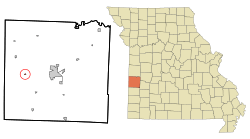
Location of Deerfield, Missouri
|
|
| Country | United States |
| State | Missouri |
| County | Vernon |
| Area | |
| • Total | 0.10 sq mi (0.26 km2) |
| • Land | 0.10 sq mi (0.26 km2) |
| • Water | 0.00 sq mi (0.00 km2) |
| Elevation | 787 ft (240 m) |
| Population
(2020)
|
|
| • Total | 40 |
| • Density | 392.16/sq mi (151.76/km2) |
| Time zone | UTC-6 (Central (CST)) |
| • Summer (DST) | UTC-5 (CDT) |
| ZIP code |
64741
|
| Area code(s) | 417 |
| FIPS code | 29-18802 |
| GNIS feature ID | 2398707 |
Deerfield is a small village located in Vernon County, Missouri, in the United States. In 2020, the village had a population of 40 people. It is a quiet place with a rich history.
Contents
Discovering Deerfield's Past
Deerfield was first settled a long time ago, in the 1830s. This was a time when many people were moving west to find new homes. The actual town area was officially planned out in 1871. It got its name from the Deerfield Township, which is the larger area it is part of. A post office has been open in Deerfield since 1856, helping people send and receive letters for many years.
Where is Deerfield Located?
Deerfield is found along US Route 54, which is a major road. It's about seven miles west of a larger town called Nevada. Two rivers flow near Deerfield. The Marmaton River runs along the north side of Route 54. Dry Wood Creek flows past the east side of the village and joins the Marmaton River about a mile northeast.
The village of Deerfield is quite small in size. According to official measurements, it covers an area of about 0.10 square miles (0.26 square kilometers). All of this area is land, meaning there are no large lakes or rivers within the village limits.
How Many People Live in Deerfield?
The number of people living in Deerfield has changed over the years. Here is a look at the population from different census counts:
| Historical population | |||
|---|---|---|---|
| Census | Pop. | %± | |
| 1890 | 239 | — | |
| 1900 | 222 | −7.1% | |
| 1910 | 129 | −41.9% | |
| 1920 | 238 | 84.5% | |
| 1930 | 165 | −30.7% | |
| 1940 | 187 | 13.3% | |
| 1950 | 138 | −26.2% | |
| 1960 | 122 | −11.6% | |
| 1970 | 112 | −8.2% | |
| 1980 | 95 | −15.2% | |
| 1990 | 85 | −10.5% | |
| 2000 | 75 | −11.8% | |
| 2010 | 81 | 8.0% | |
| 2020 | 40 | −50.6% | |
| U.S. Decennial Census | |||
Deerfield's Population in 2010
In 2010, the census counted 81 people living in Deerfield. These people lived in 33 different homes, and 24 of these were families. The village had about 810 people per square mile. There were 34 houses or places to live in total.
Most of the households in Deerfield were married couples living together. About one-third of the homes had children under 18 living there. The average number of people in each home was about 2.45.
The average age of people in Deerfield in 2010 was about 39.6 years old. About 23.5% of the residents were under 18. About 14.8% were 65 years old or older. Slightly more than half of the residents were male (53.1%), and the rest were female (46.9%).
See also
In Spanish: Deerfield (Misuri) para niños
 | Percy Lavon Julian |
 | Katherine Johnson |
 | George Washington Carver |
 | Annie Easley |

