Delbarton, West Virginia facts for kids
Quick facts for kids
Delbarton, West Virginia
|
||
|---|---|---|

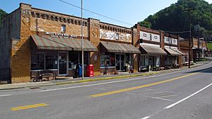
Rockhouse Drive in Delbarton
|
||
|
||

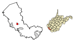
Location of Delbarton in Mingo County, West Virginia.
|
||
| Country | United States | |
| State | West Virginia | |
| County | Mingo | |
| Area | ||
| • Total | 1.99 sq mi (5.15 km2) | |
| • Land | 1.99 sq mi (5.15 km2) | |
| • Water | 0.00 sq mi (0.00 km2) | |
| Elevation | 764 ft (233 m) | |
| Population
(2010)
|
||
| • Total | 579 | |
| • Estimate
(2019)
|
497 | |
| • Density | 250.13/sq mi (96.57/km2) | |
| Time zone | UTC-5 (Eastern (EST)) | |
| • Summer (DST) | UTC-4 (EDT) | |
| ZIP code |
25670
|
|
| Area code(s) | 304 | |
| FIPS code | 54-20980 | |
| GNIS feature ID | 1538117 | |
| Website | Town of Delbarton | |
Delbarton is a small town located in Mingo County, West Virginia, in the United States. In 2020, about 522 people lived there.
Contents
History of Delbarton
Delbarton officially became a town on September 6, 1946. This happened when the Mingo County Circuit Court approved its incorporation.
How Delbarton Got Its Name
The name Delbarton comes from a large country estate in New Jersey. This estate belonged to Luther Kountze, a rich financier from Wall Street. He was also a part owner of a big coal mining company called United Thacker Land Company. Today, a Catholic high school, the Delbarton School, is on that same estate. Both the estate and the town of Delbarton got their name from combining parts of the names of Kountze's three children: DELancey, BARclay, and LivingsTON.
Delbarton's Coal Mining Past
Before it was an official town, Delbarton was a "coal camp." This means it was a community built and owned by the Thacker coal company. They needed places for their miners to live. In 1909, Luther Kountze bought thousands of acres of land in the area. He bought it from Jane Hatfield, a woman whose husband, Ellison Hatfield, had been killed in the famous Hatfield-McCoy Feud. Jane needed money for her family and sold the land cheaply. She didn't know how much valuable coal was hidden beneath it. After buying this land, Delbarton was created. It became a home for the miners who came to work in the new coal mines.
The town is in the middle of the richest coal area in West Virginia. This area is known as the Williamson Coalfield.
Changes in Delbarton's Economy
Like many towns in coal regions, Delbarton has faced economic challenges. Over the past few decades, the number of jobs in coal mining has dropped a lot. This is because less coal is being mined in the area. Also, new ways of mining coal need fewer workers. This has led to fewer jobs for the people of Delbarton.
However, the town is adapting. Some old buildings that were once used for shops or mining offices are now being used for tourism. This helps bring new visitors and money to the town.
Geography
Delbarton covers a total area of about 2.01 square miles (5.2 square kilometers). All of this area is land.
Population Information
| Historical population | |||
|---|---|---|---|
| Census | Pop. | %± | |
| 1950 | 1,353 | — | |
| 1960 | 1,122 | −17.1% | |
| 1970 | 903 | −19.5% | |
| 1980 | 981 | 8.6% | |
| 1990 | 705 | −28.1% | |
| 2000 | 474 | −32.8% | |
| 2010 | 579 | 22.2% | |
| 2020 | 522 | −9.8% | |
| U.S. Decennial Census | |||
Delbarton's Population in 2010
In 2010, the town of Delbarton had 579 people living there. There were 260 households and 150 families. The town had about 288 people per square mile.
Most of the people living in Delbarton were White (96.4%). A small number were African American (0.7%), Native American (0.2%), or Asian (0.2%). About 2.6% of the people were from two or more races.
The average age of people in Delbarton was 39.3 years old. About 22.1% of residents were under 18. About 11.6% were 65 years old or older. Slightly more than half of the residents (54.1%) were male, and 45.9% were female.
See also
 In Spanish: Delbarton (Virginia Occidental) para niños
 | James Van Der Zee |
 | Alma Thomas |
 | Ellis Wilson |
 | Margaret Taylor-Burroughs |


