
Derventio Brigantum facts for kids

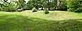
Visible remains at Orchard Field, Malton showing the surviving earthworks of the north east corner of the fort
|
|

Location in North Yorkshire
|
|
| Location | Malton, North Yorkshire |
|---|---|
| Region | Yorkshire |
| Coordinates | 54°08′10″N 0°47′25″W / 54.136190°N 0.79031020°W |
| Type | Roman fort |
| History | |
| Founded | AD 70 |
| Abandoned | 5th century |
| Site notes | |
| Archaeologists | Philip Corder, John Kirk, Leslie Peter Wenham |
| Public access | Partly in public parkland |
Derventio was a Roman fort and settlement in what is now North Yorkshire, England. It was built under the modern town of Malton. The fort was located about 18 miles north-east of Eboracum (modern-day York). It sat right by the River Derwent.
Derventio is sometimes called Derventio Brigantium. This Latin name means "Derventio of the Brigantes". It helped people tell it apart from other places named Derventio.
Contents
What's in a Roman Name?
The Roman name for the Malton fort first appeared in old Roman travel guides. These guides were called the Antonine Itinerary. This was around the late 100s AD.
Derventio was also mentioned in another old Roman document. This document was called the Notitia Dignitatum. It listed all the Roman army units and where they were stationed.
Digging Up the Past: Archaeology
Archaeologists have learned a lot about Derventio by digging there. The first big digs happened in the 1930s. Philip Corder and John Kirk led these early investigations.
The things they found helped start the Malton Museum. They dug up parts of the fort's walls and buildings. They also found signs of a civilian town outside the fort.
More digging took place from 1949 to 1952. The Ministry of Works found many layers of activity. They uncovered a Roman road and several buildings. They even found a beautiful mosaic floor.
In 1970, Leslie Peter Wenham found timber and stone buildings. These showed that the fort was rebuilt many times. This happened during different Roman emperors' reigns. They also found older fort defenses under the civilian town.

The Roman Fort at Derventio
The first fort at Malton was built around 70 AD. This was during the time of Agricola, a famous Roman general. It was built around the same time as the big fortress at Eboracum (York).
The first fort was made of wood. Later, in the early 100s AD, its walls were rebuilt with stone. The fort was big enough to house a cavalry unit. Cavalry units were soldiers who fought on horseback.
One specific cavalry unit was stationed here. It was called the Ala Gallorum Picentiana. This means "The Picentine wing of Gauls." We know this from an altar found in the ruins of a bathhouse.
Another unit, the "Numerus Syrorum Saggitariorum", may also have served here. These were archers from Syria.
Life Outside the Fort: Civilian Settlement
Like many Roman forts, a town grew up around Derventio. This civilian settlement was called a vicus. It was located outside the fort's main gates.
The town spread out from the south gate. It even crossed to the south side of the River Derwent. Many buildings were found here. One large building had heated floors.
Archaeologists found buildings that might have been workshops or store-houses. They found lots of pottery and coins in these areas. This shows the town was busy in the late 200s and early 300s AD.
People in the town likely used a nearby spring for water. This spring might have supplied a bath-house. However, the bath-house itself has not been found yet.
Trade and Economy in Roman Malton
Derventio was well-connected for trade. The fort was on the north bank of the River Derwent. The civilian town was on the south bank.
Roman roads linked Derventio to the east coast. They also connected it to larger cities like Eboracum (York). This made it easy to move goods and people.
People at Derventio worked with different metals. They shaped bronze, iron, and pewter. They also made jewelry from jet. Jet is a black, shiny stone found locally.
An interesting discovery was an inscription from a church. It wished good luck to a young slave. This slave was inheriting a goldsmith's shop. This is a unique find for Roman Britain.
Roman Religion at Derventio
Archaeologists have not found any temples at Derventio yet. However, we know a little about their gods.
One inscription was found dedicated to Mars Rigus. Mars was the Roman god of war. Rigus might have been a local god linked to Mars.
After the Romans Left
After the Romans left Britain, Derventio changed. In the 1000s, Malton Castle was built over the old Roman fort. It was a motte-and-bailey castle.
This castle was later torn down in the 1600s. A large house was built in its place. But that house was also destroyed in 1674.
What You Can See Today
You can still see parts of the old Roman fort today. The original earthworks are visible in the center of Malton. This area is known as 'Orchard Fields'.
Many of the things found during the digs are in the Malton Museum. You can also find Roman items from Malton in the Yorkshire Museum.
Images for kids
-
Visible remains at Orchard Field, Malton showing the surviving earthworks of the north east corner of the fort
-
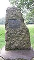
Plaque recording the excavations by Philip Corder
