
Dewey–Humboldt, Arizona facts for kids
Quick facts for kids
Dewey–Humboldt, Arizona
|
||
|---|---|---|
|
Town
|
||

Town of Dewey-Humboldt historic marker
|
||
|
||

Location of Dewey–Humboldt in Yavapai County, Arizona
|
||
| Country | United States | |
| State | Arizona | |
| County | Yavapai | |
| Incorporated (town) | 2004 | |
| Area | ||
| • Total | 18.79 sq mi (48.68 km2) | |
| • Land | 18.79 sq mi (48.68 km2) | |
| • Water | 0.00 sq mi (0.00 km2) | |
| Elevation | 4,581 ft (1,396 m) | |
| Population
(2020)
|
||
| • Total | 4,326 | |
| • Density | 230.18/sq mi (88.87/km2) | |
| Time zone | UTC-7 (MST) | |
| ZIP code |
86329
|
|
| Area code(s) | 928 | |
| FIPS code | 04-19145 | |
| GNIS feature ID | 2412424 | |


Dewey–Humboldt is a town in Yavapai County, Arizona, in the United States. In 2020, about 4,326 people lived there. The town was officially formed in 2004. It brought together two older communities, Dewey and Humboldt. These towns are located near each other in the Agua Fria River Valley. They are about 15 miles east of Prescott.
Contents
A Quick Look at Dewey–Humboldt's Past
Dewey–Humboldt became an official town on December 20, 2004. It was created by joining the two nearby towns of Dewey and Humboldt. These towns are in the Agua Fria River Valley. They are about 15 miles east of Prescott.
Early Days and Gold Discoveries
The area around Dewey was settled in 1863. This happened after gold was found on Lynx Creek. A pioneer named King Woolsey started the Agua Fria Ranch. He built his ranch house using stones from old ruins. He also set up an irrigation system from the Agua Fria River. Woolsey brought some of the first cattle to Yavapai County.
He also built a small mill to process gold ores. He had a water-powered grist mill too. Woolsey's ranch was later sold. The ruins of his ranch house can still be seen today. They are listed on the National Register of Historic Places.
Growth of the Towns
By 1875, a post office was set up in the valley. It was called "Agua Fria." Farmers used water to grow many crops. In the mid-1870s, a small furnace was built. It processed silver-lead ores from what would become the Iron King mine. This showed the area had valuable minerals.
The region became less isolated in 1898. The Prescott & Eastern Railroad was built. It went from near Prescott to Mayer. The railroad added stops at Cherry Creek Siding and Val Verde. The Agua Fria post office closed in 1895. A new post office opened in 1898. The community was renamed Dewey. This was likely to honor Admiral Dewey after his victory in the Battle of Manila. Another post office opened in Val Verde in 1899.
The Mining Boom in Humboldt
In 1902, a large smelter in Val Verde burned down. A new company built an even bigger smelter. This new plant processed ores from local mines and other areas. The Val Verde post office was renamed Humboldt in 1905. This name honored Baron Alexander von Humboldt. He was a famous explorer.
The town of Humboldt grew quickly. The smelter and railroads led to a big mining boom. By 1907, Humboldt had 1,000 people. The town held a Labor Day celebration with a parade. This became a yearly tradition.
Challenges and Revival
The mining boom slowed down after 1907. But it picked up again during World War I. The smelter worked with the Blue Bell Mine. This mine produced copper. The train connected the mine to the smelter. This helped the town stay strong. Many old buildings in Humboldt are from this time.
The Iron King Mine was also very important. It closed for a while after 1907. It reopened during World War I. After the war, the smelter and mine closed again. By 1930, Humboldt's population dropped to 300.
The mine reopened in 1934. It became the most productive mine in the area. It produced a lot of gold, silver, lead, and zinc. The Iron King Mine finally closed in 1968.
Modern Times
Today, the old mine tailings are used to make Ironite fertilizer. There have been some concerns about the safety of this fertilizer. It was even banned in Canada.
The railroad tracks were removed in 1971. In Humboldt, one tall smelter smokestack still stands. It reminds everyone of the town's mining past. Farming continued in the area until 2006. The last farm was sold for new buildings. Now, Dewey is mostly a residential area.
Where is Dewey–Humboldt?
Dewey–Humboldt is located at coordinates 34°31′57″N 112°15′9″W / 34.53250°N 112.25250°W. The town covers about 18.6 square miles (48.68 square kilometers) of land.
Weather in Dewey–Humboldt
| Climate data for Dewey-Humboldt, AZ, normals | |||||||||||||
|---|---|---|---|---|---|---|---|---|---|---|---|---|---|
| Month | Jan | Feb | Mar | Apr | May | Jun | Jul | Aug | Sep | Oct | Nov | Dec | Year |
| Mean daily maximum °F (°C) | 51.6 (10.9) |
55.0 (12.8) |
61.0 (16.1) |
68.9 (20.5) |
78.1 (25.6) |
87.7 (30.9) |
90.8 (32.7) |
88.2 (31.2) |
82.6 (28.1) |
72.3 (22.4) |
60.0 (15.6) |
50.9 (10.5) |
70.6 (21.4) |
| Mean daily minimum °F (°C) | 28.5 (−1.9) |
30.6 (−0.8) |
34.9 (1.6) |
40.8 (4.9) |
49.5 (9.7) |
57.8 (14.3) |
64.0 (17.8) |
62.8 (17.1) |
56.1 (13.4) |
44.8 (7.1) |
34.2 (1.2) |
27.8 (−2.3) |
44.3 (6.8) |
| Average precipitation inches (mm) | 1.4 (36) |
1.6 (41) |
1.5 (38) |
0.7 (18) |
0.5 (13) |
0.4 (10) |
2.1 (53) |
2.7 (69) |
1.6 (41) |
1.1 (28) |
1.1 (28) |
1.2 (30) |
15.9 (405) |
| Source: Bestplaces.net | |||||||||||||
People Living in Dewey–Humboldt
| Historical population | |||
|---|---|---|---|
| Census | Pop. | %± | |
| 1990 | 3,640 | — | |
| 2000 | 3,453 | −5.1% | |
| 2010 | 3,894 | 12.8% | |
| 2020 | 4,326 | 11.1% | |
| U.S. Decennial Census | |||
In 2000, there were 6,295 people living in the area. There were 2,795 households. About 16.8% of households had children under 18. Most households (63.8%) were married couples. The average household had 2.25 people.
The median age in 2000 was 54 years old. About 16.8% of the population was under 18. About 31.4% were 65 or older. The median income for a household was $36,839.
Schools in Dewey–Humboldt
The schools in Dewey–Humboldt are part of the Humboldt Unified School District.
Important Places and Farms
King S. Woolsey was a famous pioneer. His ranch was located near the Old Black Canyon Highway. This is now part of Dewey-Humboldt.
Later, in 1946, Woolsey's land became Young's Farm. This was a family farm. They sold turkeys and pumpkins. Young's Farm was a popular place. People came for hay rides and pumpkin patches. They also enjoyed the country restaurant. The farm held a "Pumpkin Fest" every October. It attracted many visitors.
Young's Farm was sold to developers in 2006. It closed down. But in 2011, Mortimer Family Farms bought it. They continued the farming tradition. They sell sweet corn in summer and pumpkins in fall. The ruins of King Woolsey's ranch house are still there. You can see them from the Old Black Canyon Highway.
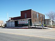
Images for kids
The following are images of some of the remaining original structures of both Dewey and Humboldt.

-
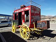
19th Century Stagecoach which serviced Dewey
-
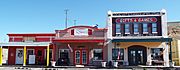
Dewey Original Town site
-
Dewey Original Town site
-
Dewey Original Town site
-
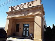
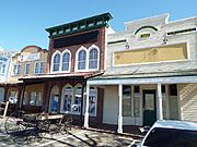
Humboldt Bank Building – 1918
-
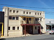
Humboldt Hotel – 1917
-
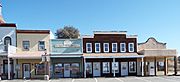
Humboldt Post Office – 1910
-
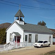
Humboldt Agua Fria Christian Church – 1907
-
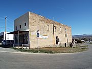
Humboldt Commercial Building – 1910
-
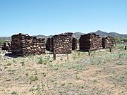
Ruins of King Woolsey's ranch
-
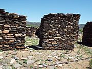
Different view of the ruins of King Woolsey's ranch
-
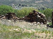
Different view of the ruins of King Woolsey's ranch


See also
 In Spanish: Dewey-Humboldt para niños
