
Diego Ramírez de Arellano facts for kids
Quick facts for kids
Diego Ramírez de Arellano
|
|
|---|---|

Ramírez de Arellano (center) from an 18th-century ceramic altarpiece commemorating the sons of Xàtiva
|
|
| Born | c. 1580 |
| Died | 27 May 1624 (aged 43–44) |
| Nationality | Spanish |
| Occupation | Navigator |
| Known for | Discovery of the Diego Ramírez Islands |
Diego Ramírez de Arellano (around 1580 – 27 May 1624) was a Spanish sailor and mapmaker. He became famous for guiding the Garcia de Nodal expedition. This trip explored the area near the Strait of Magellan.
The expedition found the Diego Ramírez Islands. These islands were the southernmost point visited by Europeans for a long time. No one went further south until Captain James Cook found the South Sandwich Islands in 1775.
Contents
Exploring the Southern Seas
The Dangerous Strait of Magellan
The Strait of Magellan was found by the Spanish in 1520. It was a sea route connecting the Atlantic and Pacific oceans. This narrow passage runs between South America and the archipelago of Tierra del Fuego.
The strait was about 4 miles wide on average. But it was much narrower in some spots. Strong, stormy winds and tricky ocean currents made it very dangerous for sailing ships.
In the early 1600s, Dutch sailors Jacob Le Maire and Willem Schouten found a new, safer route further south. King Philip III of Spain wanted to check this new discovery. So, he sent an expedition of two ships. They left Lisbon in September 1618.
The Garcia de Nodal Expedition

Diego Ramírez de Arellano was born in Xàtiva, Spain, around 1580. He was chosen as the main pilot for an important trip in 1618. This expedition was led by brothers Bartolomé and Gonzalo García del Nodal. Their goal was to explore the area around the Strait of Magellan.
The expedition used two small ships called caravels. Diego Ramírez was in charge of watching the stars and making maps. He had help from Juan Manso and seven other pilots. They used modern tools called astrolabes. These tools helped them measure angles very accurately.
The ships left Lisbon on September 27, 1618. They returned to Sanlúcar de Barrameda nine months later, on July 8, 1619. The two caravels sailed smoothly to the southern tip of South America. They stopped for a few days in Rio de Janeiro along the way.
They left Rio de Janeiro on December 6, 1618. On January 6, 1619, they found islands they named Los Reyes. By January 22, they reached Cape Le Maire, which they called Cape San Vicente. The ships sailed through the San Vicente Strait and then west into the Pacific Ocean. This journey proved that the new route found by the Dutch was real.
On February 10, 1619, they found a small group of islands to the southwest. They named these islands the Diego Ramírez Islands, after their mapmaker.
After that, the expedition sailed northwest. They entered the western part of the Magellan Strait. Then they sailed eastward through the strait to return to the Atlantic. The journey was tough due to the harsh weather, but they faced no major problems.
Ramírez, with Juan Manso's help, gathered information to draw the first full sea chart of southern Patagonia. Their journey also showed that Tierra del Fuego was an island. Before, people thought it was part of a huge southern continent called "Terra Australis".
Later Life and Achievements
A New Role and a Stormy Trip
After his famous voyage, Diego Ramírez de Arellano continued his important work. In 1619, he was made an honorary captain in the Spanish army. He also became an "almirante," which is like an admiral. He was still a pilot and was recommended as a mapmaker and navigation expert.
In December 1619, Diego Ramírez joined a new fleet of ships. This fleet was supposed to sail to the Philippines. But on January 3, 1620, they ran into a terrible storm. The ships were scattered, and many people died. Only two small boats from one ship survived. Diego Ramírez de Arellano was on one of them. He managed to swim to shore.
Important Contributions
From 1620 to 1624, Ramírez worked as the main pilot for the House of Trade in Seville. This was a very important job. He died in Seville on May 27, 1624, while still working.
Diego Ramírez de Arellano made big contributions to navigation. He accurately figured out latitudes and longitudes. He also corrected many navigation charts. He named many places, including the Isla de Xátiva, which is now the Isla Grande de Tierra del Fuego. He also named the Ildefonso Islands and the Strait of Saint Vincent the Martyr. This strait is now known as Le Maire Strait.
Captain James Burney said that finding the Diego Ramírez Islands was the most amazing part of the voyage. For 150 years, these islands were the southernmost points on any map.
Ramírez also published a chart of magnetic variations. This was the first such chart for that region. The Nodal brothers' story of the voyage was published in 1621. Ramírez's own detailed story was kept secret for a long time. It was finally published in full in 2011. It tells a tale of great adventure.
Images for kids
-
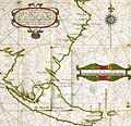
Part of the map by Diego Ramírez de Arellano showing the "Isla de Xativa", today called Tierra del Fuego
-
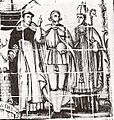
Ramírez de Arellano (center) from an 18th-century ceramic altarpiece commemorating the sons of Xàtiva
See also
 In Spanish: Diego Ramírez de Arellano para niños
