
Dili Municipality facts for kids
Quick facts for kids
Dili
|
|
|---|---|
|
|

Cathedral of Dili
|
|

|
|
|
OpenStreetMap
|
|
| Country | |
| Capital | Dili |
| Administrative posts |
|
| Area | |
| • Total | 224.0 km2 (86.5 sq mi) |
| Area rank | 13th |
| Population
(2022)
|
|
| • Total | 268,005 |
| • Rank | 1st |
| • Density | 1,196.45/km2 (3,098.8/sq mi) |
| • Density rank | 1st |
| Households (2015 census) | |
| • Total | 42,485 |
| • Rank | 1st |
| Time zone | UTC+09:00 (TLT) |
| ISO 3166 code | TL-DI |
| HDI (2017) | 0.733 high · 1st |
Dili Municipality (also called Município Díli in Portuguese and Munisípiu Dili in Tetum) is one of the 14 main areas, or municipalities, in Timor-Leste. It is home to the country's capital city, Dili. In 2015, about 277,279 people lived here. Most of them live in the capital city itself.
Contents
Where Does the Name Dili Come From?
People have different ideas about how Dili got its name. One popular idea is that it comes from the Tetum word ai-dila. This word means "pawpaw," which is a type of fruit. However, some experts think this might not be the real reason. Another idea is that the name Dili comes from the Bunak word zili. This word means "cliff." This makes sense because there is a large cliff behind the city. Before Tetum was widely spoken in the area, a language similar to Bunak was used.
Some people also suggest the name comes from the Portuguese word Dali. This word might be similar to the Tetum phrase tali akar, meaning "hemp rope." Long ago, there were many hemp trees in the area now known as Caicoli. Local people used to have special ceremonies and offerings for these trees. They believed the Portuguese word Dali meant "sacred eye," and so they used it for the area's name.
Geography of Dili

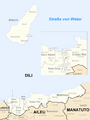
Dili is the second smallest municipality in East Timor by land area. It covers about 224.0 square kilometers (about 86 square miles). Even though it's small, it has the largest population in the country. Dili is located on the northern coast of Timor island. It faces the Ombai Strait, which is a body of water. To the east, Dili borders the Manatuto area. To the south, it borders Aileu. And to the west, it borders Liquiçá.
Atauro Island is located north of Dili, across from the capital city. Until the end of 2021, Atauro Island was part of Dili's administrative areas. Now, Atauro Island is its own separate municipality. Dili is very important to East Timor. It is the main center for both the country's economy and its government.
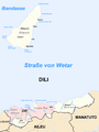
Administrative Posts
The Dili Municipality is divided into smaller areas called administrative posts. These used to be known as sub-districts. The administrative posts are:
- Cristo Rei
- Dom Aleixo
- Metinaro
- Nain Feto
- Vera Cruz
These administrative posts are further divided into 31 "sucos," which are like villages or neighborhoods.
Images for kids
-
Subdivisions of the municipality
-
Cities in the municipality of Dili


See also
 In Spanish: Distrito de Dili para niños
