
Don Alonso facts for kids
Quick facts for kids
Don Alonso
|
|
|---|---|
|
Barrio
|
|

Dos Bocas Lake
|
|

Location of Don Alonso within the municipality of Utuado shown in red
|
|

Don Alonso
Location in Caribbean
|
|
| Commonwealth | |
| Municipality | |
| Area | |
| • Total | 7.24 sq mi (18.8 km2) |
| • Land | 7.03 sq mi (18.2 km2) |
| • Water | 0.21 sq mi (0.5 km2) |
| Elevation | 1,152 ft (351 m) |
| Population
(2010)
|
|
| • Total | 900 |
| • Density | 128/sq mi (49/km2) |
| Source: 2010 Census | |
| Time zone | UTC−4 (AST) |
Don Alonso is a small community, also called a barrio, located in the town of Utuado, Puerto Rico. In 2010, about 900 people lived there. It's a part of Puerto Rico, which is a commonwealth of the United States.
History of Don Alonso
Puerto Rico became a part of the United States after the Spanish–American War. This happened because of a peace agreement called the Treaty of Paris of 1898. Don Alonso, like the rest of Puerto Rico, became an unincorporated territory of the U.S.
In 1899, the U.S. government took a count of all the people living in Puerto Rico. This count is called a census. The census found that 1,610 people lived in Don Alonso barrio at that time. The population has changed over the years, as you can see in the table below.
| Historical population | |||
|---|---|---|---|
| Census | Pop. | %± | |
| 1900 | 1,610 | — | |
| 1980 | 1,187 | — | |
| 1990 | 911 | −23.3% | |
| 2000 | 897 | −1.5% | |
| 2010 | 900 | 0.3% | |
| U.S. Decennial Census 1899 (shown as 1900) 1910-1930 1930-1950 1980-2000 2010 |
|||
Gallery
-
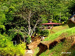
Gazebos near Dos Bocas Lake, a great place to relax.
-
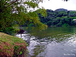
The beautiful Dos Bocas Lake in Don Alonso.
.jpg)

See also
 In Spanish: Don Alonso para niños
- List of communities in Puerto Rico
