Doniphan, Nebraska facts for kids
Quick facts for kids
Doniphan, Nebraska
|
|
|---|---|
|
Village
|
|

Downtown Doniphan: West Plum Street, seen from the southwest, March 2010
|
|

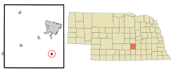
Location of Doniphan, Nebraska
|
|
| Country | United States |
| State | Nebraska |
| County | Hall |
| Area | |
| • Total | 0.49 sq mi (1.28 km2) |
| • Land | 0.49 sq mi (1.28 km2) |
| • Water | 0.00 sq mi (0.00 km2) |
| Elevation | 1,942 ft (592 m) |
| Population
(2020)
|
|
| • Total | 809 |
| • Density | 1,634.34/sq mi (631.24/km2) |
| Time zone | UTC-6 (Central (CST)) |
| • Summer (DST) | UTC-5 (CDT) |
| ZIP code |
68832
|
| Area code(s) | 402 |
| FIPS code | 31-13365 |
| GNIS feature ID | 2398736 |
| Website | https://doniphanne.com/ |
Doniphan is a small village located in Hall County, Nebraska, in the United States. In 2020, about 809 people lived there. Doniphan is part of the larger Grand Island area.
Contents
History of Doniphan
The town of Doniphan was first planned in 1879 by a local pioneer named William J. Burger. He wanted it to be a stop between the cities of Hastings and Grand Island. This was along the St. Joseph and Grand Island Railroad line.
The village was named after Colonel John Doniphan. He was a lawyer from Saint Joseph, Missouri who worked for the railroad company. Doniphan officially became a village in 1884.
Geography of Doniphan
Doniphan is located in Nebraska. According to the United States Census Bureau, the village covers a total area of about 0.51 square miles (1.28 square kilometers). All of this area is land.
People in Doniphan
| Historical population | |||
|---|---|---|---|
| Census | Pop. | %± | |
| 1880 | 85 | — | |
| 1890 | 437 | 414.1% | |
| 1900 | 473 | 8.2% | |
| 1910 | 399 | −15.6% | |
| 1920 | 482 | 20.8% | |
| 1930 | 436 | −9.5% | |
| 1940 | 395 | −9.4% | |
| 1950 | 412 | 4.3% | |
| 1960 | 390 | −5.3% | |
| 1970 | 542 | 39.0% | |
| 1980 | 696 | 28.4% | |
| 1990 | 736 | 5.7% | |
| 2000 | 763 | 3.7% | |
| 2010 | 829 | 8.7% | |
| 2020 | 809 | −2.4% | |
| U.S. Decennial Census | |||
Doniphan's Population in 2010
In 2010, there were 829 people living in Doniphan. These people lived in 338 different homes, and 217 of these were families. The village had about 1,625 people per square mile.
Most of the people in Doniphan were White (95.8%). A small number were Native American (1.1%) or from other races (2.3%). About 4.3% of the population was Hispanic or Latino.
Many homes (36.4%) had children under 18 living there. More than half (51.2%) were married couples. About 31.7% of all homes had just one person living in them. The average home had 2.45 people, and the average family had 3.12 people.
The average age of people in Doniphan was 34 years old. About 28.5% of the residents were under 18. About 12.2% were 65 years old or older. The village had slightly more males (50.2%) than females (49.8%).
Education in Doniphan
The main school in the area is Doniphan Trumbull School. It is a public school located right in Doniphan. This school teaches about 222 students from 7th to 12th grade. There is one teacher for every 11 students, which means students can get a lot of help.
See also

- In Spanish: Doniphan (Nebraska) para niños
 | Frances Mary Albrier |
 | Whitney Young |
 | Muhammad Ali |

