Doonie Point facts for kids
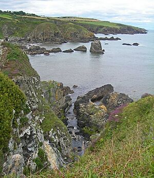
Doonie Point is a rocky piece of land that sticks out into the sea. This type of landform is called a headland. It is located about 1.5 kilometers south of the village of Muchalls in Aberdeenshire, Scotland.
From the top of the cliffs at Doonie Point, you can see amazing views. To the north, you'll spot places like Grim Brigs, Brown Jewel, and the coast near Newtonhill. Looking south, you can see the Castle Rock of Muchalls and the rugged North Sea coastline stretching towards Stonehaven.
Close to Doonie Point, there are some interesting old buildings. These include the Chapel of St Mary and St Nathalan, Muchalls Castle, and the Mill of Muchalls. Doonie Point is also a popular spot for rock climbing. It is even listed for marine rescue activities in this part of northeast Scotland.
A Look at History
Doonie Point is located just east of an ancient path called the Causey Mounth. This old road was built on high ground. It was the only main route during the Middle Ages that connected coastal areas south of Stonehaven to Aberdeen.
This historic path specifically linked the River Dee crossing (where the Bridge of Dee is today) with Portlethen Moss, Muchalls Castle, and Stonehaven further south. In 1639, this very route was used by a large army of 9,000 men. They were led by William Keith, 7th Earl Marischal and the Marquess of Montrose during a time of conflict in Scotland.
 | Toni Morrison |
 | Barack Obama |
 | Martin Luther King Jr. |
 | Ralph Bunche |


