Grim Brigs facts for kids

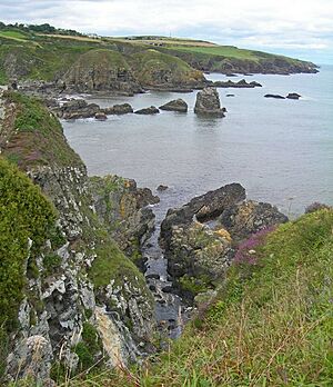
Grim Brigs is a rocky piece of land that sticks out into the North Sea in Muchalls, Scotland. This type of land is called a headland. You can find it by its grid reference, NO9091.
Close to Grim Brigs, there are some interesting old places. These include St. Ternan's Church, Muchalls Castle, and Elsick House. About one kilometre inland, there's an old road from the medieval times called the Causey Mounth. This was a special path used by people moving animals.
The rocks at Grim Brigs are very hard. They are part of the land north of the Highland Boundary Fault. This fault line is like a natural border. It separates the Scottish Highlands from the Lowlands. This important fault line reaches the North Sea about four kilometres south of Grim Brigs. It is near the Chapel of St. Mary and St. Nathalan.
Grim Brigs: A Look at Its Past
Grim Brigs is located a few kilometres east of the very old Causey Mounth trackway. This road was built a long time ago in the medieval period. It was the only way to travel easily from the coast south of Stonehaven to Aberdeen.
This old path connected important places. It linked the River Dee crossing, where the Bridge of Dee is today. From there, it went through Portlethen Moss, past Muchalls Castle, and then south to Stonehaven.
An important event happened on this route in 1639. Two leaders, William Keith, 7th Earl Marischal and the Marquess of Montrose, used this path. They led a large Covenanter army of 9000 men. This army was part of a big conflict called the Civil War.
 | Emma Amos |
 | Edward Mitchell Bannister |
 | Larry D. Alexander |
 | Ernie Barnes |

