Dover, New York facts for kids
Quick facts for kids
Dover, New York
|
||
|---|---|---|

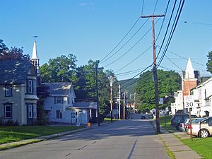
Downtown Dover Plains
|
||
|
||

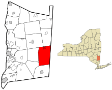
Location of Dover, New York
|
||
| Country | United States | |
| State | New York | |
| County | Dutchess | |
| Government | ||
| • Type | Town Council | |
| Area | ||
| • Total | 56.33 sq mi (145.90 km2) | |
| • Land | 55.18 sq mi (142.92 km2) | |
| • Water | 1.15 sq mi (2.98 km2) | |
| Elevation | 568 ft (173 m) | |
| Population
(2020)
|
||
| • Total | 8,415 | |
| • Density | 152.50/sq mi (58.88/km2) | |
| Time zone | UTC-5 (Eastern (EST)) | |
| • Summer (DST) | UTC-4 (EDT) | |
| FIPS code | 36-027-20819 | |
| GNIS feature ID | 0978906 | |
Dover is a town located in Dutchess County, New York, United States. In 2020, about 8,415 people lived here. The town was named after Dover in England. This was the hometown of one of the first people to settle in the area.
Dover is on the eastern side of Dutchess County. It is north of Pawling and south of Amenia. The state of Connecticut is just to its east.
Contents
History of Dover
Early Settlers and Town Formation
In 1637, the Pequot people moved to what is now Dover. They had been forced out of their homes in Connecticut. A leader named Gideon Mauwee guided them for some time.
The town of Dover was officially created in 1807. It was formed from a part of the town of Pawling. The very first town meeting happened at the home of John Preston. His home was built around 1730. Today, it is a famous inn and restaurant called Old Drovers Inn.
The Harlem Valley Center
The Harlem Valley Psychiatric Center was a large hospital. It operated from 1924 to 1994. This center provided many jobs for people in Dover. It also helped people from nearby areas.
When the center closed in 1994, it affected many local businesses. Many of the old brick buildings are still standing. In 2003, a company bought the property. Later, in 2013, Olivet University bought it. Now, it is known as the Evangelical Center. The buildings are being fixed up and made new again.
Geography of Dover
Land and Water Features
Dover covers a total area of about 145.9 square kilometers (56.3 square miles). Most of this area, about 142.9 square kilometers (55.2 square miles), is land. The rest, about 3.0 square kilometers (1.15 square miles), is water.
The Ten Mile River flows through the town. It starts in the north and goes through the center of Dover. Then, it turns east and flows into Connecticut. It eventually joins the Housatonic River.
The eastern edge of Dover is the border with Connecticut.
The Appalachian Trail
The famous Appalachian Trail also goes through the town of Dover. This long hiking trail stretches across many states.
Dover's Population
How Many People Live Here?
| Historical population | |||
|---|---|---|---|
| Census | Pop. | %± | |
| 1820 | 2,193 | — | |
| 1830 | 2,198 | 0.2% | |
| 1840 | 2,000 | −9.0% | |
| 1850 | 2,146 | 7.3% | |
| 1860 | 2,805 | 30.7% | |
| 1870 | 2,279 | −18.8% | |
| 1880 | 2,281 | 0.1% | |
| 1890 | 1,863 | −18.3% | |
| 1900 | 1,959 | 5.2% | |
| 1910 | 2,016 | 2.9% | |
| 1920 | 1,710 | −15.2% | |
| 1930 | 3,775 | 120.8% | |
| 1940 | 7,385 | 95.6% | |
| 1950 | 7,460 | 1.0% | |
| 1960 | 8,776 | 17.6% | |
| 1970 | 8,475 | −3.4% | |
| 1980 | 7,261 | −14.3% | |
| 1990 | 7,778 | 7.1% | |
| 2000 | 8,565 | 10.1% | |
| 2010 | 8,699 | 1.6% | |
| 2020 | 8,415 | −3.3% | |
| U.S. Decennial Census | |||
In 2000, there were 8,565 people living in Dover. There were 3,034 households, which are groups of people living together. The population density was about 153.8 people per square mile.
The average age of people in Dover was 36 years old. About 29.2% of the population was under 18 years old.
Transportation in Dover
Roads for Travel
Dover has two main roads. Route 22 runs north to south through the town. It connects Dover to Pawling and Amenia. Route 343 also passes through the town. In 2006, Route 22 was repaved to make driving smoother.
Train Service
Metro-North Railroad's Harlem Line goes through Dover. This train line connects Dover to New York City. There are two train stations in town. They are the Harlem Valley – Wingdale station and the Dover Plains station. Trains run regularly, especially during busy times.
Bus Routes
Dover also has bus service. Dutchess County Public Transit's "D" route serves the town.
Communities and Locations in Dover
Here are some of the smaller areas and places you can find in Dover:
- Bains Corner: An area east of Dover Plains.
- Chestnut Ridge: In the northwestern part of town.
- Dogtail Corners: In the southeastern part of town.
- Dover Furnace: In the central part of town, west of Route 22.
- Dover Plains: A small village in the northeastern part of town.
- Duell Hollow: In the southeastern corner of town.
- Ellis Pond: A small lake in the southeastern part of town.
- Lake Weil: A small lake made by people in the southeastern part of town.
- Oniontown: A community in the northern part of town.
- South Dover: A small village in the eastern part of town.
- Webatuck: An area in the southeastern part of town near Route 55.
- Wingdale: A small village in the southern part of town on Route 22.
Camps
Camp Ramah in the Berkshires is a camp located in Wingdale. It is right on Lake Ellis.
Electric Power Facilities
Cricket Valley Energy Center
The Cricket Valley Energy Center is a large power plant in Dover. It was built to produce about 1,100 megawatts of electricity. This power plant started working in April 2020.
The plant uses natural gas to create electricity. It has three large turbines that spin to make power. It is located on a large piece of land that used to be an industrial area. The power it makes is sold to the electricity market in New York.
See also
 In Spanish: Dover (Nueva York) para niños
 | Dorothy Vaughan |
 | Charles Henry Turner |
 | Hildrus Poindexter |
 | Henry Cecil McBay |


