Dover Beaches South, New Jersey facts for kids
Quick facts for kids
Dover Beaches South, New Jersey
|
|
|---|---|

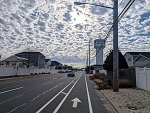
Route 35 southbound in the CDP
|
|

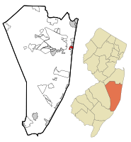
Map of Dover Beaches South CDP in Ocean County. Inset: Location of Ocean County in New Jersey.
|
|
| Country | |
| State | |
| County | Ocean |
| Township | Toms River |
| Area | |
| • Total | 1.01 sq mi (2.61 km2) |
| • Land | 0.62 sq mi (1.61 km2) |
| • Water | 0.39 sq mi (1.00 km2) 39.80% |
| Elevation | 3 ft (1 m) |
| Population
(2020)
|
|
| • Total | 1,331 |
| • Density | 2,139.87/sq mi (826.47/km2) |
| Time zone | UTC−05:00 (Eastern (EST)) |
| • Summer (DST) | UTC−04:00 (Eastern (EDT)) |
| FIPS code | 34-18151 |
| GNIS feature ID | 02389414 |
Dover Beaches South, often called Ortley Beach, is a community in Toms River, Ocean County, New Jersey. It is a special area that the United States Census Bureau counts as a "census-designated place" (CDP). In 2020, about 1,331 people lived there.
Dover Beaches South is located on the Barnegat Peninsula. This is a long, narrow strip of land. It separates Barnegat Bay from the Atlantic Ocean. Toms River Township has three main CDPs. These are Toms River CDP on the mainland, Dover Beaches North, and Dover Beaches South.
Contents
Where is Dover Beaches South?
Dover Beaches South is a small area. It covers about 1.61 square kilometers (0.62 square miles) of land. It also has about 1.00 square kilometer (0.39 square miles) of water. This means almost 40% of its total area is water!
The community is next to Lavallette and Seaside Heights. These are other towns along the Jersey Shore.
How Many People Live There?
| Historical population | |||
|---|---|---|---|
| Census | Pop. | %± | |
| 2000 | 1,594 | — | |
| 2010 | 1,209 | −24.2% | |
| 2020 | 1,331 | 10.1% | |
| Population sources: 2000-2010 2000 2010 2020 |
|||
In 2010, 1,209 people lived in Dover Beaches South. By 2020, the population grew slightly to 1,331 people. The average age of people living here in 2010 was about 56 years old.
What is the History of Ortley Beach?
Long ago, the area where Ortley Beach is now had a waterway called Cranberry Inlet. This inlet was important for boats. However, a big storm in 1812 closed it off.
Later, it became easier to get to this area. A railroad was built on the peninsula in 1883. Then, Route 35 was finished in 1913. These made it possible for people to visit.
Ortley Beach started to become a popular vacation spot in the 1940s and 1950s. People came to enjoy the beach and ocean.
In 2012, Hurricane Sandy caused a lot of damage. Many homes were hurt. After the storm, the community worked hard to rebuild. New homes were built, and the area changed a lot.
What is the Climate Like?
Dover Beaches South has a climate called "humid subtropical." This means it has hot summers and cool winters. It rains throughout the year.
- Summers: Summers are hot and a bit humid. A cool ocean breeze often blows in the afternoon. Sometimes, it can get very hot and sticky.
- Winters: Winters are cool. It can get very cold and windy sometimes.
- Rain and Snow: July is usually the wettest month, with many thunderstorms. From November to April, the area gets about 18 to 24 inches (46 to 61 cm) of snow. February is often the snowiest month.
The ocean water temperature changes throughout the year. It's coldest in February (around 36°F or 2°C) and warmest in August (around 72°F or 22°C).
What Plants Grow There?
The natural plants in Dover Beaches South are mostly "Northern Cordgrass" and "Coastal Prairie" plants. These are types of grasses and plants that grow well near the coast.
See also
 In Spanish: Dover Beaches South para niños


