kids encyclopedia robot

Drake County facts for kids

Kids Encyclopedia Facts
Quick facts for kids
Drake
New South Wales
Drake NSW.PNG
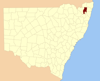
Location in New South Wales
Lands administrative divisions around Drake:
Buller Buller Rous
Clive Drake Richmond
Gough Gresham Clarence

Drake County is one of the 141 Cadastral divisions of New South Wales.

Drake County was named in honour of Sir Francis Drake (1540–1596). It is located to the north of parts of the Clarence River, Nymboida River and Mann River. It includes the Washpool National Park.

Parishes within this county

A full list of parishes found within this county; their current LGA and mapping coordinates to the approximate centre of each location is as follows:

Parish LGA Coordinates
Albert Glen Innes Severn Council 29°23′54″S 152°21′04″E / 29.39833°S 152.35111°E / -29.39833; 152.35111 (Albert)
Alice Clarence Valley Council 29°02′54″S 152°38′04″E / 29.04833°S 152.63444°E / -29.04833; 152.63444 (Alice)
Black Camp Kyogle Council 28°48′54″S 152°43′04″E / 28.81500°S 152.71778°E / -28.81500; 152.71778 (Black Camp)
Cangai Clarence Valley Council 29°36′54″S 152°30′04″E / 29.61500°S 152.50111°E / -29.61500; 152.50111 (Cangai)
Carnham Clarence Valley Council 29°16′54″S 152°30′04″E / 29.28167°S 152.50111°E / -29.28167; 152.50111 (Carnham)
Chauvel Tenterfield Shire Council 28°55′54″S 152°32′04″E / 28.93167°S 152.53444°E / -28.93167; 152.53444 (Chauvel)
Churchill Clarence Valley Council 29°10′54″S 152°30′04″E / 29.18167°S 152.50111°E / -29.18167; 152.50111 (Churchill)
Coombadjha Clarence Valley Council 29°22′54″S 152°28′04″E / 29.38167°S 152.46778°E / -29.38167; 152.46778 (Coombadjha)
Coongbar Clarence Valley Council 29°04′54″S 152°42′04″E / 29.08167°S 152.70111°E / -29.08167; 152.70111 (Coongbar)
Cooraldooral Glen Innes Severn Council 29°34′54″S 152°16′04″E / 29.58167°S 152.26778°E / -29.58167; 152.26778 (Cooraldooral)
Dandahra Clarence Valley Council 29°29′54″S 152°26′04″E / 29.49833°S 152.43444°E / -29.49833; 152.43444 (Dandahra)
Drake Tenterfield Shire Council 29°00′54″S 152°25′04″E / 29.01500°S 152.41778°E / -29.01500; 152.41778 (Drake)
Dunbar Tenterfield Shire Council 28°57′54″S 152°31′04″E / 28.96500°S 152.51778°E / -28.96500; 152.51778 (Dunbar)
Ewingar Clarence Valley Council 29°05′54″S 152°30′04″E / 29.09833°S 152.50111°E / -29.09833; 152.50111 (Ewingar)
Fairfield Tenterfield Shire Council 28°54′54″S 152°27′04″E / 28.91500°S 152.45111°E / -28.91500; 152.45111 (Fairfield)
Hamilton Tenterfield Shire Council 29°01′54″S 152°30′04″E / 29.03167°S 152.50111°E / -29.03167; 152.50111 (Hamilton)
Hassan Clarence Valley Council 29°20′54″S 152°45′04″E / 29.34833°S 152.75111°E / -29.34833; 152.75111 (Hassan)
Hongkong Tenterfield Shire Council 29°06′54″S 152°24′04″E / 29.11500°S 152.40111°E / -29.11500; 152.40111 (Hongkong)
Keybarbin Clarence Valley Council 29°06′54″S 152°38′04″E / 29.11500°S 152.63444°E / -29.11500; 152.63444 (Keybarbin)
Malara Tenterfield Shire Council 29°12′54″S 152°22′04″E / 29.21500°S 152.36778°E / -29.21500; 152.36778 (Malara)
Mookima Clarence Valley Council 29°14′54″S 152°43′04″E / 29.24833°S 152.71778°E / -29.24833; 152.71778 (Mookima)
Neville Clarence Valley Council 29°15′54″S 152°46′04″E / 29.26500°S 152.76778°E / -29.26500; 152.76778 (Neville)
Ogilvie Clarence Valley Council 29°11′54″S 152°38′04″E / 29.19833°S 152.63444°E / -29.19833; 152.63444 (Ogilvie)
Picarbin Kyogle Council 28°57′54″S 152°36′04″E / 28.96500°S 152.60111°E / -28.96500; 152.60111 (Picarbin)
Pikapene Kyogle Council 28°58′54″S 152°42′04″E / 28.98167°S 152.70111°E / -28.98167; 152.70111 (Pikapene)
Plevna Clarence Valley Council 29°17′54″S 152°22′04″E / 29.29833°S 152.36778°E / -29.29833; 152.36778 (Plevna)
Pucka Clarence Valley Council 29°20′54″S 152°35′04″E / 29.34833°S 152.58444°E / -29.34833; 152.58444 (Pucka)
Puhoi Clarence Valley Council 29°35′54″S 152°24′04″E / 29.59833°S 152.40111°E / -29.59833; 152.40111 (Puhoi)
Pulganbar Clarence Valley Council 29°26′54″S 152°41′04″E / 29.44833°S 152.68444°E / -29.44833; 152.68444 (Pulganbar)
Richmond Glen Innes Severn Council 29°29′54″S 152°21′04″E / 29.49833°S 152.35111°E / -29.49833; 152.35111 (Richmond)
Rodgers Glen Innes Severn Council 29°38′54″S 152°14′04″E / 29.64833°S 152.23444°E / -29.64833; 152.23444 (Rodgers)
Rodham Clarence Valley Council 29°09′54″S 152°43′04″E / 29.16500°S 152.71778°E / -29.16500; 152.71778 (Rodham)
Sandilands Kyogle Council 28°54′54″S 152°42′04″E / 28.91500°S 152.70111°E / -28.91500; 152.70111 (Sandilands)
Sistova Tenterfield Shire Council 29°13′54″S 152°16′04″E / 29.23167°S 152.26778°E / -29.23167; 152.26778 (Sistova)
Tabulam Kyogle Council 28°52′54″S 152°37′04″E / 28.88167°S 152.61778°E / -28.88167; 152.61778 (Tabulam)
Timbarra Tenterfield Shire Council 28°52′54″S 152°30′04″E / 28.88167°S 152.50111°E / -28.88167; 152.50111 (Timbarra)
West Fairfield Tenterfield Shire Council 28°55′54″S 152°22′04″E / 28.93167°S 152.36778°E / -28.93167; 152.36778 (West Fairfield)
Yarrcalkiarra Clarence Valley Council 29°16′54″S 152°39′04″E / 29.28167°S 152.65111°E / -29.28167; 152.65111 (Yarrcalkiarra)
Yulgilbar Clarence Valley Council 29°16′54″S 152°34′04″E / 29.28167°S 152.56778°E / -29.28167; 152.56778
kids search engine
Drake County Facts for Kids. Kiddle Encyclopedia.