Drummond, Idaho facts for kids
Quick facts for kids
Drummond, Idaho
|
|
|---|---|

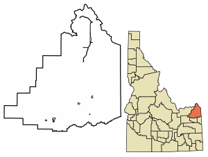
Location of Drummond in Fremont County, Idaho.
|
|
| Country | United States |
| State | Idaho |
| County | Fremont |
| Area | |
| • Total | 0.10 sq mi (0.25 km2) |
| • Land | 0.10 sq mi (0.25 km2) |
| • Water | 0.00 sq mi (0.00 km2) |
| Elevation | 5,604 ft (1,708 m) |
| Population
(2010)
|
|
| • Total | 16 |
| • Density | 166.67/sq mi (64.03/km2) |
| Time zone | UTC-7 (Mountain (MST)) |
| • Summer (DST) | UTC-6 (MDT) |
| ZIP code |
83420
|
| Area code(s) | 208 |
| FIPS code | 16-22780 |
| GNIS feature ID | 2410359 |
Drummond is a small city in Fremont County, Idaho, in the United States. In 2010, only 16 people lived there. It is part of the larger Rexburg, Idaho area.
Contents
About Drummond's Location
Drummond is a very small city. It covers an area of about 0.10 square miles (0.25 square kilometers). All of this area is land, meaning there are no lakes or large rivers within the city limits.
Where is Drummond?
You can find Drummond east of U.S. Highway 20. It is located right on State Highway 32.
Drummond's Weather
Drummond has a type of weather called a warm-summer humid continental climate. This means it has warm summers and cold, snowy winters.
| Climate data for Drummond, Idaho 1991–2020 simulated normals (5591 ft elevation) | |||||||||||||
|---|---|---|---|---|---|---|---|---|---|---|---|---|---|
| Month | Jan | Feb | Mar | Apr | May | Jun | Jul | Aug | Sep | Oct | Nov | Dec | Year |
| Mean daily maximum °F (°C) | 28.8 (−1.8) |
32.9 (0.5) |
42.3 (5.7) |
52.2 (11.2) |
62.6 (17.0) |
71.1 (21.7) |
81.3 (27.4) |
81.1 (27.3) |
71.1 (21.7) |
55.8 (13.2) |
40.1 (4.5) |
29.3 (−1.5) |
54.0 (12.2) |
| Daily mean °F (°C) | 19.6 (−6.9) |
22.8 (−5.1) |
31.3 (−0.4) |
39.9 (4.4) |
49.1 (9.5) |
56.5 (13.6) |
64.2 (17.9) |
63.1 (17.3) |
54.7 (12.6) |
42.4 (5.8) |
29.8 (−1.2) |
20.3 (−6.5) |
41.1 (5.1) |
| Mean daily minimum °F (°C) | 10.4 (−12.0) |
12.7 (−10.7) |
20.5 (−6.4) |
27.7 (−2.4) |
35.6 (2.0) |
41.9 (5.5) |
47.1 (8.4) |
45.3 (7.4) |
38.1 (3.4) |
29.1 (−1.6) |
19.6 (−6.9) |
11.3 (−11.5) |
28.3 (−2.1) |
| Average precipitation inches (mm) | 2.09 (53.07) |
1.54 (39.00) |
1.61 (41.02) |
1.90 (48.22) |
2.32 (58.99) |
1.85 (47.02) |
0.78 (19.75) |
0.90 (22.87) |
1.35 (34.22) |
1.74 (44.14) |
1.66 (42.06) |
2.29 (58.09) |
20.03 (508.45) |
| Average dew point °F (°C) | 15.3 (−9.3) |
16.5 (−8.6) |
21.6 (−5.8) |
25.3 (−3.7) |
32.4 (0.2) |
38.5 (3.6) |
40.8 (4.9) |
38.1 (3.4) |
32.7 (0.4) |
27.1 (−2.7) |
21.2 (−6.0) |
15.4 (−9.2) |
27.1 (−2.7) |
| Source: Prism Climate Group | |||||||||||||
People in Drummond
The number of people living in Drummond has changed a lot over the years. Here's a quick look at how the population has grown and shrunk:
| Historical population | |||
|---|---|---|---|
| Census | Pop. | %± | |
| 1920 | 115 | — | |
| 1930 | 61 | −47.0% | |
| 1940 | 66 | 8.2% | |
| 1950 | 59 | −10.6% | |
| 1960 | 31 | −47.5% | |
| 1970 | 13 | −58.1% | |
| 1980 | 25 | 92.3% | |
| 1990 | 37 | 48.0% | |
| 2000 | 15 | −59.5% | |
| 2010 | 16 | 6.7% | |
| 2019 (est.) | 16 | 0.0% | |
| U.S. Decennial Census | |||
What the 2010 Census Showed
In 2010, a count of the population (called a census) found 16 people living in Drummond. These people lived in 8 different homes, and 3 of these homes were families.
- Most people in Drummond (about 93.8%) were White.
- A small number (6.3%) were from two or more races.
The average age of people in Drummond was about 51.5 years old.
- About 18.7% of the people were under 18 years old.
- About 37.5% of the people were 65 years old or older.
- The number of males and females was equal, with 50% male and 50% female.
See also
 In Spanish: Drummond (Idaho) para niños
 | Misty Copeland |
 | Raven Wilkinson |
 | Debra Austin |
 | Aesha Ash |

