Dunbar, Nebraska facts for kids
Quick facts for kids
Dunbar, Nebraska
|
|
|---|---|
|
Village
|
|

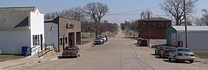
Downtown Dunbar.
|
|

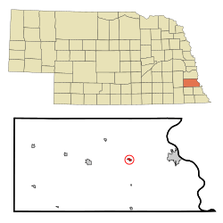
Location of Dunbar, Nebraska
|
|
| Country | United States |
| State | Nebraska |
| County | Otoe |
| Area | |
| • Total | 0.23 sq mi (0.60 km2) |
| • Land | 0.23 sq mi (0.60 km2) |
| • Water | 0.00 sq mi (0.00 km2) |
| Elevation | 1,083 ft (330 m) |
| Population
(2020)
|
|
| • Total | 165 |
| • Density | 717.39/sq mi (276.71/km2) |
| Time zone | UTC-6 (Central (CST)) |
| • Summer (DST) | UTC-5 (CDT) |
| ZIP code |
68346
|
| Area code(s) | 402 |
| FIPS code | 31-13855 |
| GNIS feature ID | 2398752 |
Dunbar is a small village located in Otoe County, Nebraska, in the United States. In 2020, about 165 people lived there.
Contents
Geography of Dunbar
Dunbar is a small place. It covers an area of about 0.23 square miles (0.60 square kilometers). All of this area is land, with no water.
People in Dunbar
| Historical population | |||
|---|---|---|---|
| Census | Pop. | %± | |
| 1900 | 208 | — | |
| 1910 | 216 | 3.8% | |
| 1920 | 312 | 44.4% | |
| 1930 | 292 | −6.4% | |
| 1940 | 336 | 15.1% | |
| 1950 | 228 | −32.1% | |
| 1960 | 232 | 1.8% | |
| 1970 | 252 | 8.6% | |
| 1980 | 216 | −14.3% | |
| 1990 | 171 | −20.8% | |
| 2000 | 237 | 38.6% | |
| 2010 | 187 | −21.1% | |
| 2020 | 165 | −11.8% | |
| U.S. Decennial Census | |||
How Many People Lived Here in 2010?
In 2010, there were 187 people living in Dunbar. These people lived in 70 different homes, and 50 of these were families.
- About 37% of homes had kids under 18 living there.
- Most homes (57%) were married couples living together.
- About 10% of homes had someone living alone who was 65 years old or older.
The average age of people in Dunbar was about 38.5 years old.
- About 25% of residents were under 18.
- About 28% were between 25 and 44 years old.
- Another 28% were between 45 and 64 years old.
- About 10% were 65 or older.
There were slightly more males (50.3%) than females (49.7%) in the village.
History of Dunbar
Dunbar was started in 1856 by a person named John Dunbar. It was first called Wilson, but then it was renamed after John Dunbar, who was one of the oldest residents.
In its early days, Dunbar was an important place for moving goods. It was a large "freighting depot" where items were stored and moved west from Nebraska City. The first railroad tracks were built in Dunbar in 1869. This helped connect the town to other places.
By the 1880s, Dunbar had many businesses:
- A grocery store
- A general store
- A restaurant
- Two hotels
- Five churches
- A pharmacy
- Two banks
- And more!
There were two big fires in 1884 and 1888. After these fires, people started building with brick and mortar to make buildings safer. A cemetery, called Delaware Cemetery, was built about one mile south of Dunbar.
In 1926, Dunbar celebrated its 70th birthday. They placed a special rock to remember John Dunbar. The Nebraska City High School Band played music, and there were other fun events.
On May 8, 1950, heavy flooding from Wilson Creek and Fox Creek caused a lot of damage in the village. Many buildings were washed away or nearly destroyed, and it was a very sad time for the community.
Later, in 1965, a new road called the Dunbar bypass was finished. This road went around the village instead of through it. This change made it harder for businesses in Dunbar, and the number of people living there went down.
Notable People from Dunbar
Some well-known people have connections to Dunbar:
- Sam Francis – An NFL football player.
- George H. Heinke – A Congressman who was born on a farm near Dunbar.
- William Henry Harrison – A state representative in Wyoming and a mayor of Pine Bluffs, Wyoming.
See also
 In Spanish: Dunbar (Nebraska) para niños
 | Charles R. Drew |
 | Benjamin Banneker |
 | Jane C. Wright |
 | Roger Arliner Young |

