Duncan, South Carolina facts for kids
Quick facts for kids
Duncan, South Carolina
|
|
|---|---|

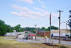
Main Street (SC 290)
|
|

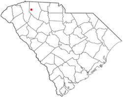
Location of Duncan, South Carolina
|
|
| Country | United States |
| State | South Carolina |
| County | Spartanburg |
| Area | |
| • Total | 5.52 sq mi (14.29 km2) |
| • Land | 5.42 sq mi (14.03 km2) |
| • Water | 0.10 sq mi (0.27 km2) |
| Elevation | 866 ft (264 m) |
| Population
(2020)
|
|
| • Total | 4,041 |
| • Density | 746.26/sq mi (288.12/km2) |
| Time zone | UTC-5 (Eastern (EST)) |
| • Summer (DST) | UTC-4 (EDT) |
| ZIP codes |
29334, 29390, 29391
|
| Area codes | 864, 821 |
| FIPS code | 45-21265 |
| GNIS feature ID | 1247572 |
Duncan is a town in Spartanburg County, South Carolina, United States. In 2010, about 3,181 people lived there. By 2020, the population had grown to 4,041 people.
Contents
History of Duncan
Early Beginnings and Name Changes
The story of Duncan began in 1811. A post office was set up on what is now Highway 290. A small community grew around it. Both the post office and the community were called New Hope.
Later, in 1854, the town changed its name. It became Vernonville or Vernonsville. This new name honored a local doctor, J.J. Vernon.
The Railroad Arrives
In the mid-1850s, there were plans for a railroad line. However, the Civil War stopped these plans. It wasn't until 1873 that the Atlanta and Richmond Railroad finally built a line through the town. This was a big step for the community.
How Duncan Got Its Name
After the Civil War, a man named Leroy Duncan moved to the town. He started buying a lot of land. Mr. Duncan was very ambitious. During celebrations for the new railroad, he made a promise. He said he would give land for new city streets. In return, the townspeople had to agree to rename the town after him. In 1881, the name change became official. That's how Vernonville became Duncan!
Growth and Important Milestones
Duncan quickly grew after its name change. Within two years, about 200 people lived there. The town had several general stores. There were also sawmills and flour mills. A cotton gin helped process cotton.
In 1881, the Rock Hill Negro School opened in Duncan. This was an important event for African-American history in Spartanburg County. The town officially received its charter in 1889. This meant it was recognized as a legal town.
In 1892, the Hughes Hotel opened. It became a popular spot in town. Travelers from the Greenville-Spartanburg road would often stay there.
Geography of Duncan
Duncan is located in South Carolina. Its exact spot is 34.934983 degrees North and 82.134801 degrees West. The town is mainly found where two highways meet. These are South Carolina Highway 290 and South Carolina Highway 292.
The town is west of Spartanburg. It is also east of Greenville. Duncan's borders stretch quite a bit. They go north past U.S. Route 29. They also extend south to Interstate 85. The Middle Tyger River flows through the northern part of Duncan. It also forms part of the town's border with Lyman to the northeast.
The United States Census Bureau says Duncan covers about 3.5 square miles (9.1 square kilometers). All of this area is land.
Population and People
How Duncan's Population Grew
The population of Duncan has changed a lot over the years. Here's how many people lived there during different census counts:
| Historical population | |||
|---|---|---|---|
| Census | Pop. | %± | |
| 1900 | 149 | — | |
| 1910 | 190 | 27.5% | |
| 1920 | 115 | −39.5% | |
| 1930 | 406 | 253.0% | |
| 1940 | 631 | 55.4% | |
| 1950 | 599 | −5.1% | |
| 1960 | 1,186 | 98.0% | |
| 1970 | 1,266 | 6.7% | |
| 1980 | 1,259 | −0.6% | |
| 1990 | 2,152 | 70.9% | |
| 2000 | 2,870 | 33.4% | |
| 2010 | 3,181 | 10.8% | |
| 2020 | 4,041 | 27.0% | |
| U.S. Decennial Census | |||
People in Duncan (2020 Census)
The 2020 United States census counted 4,041 people living in Duncan. There were 1,323 households and 843 families. The census also looks at the different backgrounds of people living in a town. This helps us understand the community better.
Here's a look at the different groups of people in Duncan in 2020:
| Race | Num. | Perc. |
|---|---|---|
| White (non-Hispanic) | 2,098 | 51.92% |
| Black or African American (non-Hispanic) | 1,235 | 30.56% |
| Native American | 8 | 0.2% |
| Asian | 58 | 1.44% |
| Pacific Islander | 4 | 0.1% |
| Other/Mixed | 202 | 5.0% |
| Hispanic or Latino | 436 | 10.79% |
Economy
Duncan is home to several important companies. These businesses help create jobs and support the town's economy. Some of the companies with North American headquarters in Duncan include:
- Staubli's
- Röchling Group
- Dräxlmaier Group
See also
 In Spanish: Duncan (Carolina del Sur) para niños

