Duncans Point facts for kids
Quick facts for kids |
|
|
Duncan's Landing Site
|
|

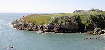
East side of Duncans Point in 2009
|
|
| Lua error in Module:Location_map at line 420: attempt to index field 'wikibase' (a nil value). | |
| Nearest city | Jenner, California |
|---|---|
| Area | 4 acres (1.6 ha) |
| NRHP reference No. | 71000206 |
| Added to NRHP | November 12, 1971 |
Duncans Point is a piece of land that sticks out into the Pacific Ocean in northern California. It's located in Sonoma County, about 45 miles (72 km) northwest of San Francisco. It's also about 20 miles (32 km) west of Santa Rosa.
This point is found roughly halfway between Bodega Head (to the south) and Goat Rock (to the north). You can easily reach it from State Route 1, a famous coastal highway. A small community called Ocean View is just north of Duncans Point.
The land that forms Duncans Point is about 300 yards (274 meters) long. It creates a sheltered, rocky area called Duncans Cove or Duncans Landing. This cove is part of the Sonoma Coast State Beach. Duncans Landing is known for being quite dangerous because of its very large waves and strong ocean currents.
A Look Back in Time
Duncans Point was once the southern border of the Pomo people's land. The Pomo are a group of Native Americans who lived in this area. Duncans Landing was also an important place for ships. Coastal ships would load up with food and lumber here to take to other places.
The landing site was recognized as a special historical place on November 12, 1971. It was added to the National Register of Historic Places.
How Duncans Point Formed
Duncans Point is an uplifted wave-cut platform. This means it's a flat area of rock that was once at sea level. Over a long time, ocean waves carved it flat. Then, the land slowly pushed upwards, lifting this flat area above the water.
 | Stephanie Wilson |
 | Charles Bolden |
 | Ronald McNair |
 | Frederick D. Gregory |

