
Dunlap, Philadelphia facts for kids
Quick facts for kids
Dunlap
|
|
|---|---|

Dunlap neighborhood
|
|
| Country | |
| State | Pennsylvania |
| County | Philadelphia |
| City | Philadelphia |
| ZIP code |
19139
|
| Area code(s) | 215, 267 and 445 |
Dunlap is a small neighborhood located in West Philadelphia, Pennsylvania. It is part of the big city of Philadelphia. This area is known for its quiet streets and community feel.
Contents
Where is the Dunlap Neighborhood?
Dunlap is found in the western part of Philadelphia. It sits between Haverford Avenue and Market Street. The neighborhood stretches from 46th Street to 52nd Street.
It is surrounded by other neighborhoods. To the north are Mill Creek and Haddington. Just south of Dunlap is Walnut Hill.
What is the History of Dunlap?
The neighborhood gets its name from an old school. This school was called the Thomas Dunlap School. It was a historic building in the area.
In 1991, the old school building was given a new life. It was restored and turned into homes for senior citizens. This helped keep a piece of the neighborhood's history alive.
How Do People Get Around in Dunlap?
Dunlap is part of the 19139 ZIP code area. It is also covered by the Philadelphia Police Department's 19th district. This district helps keep the community safe.
Residents and visitors can use public transportation. The neighborhood is served by SEPTA. You can catch a train at the 52nd Street station. This station is part of the Market–Frankford Line.
Images for kids
-
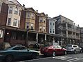
Houses in the Dunlap neighborhood

