
Dunneville, California facts for kids
Quick facts for kids
Dunneville, California
|
|
|---|---|

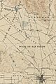
Tesquisquita Slough, Dunneville, and Pacecho Pass c. 1919
|
|

Dunneville, California
Location in California
|
|
| Country | United States |
| State | California |
| County | San Benito |
| Elevation | 190 ft (60 m) |
| Time zone | UTC-8 (Pacific (PST)) |
| • Summer (DST) | UTC-7 (PDT) |
| Area code(s) | 831 |
| GNIS feature ID | 222739 |
Dunneville is a historic place in San Benito County, California. It used to be a busy crossroads surrounded by fruit orchards. Dunneville is about 6.1 miles (9.8 km) north of Hollister.
Contents
What's in a Name?
Dunneville has had a few other names, like Chase's Corner and Four Corners. The name Dunneville comes from James Dunne, a wealthy local merchant and landowner. People say that his son, James Dunne Jr., was often found at the local bar. So, the area became known as Dunneville. Later, James Dunne's wife, Viola, gave land for a park in Hollister. She asked for it to be named Dunne Park in his honor.
A Look Back at Dunneville's History
Early Days and Native Americans
Long ago, before settlers arrived, a large Ohlone village called Poitoquix was in the Dunneville area. It might have been near Pacheco Creek. In 1774, a Spanish visitor described a large village with many trees and a pool of water nearby. This could have been Poitoquix.
Ranch Life and Stagecoaches
The land where Dunneville is today was once a big cattle ranch. It was called Rancho Bolsa de San Felipe. This ranch was given to Don Francisco Pérez Pacheco when California was part of Mexico.
Dunneville is located near Pacheco Creek. It was once a stop on the stagecoach route between Watsonville and Tres Pinos. In 1891, a traveler named Alice Culverwell wrote about passing through Dunneville on her way to Yosemite. She mentioned the beautiful scenery and how fine the weather was for camping.
Post Office and Community Life
In 1874, a post office was opened in Dunneville. The person who applied for it hoped Dunneville would grow into a village. They thought it would serve about 350 people. However, the post office closed just one year after San Benito County was officially formed in 1874.

In 1893, the San Felipe Chapel was built in Dunneville. It was made of redwood and had a beautiful Victorian style. The church was used until 1927. Later, in the 1970s, students from Gavilan College carefully took the church apart. They then rebuilt it on the college grounds. More work was done on the church in 2005.
Dunneville also had a store that opened in 1910. It was once famous for a restaurant called Grandma's Fried Chicken. There was also an old barn with huge cottonwood trees. A bar and dance hall stood at the main intersection from the 1880s until 1979. In 1917, the hall hosted a farewell party for local young men going to World War I. The soil around Dunneville was very good for growing fruit. Farmers grew many prunes, peaches, and pears there.

Airfield History
In the 1920s, Turner Airfield was located between Dunneville and Hollister. This airfield later became Naval Auxiliary Air Station Hollister. Today, it is known as Hollister Municipal Airport.
Images for kids
-
Tesquisquita Slough, Dunneville, and Pacecho Pass c. 1919
