Dutton Island facts for kids

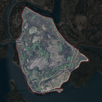
USGS aerial imagery of Dutton Island.
|
|
| Geography | |
|---|---|
| Location | Northern California |
| Coordinates | 38°04′54″N 121°58′14″W / 38.08167°N 121.97056°W |
| Adjacent bodies of water | Suisun Bay |
| Administration | |
| State | |
| County | Solano |
Dutton Island is a small piece of land in Suisun Bay, California. It is part of Solano County. The island's exact location is 38°04′54″N 121°58′14″W / 38.08167°N 121.97056°W.
Location and Surroundings
Dutton Island is found in the northern part of California. It sits within Suisun Bay, which is a large tidal estuary. This bay is an important part of the San Francisco Bay Area.

Nearby Islands
Dutton Island is surrounded by other islands and bodies of water. To its north and east, you can find Wheeler Island. Simmons Island is located to the west. South of Dutton Island is a body of water called Honker Bay. These areas are all connected within the larger Suisun Bay system.
A Look Back in Time
Maps from the mid-1800s show that this area has always had islands. For example, a map made in 1850 by Cadwalader Ringgold showed an island here. Another map from 1854 by Henry Lange also showed an island. These old maps did not name the island, but it covered some of the same land that Dutton Island does today. This tells us that the island has been a part of the landscape for a very long time.
 | Audre Lorde |
 | John Berry Meachum |
 | Ferdinand Lee Barnett |


