EUMETSAT facts for kids
Logo since 2020
|
|

Headquarters
|
|
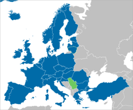
Member states Cooperating states
|
|
| Formation | 1986 |
|---|---|
| Headquarters | Darmstadt, Germany |
|
Membership
|
30 member states |
|
Official language
|
English, German and French |
The European Organisation for the Exploitation of Meteorological Satellites (EUMETSAT) is a special group of countries working together. It was created by an international agreement. Today, 30 European countries are part of EUMETSAT.
EUMETSAT's main goal is to set up, run, and use European systems of weather satellites. These satellites help us understand the weather and climate. EUMETSAT launches and operates these satellites. They also send satellite data to people who need it. This helps monitor the climate and spot global climate changes.
EUMETSAT's work helps a worldwide system of weather satellites. This system is coordinated with other countries that use space technology.
Satellite observations are very important for predicting weather using computers. They also help human weather forecasters see dangerous weather forming. Weather satellites are also becoming more important for collecting long-term data from space. This data helps scientists study how the climate is changing.
EUMETSAT is not part of the European Union. However, most of its members are EU countries. In 2012, EUMETSAT joined the International Charter on Space and Major Disasters. This means its satellites can be used to help people around the world during big emergencies.
Contents
How EUMETSAT Works
EUMETSAT was officially started on June 19, 1986. Member countries contribute money based on their national income. Countries that cooperate but are not full members pay a smaller fee.
Satellite Missions
EUMETSAT uses two main types of satellites:
- Geostationary satellites: These satellites stay in one spot high above the Earth. They give a continuous view of a large part of the Earth.
- Polar-orbiting satellites: These satellites fly much closer to Earth. They provide more detailed information about temperature and moisture in the air. They cover the whole globe, but less often.
Geostationary Satellites: Meteosat
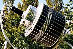
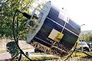
The Meteosat series of satellites are geostationary. They are operated by EUMETSAT. These satellites take pictures of the entire Earth's disc. They also collect data for weather forecasting.
The first Meteosat satellite was launched in 1977. It provided steady observations to many users. People wanted more frequent and detailed data. So, the Meteosat Second Generation (MSG) was developed. MSG satellites are better at quickly spotting and predicting thunderstorms, fog, and small storms. MSG was launched in 2004. A Meteosat Third Generation (MTG) is being prepared. It will meet user needs up to 2025.
Polar-Orbiting Satellites: Metop and Jason/Sentinel-6
Polar-orbiting satellites are very important. They collect data from parts of the world that are hard to observe. This includes the Pacific Ocean and the southern parts of the world. This data helps a lot with computer weather prediction and climate monitoring.
EUMETSAT Polar System (EPS)
The EUMETSAT Polar System (EPS) Metop mission uses three polar-orbiting Metop satellites. They are designed to work one after another for over 14 years. The first, Metop-A, was launched on October 19, 2006. Metop-B was launched on September 17, 2012. The third, Metop-C, was launched on November 7, 2018.
These satellites fly about 817 kilometers (about 508 miles) above Earth. Special tools on board Metop satellites can measure atmospheric temperature and moisture very precisely. They also make sure that remote areas, like Northern Europe and the southern oceans, are fully covered.
The EPS program is also part of a joint effort with NOAA in the United States. This is called the International Joint Polar System (IJPS). NOAA has been running its own series of low Earth orbiting weather satellites since 1960. Many tools on Metop satellites are also on NOAA's POES satellites. This provides similar data across the IJPS.
Jason and Sentinel-6 Missions
The Jason and Sentinel-6 missions focus on measuring the height of the ocean surface. This is crucial for understanding weather and climate change.
- Jason-2
The Jason-2 program was a partnership. It included EUMETSAT, CNES (France), NASA (USA), and NOAA (USA). Jason-2 was launched on June 20, 2008.
Jason-2 provided detailed ocean data. This data helped us understand weather forecasting and climate change. It measured changes in large ocean basins, like the Atlantic Ocean. It also looked at surface wind and wave conditions. Jason-2 data helped improve global weather and ocean forecasts. It also helped scientists learn about El Niño and La Niña. These are important ocean events that affect climate.
- Jason-3
Jason-3 was launched on January 17, 2016. It started working on October 14, 2016. Jason-3 flies in a special orbit about 1336 kilometers (about 830 miles) high. This orbit helps it measure sea level very accurately. Jason-3 is also a cooperation between EUMETSAT, NOAA, CNES, and NASA.
- Sentinel-6/Jason-CS
The Jason satellites were followed by the Sentinel-6 mission. This mission is part of the European Union's Copernicus Programme. Its goal is to provide very precise measurements of global sea-level. This mission is a partnership between the European Commission, EUMETSAT, ESA, NOAA, and NASA. The French space agency, CNES, also helps.
The mission uses two satellites: Sentinel-6 Michael Freilich and Sentinel-6B. They aim to continue high-precision ocean measurements from 2020 to 2030. They also collect detailed temperature profiles of the atmosphere. This helps assess temperature changes and improve weather prediction.
The first satellite, Sentinel-6 Michael Freilich, was launched on November 21, 2020. It was named after Michael Freilich, an oceanographer. Sentinel-6 Michael Freilich took over from Jason-3 in April 2022. The launch of Sentinel-6B is planned for late-2025.
See also
- EUMETNET
- European Centre for Medium-Range Weather Forecasts (ECMWF)
- CNES (French space agency)
- National Oceanic and Atmospheric Administration (NOAA) (US equivalent of EUMETSAT)
- NASA (US space agency, similar to ESA)
 | DeHart Hubbard |
 | Wilma Rudolph |
 | Jesse Owens |
 | Jackie Joyner-Kersee |
 | Major Taylor |


