Eagleswood Township, New Jersey facts for kids
Quick facts for kids
Eagleswood Township, New Jersey
|
|
|---|---|
|
Township
|
|

Municipal building
|
|

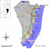
Location of Eagleswood Township in Ocean County highlighted in yellow (right). Inset map: Location of Ocean County in New Jersey highlighted in black (left).
|
|

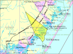
Census Bureau map of Eagleswood Township, New Jersey
|
|
| Country | |
| state | |
| County | |
| Incorporated | March 17, 1874 |
| Government | |
| • Type | Township |
| • Body | Township Committee |
| Area | |
| • Total | 18.96 sq mi (49.11 km2) |
| • Land | 16.10 sq mi (41.71 km2) |
| • Water | 2.86 sq mi (7.41 km2) 15.08% |
| Area rank | 149th of 565 in state 14th of 33 in county |
| Elevation | 13 ft (4 m) |
| Population
(2020)
|
|
| • Total | 1,722 |
| • Estimate
(2023)
|
1,783 |
| • Rank | 499th of 565 in state 24th of 33 in county |
| • Density | 106.9/sq mi (41.3/km2) |
| • Density rank | 537th of 565 in state 33rd of 33 in county |
| Time zone | UTC−05:00 (Eastern (EST)) |
| • Summer (DST) | UTC−04:00 (Eastern (EDT)) |
| ZIP Code |
08092 – West Creek
|
| Area code(s) | 609 Exchanges: 294, 296, 697, 812, 978 |
| FIPS code | 3402918670 |
| GNIS feature ID | 0882068 |
| Website | |
Eagleswood Township is a small community in Ocean County, New Jersey. It's called a township, which is a type of local government area.
In 2020, about 1,722 people lived here. This was the highest number of people recorded in the township's history. The population has been growing steadily over the years.
Eagleswood Township officially became a township on March 17, 1874. It was created from parts of Stafford Township. Later, some parts of Eagleswood were used to form other towns like Beach Haven and Long Beach Township.
Contents
Exploring Eagleswood Township's Location
Eagleswood Township covers about 18.96 square miles (49.11 square kilometers). Most of this area is land, but about 2.86 square miles (7.41 square kilometers) is water. This means it has some beautiful water areas!
You can find several smaller communities and places within Eagleswood Township. These include Coxs, Dinner Point, Mud Cove, and West Creek.
The township shares its borders with other towns in Ocean County. These are Little Egg Harbor Township, Long Beach Township, and Stafford Township.
Who Lives in Eagleswood Township?
The number of people living in Eagleswood Township has changed over time. Here's a quick look at its population history:
| Historical population | |||
|---|---|---|---|
| Census | Pop. | %± | |
| 1880 | 592 | — | |
| 1890 | 791 | 33.6% | |
| 1900 | 563 | * | −28.8% |
| 1910 | 550 | −2.3% | |
| 1920 | 420 | −23.6% | |
| 1930 | 483 | 15.0% | |
| 1940 | 551 | 14.1% | |
| 1950 | 623 | 13.1% | |
| 1960 | 766 | 23.0% | |
| 1970 | 823 | 7.4% | |
| 1980 | 1,009 | 22.6% | |
| 1990 | 1,476 | 46.3% | |
| 2000 | 1,441 | −2.4% | |
| 2010 | 1,603 | 11.2% | |
| 2020 | 1,722 | 7.4% | |
| 2023 (est.) | 1,783 | 11.2% | |
| Population sources: 1880–2000 1880–1920 1880–1890 1890–1910 1910–1930 1940–2000 2000 2010 2020 * = Lost territory in previous decade. |
|||
A Look at the 2010 Census
In 2010, there were 1,603 people living in Eagleswood Township. They lived in 621 households, and 454 of these were families. Most people (96.44%) were White. A small number were Black or African American (0.87%), Asian (0.62%), or from other backgrounds. About 3.37% of the population was Hispanic or Latino.
Many households (30%) had children under 18. Most families (58.6%) were married couples. The average household had about 2.58 people. The average family had 3.00 people.
About 21.7% of the people were under 18 years old. About 13.5% were 65 or older. The average age in the township was 43.1 years.
Learning in Eagleswood Township
Eagleswood Township has its own school district. It serves younger students from pre-kindergarten up to sixth grade. These students attend the Eagleswood Township Elementary School.
In the 2022–23 school year, this school had 143 students. There were 16.6 teachers, meaning about 8.6 students for every teacher. This is a small class size, which can be great for learning!
Older students, from seventh to twelfth grade, attend schools in the Pinelands Regional School District. This district also includes students from nearby towns like Bass River Township, Little Egg Harbor Township, and Tuckerton Borough.
The schools for older students are:
- Pinelands Regional Junior High School: For grades 7-8, with 520 students.
- Pinelands Regional High School: For grades 9-12, with 1,069 students.
Getting Around Eagleswood Township
Eagleswood Township has many roads that help people travel.

Roads and Highways
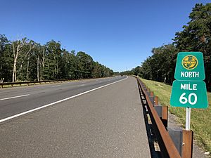
The Garden State Parkway is a major highway that goes through Eagleswood Township. However, there are no exits directly in the township. You would use exits in nearby towns to get on or off the Parkway.
U.S. Route 9 is the main highway that serves Eagleswood directly. It helps people travel to and from the township.
Public Transportation
If you need to travel without a car, there are bus services available.
- NJ Transit offers local bus service on the 559 route. This route connects Eagleswood Township to Atlantic City.
- Ocean Ride also has a local bus service, route OC6, for travel within the area.
Famous Faces from Eagleswood Township
Some interesting people have connections to Eagleswood Township:
- John T. Hendrickson Jr. (1923–1999): He was a politician who served in the New Jersey government from 1982 to 1989.
- George Inness (1825–1894): A very talented landscape painter, known for his beautiful nature scenes.
- Paul Marshall Johnson Jr. (1955–2004): He was an engineer who worked with helicopters.
See also
 In Spanish: Municipio de Eagleswood para niños
 | Delilah Pierce |
 | Gordon Parks |
 | Augusta Savage |
 | Charles Ethan Porter |


