Earling, Iowa facts for kids
Quick facts for kids
Earling, Iowa
|
|
|---|---|

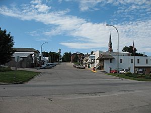
View of Earling main street looking north
|
|

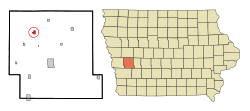
Location of Earling, Iowa
|
|
| Country | |
| State | |
| County | Shelby |
| Area | |
| • Total | 0.63 sq mi (1.63 km2) |
| • Land | 0.63 sq mi (1.63 km2) |
| • Water | 0.00 sq mi (0.00 km2) |
| Elevation | 1,355 ft (413 m) |
| Population
(2020)
|
|
| • Total | 397 |
| • Density | 629.16/sq mi (242.97/km2) |
| Time zone | UTC-6 (Central (CST)) |
| • Summer (DST) | UTC-5 (CDT) |
| ZIP code |
51530
|
| Area code(s) | 712 |
| FIPS code | 19-23385 |
| GNIS feature ID | 2394591 |
Earling is a small city in Shelby County, Iowa, United States. It is located in the midwestern part of the state. In 2020, about 397 people lived there.
Contents
History of Earling, Iowa
Earling began around 1881 and 1882. This was when the Chicago, Milwaukee and St. Paul Railway built its tracks through the area.
The town was officially planned in 1882 by the Milwaukee Land Company. It was first called Marthan. However, there was already a town named Marathon in Iowa. So, the name was quickly changed to Earling. This new name honored Albert J. Earling. He was a superintendent for the Chicago, Milwaukee and St. Paul Railway at that time. He later became the president of the railroad in 1899.
Earling is also known for a historical event that happened in 1928. A Roman Catholic Capuchin priest worked at the local Franciscan convent. He was involved in a series of events that lasted 23 days. A priest later wrote about these events, making various claims about what happened.
Geography and Location
Earling covers a total area of about 0.60 square miles (1.6 square kilometers). All of this area is land. The city is located right on the border between two townships: southeast Union Township and northeast Westphalia Township.
Mosquito Creek is a stream that starts its journey near Earling.
Population and People
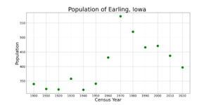
| Historical populations | ||
|---|---|---|
| Year | Pop. | ±% |
| 1900 | 340 | — |
| 1910 | 323 | −5.0% |
| 1920 | 321 | −0.6% |
| 1930 | 358 | +11.5% |
| 1940 | 320 | −10.6% |
| 1950 | 341 | +6.6% |
| 1960 | 431 | +26.4% |
| 1970 | 573 | +32.9% |
| 1980 | 520 | −9.2% |
| 1990 | 466 | −10.4% |
| 2000 | 471 | +1.1% |
| 2010 | 437 | −7.2% |
| 2020 | 397 | −9.2% |
| Source: and Iowa Data Center Source: |
||
Earling's Population in 2020
According to the 2020 census, Earling had 397 residents. There were 176 households in the city. The population density was about 629 people per square mile. Most residents were White. A small percentage identified as Native American or from two or more races. About 1.8% of the population was Hispanic or Latino.
The average age in Earling was 41.6 years. About 25.4% of the people were under 20 years old. Also, 20.7% of the residents were 65 years or older. The number of males and females in the city was almost equal.
Education in Earling
The Harlan Community School District is in charge of the public schools in Earling. This school district serves several towns in the area. These towns include Harlan, Defiance, Earling, Panama, Portsmouth, and Westphalia. It also serves nearby rural areas.
See also
 In Spanish: Earling (Iowa) para niños
 | Madam C. J. Walker |
 | Janet Emerson Bashen |
 | Annie Turnbo Malone |
 | Maggie L. Walker |


