
Early Cape houses of Wells, Maine facts for kids
The Early Cape houses of Wells, Maine are a special group of old homes built in the 1700s. These houses are found in or near the town of Wells, Maine. It's quite unusual to find so many of these old Cape style houses in one place in Maine. In the 1970s, people in Wells looked closely at all the old buildings. They found 19 important Cape houses from the 18th century. These buildings were later added to the National Register of Historic Places in December 1979.
Contents
Discovering Wells' Old Houses
Wells is a town located in York County on the southern coast of Maine. It covers about 50 square miles (130 square kilometers). Most of its coastline is made of sandy beaches, which means it doesn't have a big harbor. This lack of a good harbor affected how the town grew.
Wells was first settled in the 1640s. From the very beginning, it was mostly a farming town. Nearby towns like York and Kennebunkport grew because of fishing, cutting down trees for wood, and trading by sea.
The southern Maine area didn't have many people back then. It was badly damaged by many fights between the British colonies and the French, along with their Native American allies. Because of these attacks in the late 1600s and early 1700s, most people left the area. This is why there are very few buildings in the region that are older than 1710.
Why are These Houses Special?
When people started settling in Wells again in the 1700s, the town grew slowly. This was still because it didn't have a good harbor. It remained a farming area with not many people living close together. This quiet, rural setting helped many of these older, simple farmhouses survive.
The houses listed here are mostly made of wood. They are 1 and a half stories tall. The front of the house usually has five windows or doors across. The roof slopes down on the sides, like a typical Cape house. There is often a large chimney in the middle of the house. The main front door is usually right in the center.
The decorations on these houses are usually simple. The tops of the doors and windows are often placed just below the roof's edge. This is a special feature not usually seen in newer Cape style homes. Over the years, people often added more rooms to the sides or back of these houses. These additions can be from the 1700s all the way up to the 1900s.
Exploring the Old Houses
Nineteen important Cape houses are described below. Each one was added to the National Register of Historic Places on December 27, 1979. While most are in Wells, some are officially listed as being in nearby towns or neighborhoods, like Ogunquit. All but four of these houses are actually inside Wells' town limits. The others are in Ogunquit.
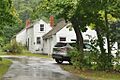
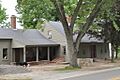
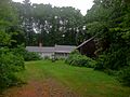
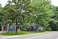
- Austin-Hennessey House: Built before 1725, this house has an attached section and a barn at the back. It's also known as the Storer-Hennessey House.
- Dorfield Farm: This house was built before 1762. It was owned by James Wakefield back then. It has an attached section and a connected barn.
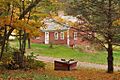
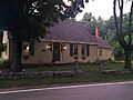
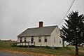
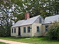
- Early Post Office: We don't know the exact year this house was built, but it was before 1806. One room on the right side of the front had many mail slots. This suggests it was used as an early post office.
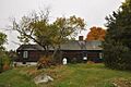
- Eaton House: This house was probably built in the late 1700s. Its chimney has three fireplaces but no baking oven. It was likely built by someone from one of Wells' first families.
- Emery House: Samuel Emery built this house around 1800. It was also called "Rose Cottage" because of the many climbing rose bushes around it.
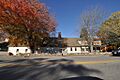
- Goodale-Bourne Farm: This house was built around 1740. Records show Zacharias Goodale, Jr. owned it in 1749. It is actually located in Ogunquit.
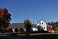
- Goodale-Stevens Farm: Zachariah Goodale built this house around 1725. The land might have been cleared as early as 1699. It's a short distance east of, and across the street from, the Goodale-Bourne Farm. It is also in Ogunquit.
- Hatch House: Jeremiah Hatch probably built this house around 1800.
- Littlefield Homestead: This house was likely built before 1780. Joseph Littlefield sold it to Joshua Littlefield that year.
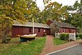
- Littlefield Tavern: Captain James Littlefield built this house around 1690. For many years, it served as a tavern.
- Littlefield-Chase Farmstead: This house was built in 1776 by either Daniel or Dependence Littlefield.
- Littlefield-Dustin Farm: Records show this house existed in 1784. However, its style suggests it's much older. It was owned by one of the Littlefields, who were early settlers of Wells.
- Littlefield-Keeping House: This house was probably built between 1776 and 1799. It originally had three sections across the front, with the door in the middle. The two outer sections and another addition were added later.
- Lord Farm: Based on its style, this house was built in the mid-to-late 1700s. Its first recorded owner in 1781 was a member of the Wells family.
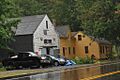
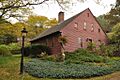
- Mill House: This house was built around 1750. Its owners ran a mill on Stevens Brook, which flows south of the property. Today, the house is an antiques shop.
- Charles Perkins House: This house was probably built in the mid-to-late 1700s. At that time, David Maxwell owned the property. This house is actually in Ogunquit.
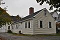
- Wells Baptist Church Parsonage: Records show a member of the Littlefield family owned this house in 1779. In 1845, Clement Littlefield sold it to the local Baptist church to be used as a home for their minister (parsonage).
- Wells Homestead: This is one of the oldest houses in Wells. Its history goes back to 1707. An inside beam even has the date 1696 carved into it! People believe this house might have been built in 1696, burned by Native Americans in 1702, and then rebuilt in 1710.
- Winn House: This house was originally on U.S. Route 1. In the 1980s, it was moved to a park on Obed's Lane and is now a museum. It's thought to have been built in the 1780s. This house is also in Ogunquit.
Images for kids
-
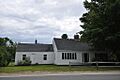
Austin-Hennessey House
-
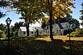
Dorfield Farm
-
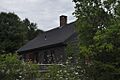
Early Post Office
-
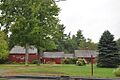
Eaton House
-
Emery House
-
Goodale-Bourne Farm
-
Goodale-Stevens Farm
-
Hatch House
-
Littlefield Homestead
-
Littlefield Tavern
-
Littlefield-Chase Farmstead
-
Littlefield-Dustin Farm
-
Littlefield-Keeping House
-
Lord Farm
-
Mill House
-
Charles Perkins House
-
Wells Baptist Church Parsonage
-
Wells Homestead
-
Winn House


.jpg)

