East Missoula, Montana facts for kids
Quick facts for kids
East Missoula, Montana
|
|
|---|---|

East Missoula, Montana
|
|

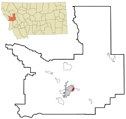
Location in Missoula County and the state of Montana
|
|
| Country | United States |
| State | Montana |
| County | Missoula |
| Area | |
| • Total | 1.25 sq mi (3.23 km2) |
| • Land | 1.21 sq mi (3.12 km2) |
| • Water | 0.04 sq mi (0.11 km2) |
| Elevation | 3,264 ft (995 m) |
| Population
(2020)
|
|
| • Total | 2,465 |
| Time zone | UTC-7 (Mountain (MST)) |
| • Summer (DST) | UTC-6 (MDT) |
| ZIP code |
59802 (Missoula)
|
| Area code(s) | 406 |
| FIPS code | 30-23200 |
| GNIS feature ID | 0782938 |
East Missoula is a small community in Missoula County, Montana, in the United States. It is called a "census-designated place" (CDP) because it's a special area the government counts for population. East Missoula is part of the larger Missoula metropolitan area. In 2020, about 2,465 people lived here. This was a bit more than the 2,157 people counted in 2010.
Contents
Where is East Missoula Located?
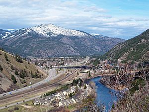
East Missoula is found in the middle of Missoula County. It sits right next to the city of Missoula on its western side. The Clark Fork River flows along the eastern edge of the community. On the other side of the river is another part of Missoula.
Important roads run through East Missoula. Former U.S. Route 10 and Montana Highway 200 go right through the center. Also, Interstate 90 is on the southern side, and you can get to East Missoula from Exit 107.
How Big is East Missoula?
The area of East Missoula is about 1.25 square miles (3.23 square kilometers). Most of this area is land, about 1.21 square miles (3.12 square kilometers). A small part, about 0.04 square miles (0.11 square kilometers), is water.
What is the Weather Like?
East Missoula has a climate with big changes in temperature throughout the year. Summers are usually warm to hot, and sometimes humid. Winters are cold, and can be very cold. This type of weather is known as a humid continental climate.
Who Lives in East Missoula?
The number of people living in East Missoula has grown over the years.
| Historical population | |||
|---|---|---|---|
| Census | Pop. | %± | |
| 1980 | 1,707 | — | |
| 2000 | 2,070 | — | |
| 2010 | 2,156 | 4.2% | |
| 2020 | 2,465 | 14.3% | |
| U.S. Decennial Census | |||
In 2010, there were 2,157 people living in East Missoula. There were 795 households, which are groups of people living together in one home. About 519 of these were families.
Most people in East Missoula are White (about 93.57%). There are also people who are Native American (about 3.24%), African American (0.34%), and Asian (0.48%). Some people are from other backgrounds or a mix of two or more races. About 1.64% of the population were Hispanic or Latino.
Families and Ages
About 33% of the households in East Missoula had children under 18 years old. Many households (48.6%) were married couples living together. Some households (11.6%) had a female head of the house without a husband. About 34.6% of households were not families.
The average household had about 2.50 people. The average family had about 3.01 people.
Looking at ages, about 24.3% of the people were under 18. About 10.3% were between 18 and 24 years old. The largest group, 31.8%, was between 25 and 44 years old. About 10.7% of the people were 65 years or older. The average age in East Missoula was 36 years.
Education in East Missoula
Students in East Missoula attend different schools depending on where they live. Part of the community is in the Bonner Elementary School District. The other part is in the Missoula Elementary School District. However, all high school students in East Missoula attend schools in the Missoula High School District.
See also
 In Spanish: East Missoula (Montana) para niños
 | Percy Lavon Julian |
 | Katherine Johnson |
 | George Washington Carver |
 | Annie Easley |

