East Palatka, Florida facts for kids
Quick facts for kids
East Palatka, Florida
|
|
|---|---|

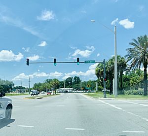
Intersection of U.S. Route 17/State Road 20/State Road 100 and the southwestern terminus of State Road 207
|
|

Location in Putnam County and the state of Florida
|
|
| Country | |
| State | |
| County | Putnam |
| Area | |
| • Total | 4.71 sq mi (12.20 km2) |
| • Land | 3.18 sq mi (8.24 km2) |
| • Water | 1.53 sq mi (3.97 km2) |
| Elevation | 16 ft (5 m) |
| Population
(2020)
|
|
| • Total | 1,573 |
| • Density | 494.65/sq mi (191.01/km2) |
| Time zone | UTC-5 (Eastern (EST)) |
| • Summer (DST) | UTC-4 (EDT) |
| ZIP code |
32131
|
| Area code(s) | 386 |
| FIPS code | 12-19350 |
| GNIS feature ID | 0282007 |
East Palatka is a small community in Putnam County, Florida, USA. It is known as a census-designated place (CDP). This means it's a place with a name and a population, but it's not officially a city or town.
East Palatka is located just east of the city of Palatka. Important roads like U.S. Route 17 and State Road 20 meet here. In 2020, about 1,573 people lived there. East Palatka is also home to the Palatka State Farmer's Market and the Putnam County Fairgrounds.
Contents
Geography of East Palatka
East Palatka is located at 29°39′00″N 81°35′58″W / 29.650024°N 81.599397°W.
This community covers about 4.5 square miles (11.6 square kilometers). Most of this area is land. However, about 1.3 square miles (3.4 square kilometers) is water. The famous St. Johns River flows through or near East Palatka.
People of East Palatka
| Historical population | |||
|---|---|---|---|
| Census | Pop. | %± | |
| 1990 | 1,989 | — | |
| 2000 | 1,707 | −14.2% | |
| 2010 | 1,654 | −3.1% | |
| 2020 | 1,573 | −4.9% | |
| U.S. Decennial Census | |||
In the year 2000, there were 1,707 people living in East Palatka. These people lived in 521 households. A household is a group of people living in one home. About 365 of these households were families.
The population density was about 532 people per square mile (205 people per square kilometer). This tells us how many people live in a certain area. There were also 594 housing units, which are places where people can live.
Most of the people in East Palatka were White (about 59.6%). About 37.3% were African American. Smaller groups included Native American, Asian, and people of two or more races. About 2.4% of the population was Hispanic or Latino.
Households and Families
About 28.6% of households had children under 18 living with them. Many households (50.5%) were married couples living together. About 15.5% of households had a female head with no husband present.
The average household had 2.50 people. The average family had 2.98 people.
Age and Income
The population was spread out by age. About 18.5% were under 18 years old. About 36.7% were between 25 and 44 years old. The median age was 38 years. This means half the people were younger than 38, and half were older.
The median income for a household was $37,857 per year. For families, the median income was $46,071. The average income per person was $18,478. About 17.4% of all people lived below the poverty line. This included 41.4% of those under 18.
See also
 In Spanish: East Palatka para niños
 | Isaac Myers |
 | D. Hamilton Jackson |
 | A. Philip Randolph |

