East Pasadena, California facts for kids
Quick facts for kids
East Pasadena, California
|
|
|---|---|

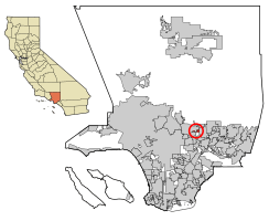
Location of East Pasadena in Los Angeles County, California.
|
|
| Country | |
| State | |
| County | |
| Area | |
| • Total | 1.32 sq mi (3.43 km2) |
| • Land | 1.32 sq mi (3.41 km2) |
| • Water | 0.01 sq mi (0.01 km2) 0.39% |
| Elevation | 725 ft (221 m) |
| Population
(2020)
|
|
| • Total | 6,021 |
| • Density | 4,571.75/sq mi (1,764.74/km2) |
| Time zone | UTC-8 (PST) |
| • Summer (DST) | UTC-7 (PDT) |
| ZIP code |
91107
|
| Area code(s) | 626 |
| FIPS code | 06-20984 |
| GNIS feature ID | 1660585 |
East Pasadena () is a place in Los Angeles County, California, United States. It's an unincorporated community, which means it's not officially a city with its own local government. Instead, it's managed by the county.
In 2020, about 6,021 people lived in East Pasadena. This number was a little lower than in 2010, when 6,144 people lived there. For counting purposes, the United States Census Bureau calls East Pasadena a census-designated place (CDP). This just means it's a specific area they count for statistics.
Contents
Where is East Pasadena?
East Pasadena is located in California, a state in the United States. It's part of Los Angeles County.
East Pasadena's Unique Shape
The land area of East Pasadena is split into two parts that don't touch each other.
- The main part is next to Pasadena city limits on the north. It's bordered by California Boulevard to the south. To the east, you'll find Michillinda Avenue (which is near Arcadia). To the west is San Gabriel Boulevard.
- A smaller part is to the west. It's bordered by Del Mar Boulevard on the north and San Marino city limits on the south. Berkeley Avenue is to the west, and San Gabriel Boulevard is to the east.
Over time, East Pasadena has gotten smaller. This is because the city of Pasadena has grown and taken over some of the areas that used to be part of East Pasadena.
How Big is East Pasadena?
According to the United States Census Bureau, East Pasadena covers about 1.3 square miles (3.4 km2) of land. This area is defined for counting people and might not exactly match what local people think of as East Pasadena.
Chapman Woods Neighborhood
A large part of the Chapman Woods neighborhood is in East Pasadena. However, some parts of Chapman Woods are also inside the city of Pasadena.
Chapman Woods is bordered by Del Mar Boulevard to the north and Huntington Drive to the south. The Eaton Wash is to the west, and Highway 19 (Rosemead Boulevard) is to the east. This neighborhood is named after Alfred Chapman. He bought the land and built his home there a long time ago. You can still see signs that say "Chapman Woods" at the entrances to the neighborhood.
Shopping and Schools
You'll find many shops and businesses along Foothill Boulevard, Colorado Boulevard, and Highway 19. Two important schools in the area are Willard Elementary School and Wilson Middle School. They are located across the street from each other on Madre Street.
Who Lives in East Pasadena?
Let's look at some facts about the people who live in East Pasadena.
Population Changes Over Time
The number of people living in East Pasadena has changed over the years:
- In 1990, there were 5,910 people.
- In 2000, the population grew slightly to 6,045.
- In 2010, it reached 6,144.
- By 2020, the population was 6,021.
East Pasadena in 2010
In 2010, there were 6,144 people living in East Pasadena. Most people (99.6%) lived in homes, while a very small number lived in group homes or institutions.
There were 2,096 households. About one-third of these households had children under 18. The average household had about 2.92 people.
The ages of people living in East Pasadena in 2010 were:
- 21.2% were under 18 years old.
- 8.3% were between 18 and 24 years old.
- 26.8% were between 25 and 44 years old.
- 28.1% were between 45 and 64 years old.
- 15.6% were 65 years or older.
The average age of people in East Pasadena was 40.5 years.
Animals in East Pasadena
You might see wild peafowl (peacocks and peahens) roaming around East Pasadena. They are also common in nearby places like Arcadia and San Marino.
In 2021, local leaders decided to ban feeding peafowl. This was because their numbers had grown a lot. The cities of Pasadena and Arcadia already had rules against feeding these birds.
Schools in East Pasadena
Students in East Pasadena attend schools from two different school districts:
- The San Marino Unified School District serves the southwest part of the community.
- The Pasadena Unified School District serves the area along Rosemead Boulevard.
Getting Around East Pasadena
East Pasadena has several ways to get around using public transportation.
The Metro A Line train has a station at Sierra Madre Villa Avenue and Foothill Boulevard.
You can also use buses to travel around the neighborhood. These include:
- Metro Local lines 266 and 267.
- Pasadena Transit routes 31, 32, 40, and 60.
- Foothill Transit Route 187.
See also
 In Spanish: East Pasadena para niños
 | Victor J. Glover |
 | Yvonne Cagle |
 | Jeanette Epps |
 | Bernard A. Harris Jr. |


